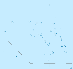
Midway Atoll is a 2.4 sq mi (6.2 km2) atoll in the North Pacific Ocean. Midway Atoll is an insular area of the United States and is an unorganized and unincorporated territory. The largest island is Sand Island, which has housing and an airstrip. Immediately to the east of Sand Island across the narrow Brooks Channel is Eastern Island, which is uninhabited and no longer has any facilities. Forming a rough, incomplete circle around the two main islands and creating Midway Lagoon is Spit Island, a narrow reef.

The United States Minor Outlying Islands is a statistical designation defined by the International Organization for Standardization's ISO 3166-1 code. The entry code is ISO 3166-2:UM. The minor outlying islands and groups of islands comprise eight United States insular areas in the Pacific Ocean and one in the Caribbean Sea.

Wake Island, also known as Wake Atoll, is a coral atoll in the Micronesia subregion of the Pacific Ocean. The atoll is composed of three islets and a reef surrounding a lagoon. The nearest inhabited island is Utirik Atoll in the Marshall Islands, located 592 miles to the southeast.
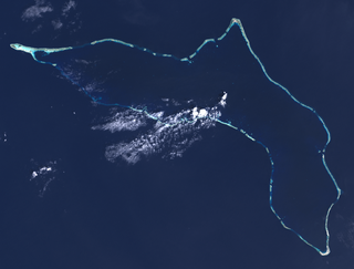
Kwajalein Atoll is part of the Republic of the Marshall Islands (RMI). The southernmost and largest island in the atoll is named Kwajalein Island, which its majority English-speaking residents often use the shortened name, Kwaj. The total land area of the atoll amounts to just over 6 square miles (16 km2). It lies in the Ralik Chain, 2,100 nautical miles southwest of Honolulu, Hawaii.

Enewetak Atoll is a large coral atoll of 40 islands in the Pacific Ocean and with its 296 people forms a legislative district of the Ralik Chain of the Marshall Islands. With a land area total less than 5.85 square kilometers (2.26 sq mi), it is no higher than 5 meters (16.4 ft) and surrounds a deep central lagoon, 80 kilometers (50 mi) in circumference. It is the second-westernmost atoll of the Ralik Chain and is 305 kilometers (190 mi) west from Bikini Atoll.

Attu is an island in the Near Islands. It is one of the westernmost points of the U.S. state of Alaska. The island became uninhabited in 2010, making it the largest uninhabited island that is part of the United States politically.

This is a list of hospitals in Oceania for each sovereign state, associated states of New Zealand, and dependencies, and territories. Links to lists of hospitals in countries are used when there are more than a few hospitals in the country. Oceania has an area of 8,525,989 km2 and population of 41,570,842 (2018). The World Health Organization surveys of healthcare in smaller countries are used to identify hospitals in smaller countries.

The Battle of Kwajalein was fought as part of the Pacific campaign of World War II. It took place 31 January – 3 February 1944, on Kwajalein Atoll in the Marshall Islands. Employing the hard-learned lessons of the Battle of Tarawa, the United States launched a successful twin assault on the main islands of Kwajalein in the south and Roi-Namur in the north. The Japanese defenders put up stiff resistance, although outnumbered and under-prepared. The determined defense of Roi-Namur left only 51 survivors of an original garrison of 3,500.
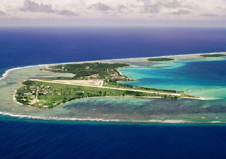
Roi-Namur is an island in the north part of the Kwajalein Atoll in the Marshall Islands. Today it is a major part of the Ronald Reagan Ballistic Missile Defense Test Site, hosting several radar systems used for tracking and characterizing missile reentry vehicles (RV) and their penetration aids (penaids). A flooding event by wave overtopping made national news in the United States, with dramatic footage of water bursting through a door.

Likiep Atoll is a coral atoll of 65 islands in the Pacific Ocean, and forms a legislative district of the Ratak Chain of the Marshall Islands. It is approximately 55 kilometers (34 mi) northwest of Wotje. Its total land area is only 10.26 square kilometers (3.96 sq mi), but that encloses a deep central lagoon of 424 square kilometers (164 sq mi). Likiep Atoll also possesses the Marshall Islands' highest point, an unnamed knoll 10 meters (33 ft) above sea level. The population of Likiep Atoll was 228 in 2021.
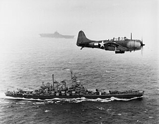
The Gilbert and Marshall Islands campaign were a series of battles fought from August 1942 through February 1944, in the Pacific theatre of World War II between the United States and Japan. They were the first steps of the drive across the Central Pacific by the United States Pacific Fleet and Marine Corps. The purpose was to establish airfields and naval bases that would allow air and naval support for upcoming operations across the Central Pacific. Operation Galvanic and Operation Kourbash were the code names for the Gilberts campaign that included the seizures of Tarawa and Makin, during the Battle of Tarawa on 20–23 November 1943 and the Battle of Makin on 20–24 November 1943. Operation Flintlock and Operation Catchpole were aimed at capturing Japanese bases at Kwajalein, Eniwetok, and Majuro in the Marshall Islands.
Taroa Airfield was a major air base approximately three miles long and one mile wide on Taroa Island in the Maloelap Atoll in the Marshall Islands. The runway, which spanned the length of the island, is still in use today and known as Maloelap Airport.

Landing Beaches; Aslito/Isely Field & Marpi Point, Saipan Island is a National Historic Landmark District consists of several discontiguous areas of the island of Saipan in the Northern Mariana Islands. The sites were designated for their association with the Japanese defense of Saipan during World War II, the 1944 Battle of Saipan in which United States forces captured the island, and the subsequent campaigns which used Saipan as a base. The district includes the landing beaches where the U.S. forces landed, the remnants of Japanese airfields Aslito and Marpi Point and Isely Field, the airfield built over much of Aslito from which B-29 bombers were used to bomb the Japanese home islands. The Marpi Point area includes Suicide Cliff and Banzai Cliff, two locations where significant numbers of Japanese military and civilians jumped to their deaths rather than surrender to advancing U.S. forces. The loss of Saipan was a major blow to the Japanese war effort, leading to the resignation of Prime Minister Hideki Tojo, The landmark designation was made in 1985.

Orote Field is a former air base in the United States territory of Guam built by the Empire of Japan with Chamorro forced labor during the Japanese occupation of Guam (1941-1944). It is separate from the Marine Corps amphibious airplane base at located at Sumay village that was operational from 1921 to 1931. Following the liberation of Guam in 1944, the U.S. military repaired the field for further use in the Pacific War.
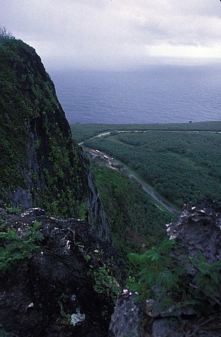
Suicide Cliff is a cliff above Marpi Point Field near the northern tip of Saipan, Northern Mariana Islands, which achieved historic significance late in World War II.
The Japanese Lighthouse, or Poluwat Lighthouse, is an abandoned lighthouse situated on Alet Island in Poluwat, Chuuk in the Federated States of Micronesia. It was completed in 1940 by the Japanese and was in use until being attacked by U.S. forces in World War II. It was listed on the National Register of Historic Places in 1983. The lighthouse is a good example of pre-World War II "marine architecture" built by the Japanese.
The Joachim DeBrum House, known simply as the DeBrum House and also spelled Debrum House or De Brum House, located on Likiep Island, of Likiep Atoll, in the Marshall Islands, is a plantation house that was built in 1888 by Joachim DeBrum. It was listed on the United States National Register of Historic Places in 1976, making it the first NRHP site in Micronesia.

Naval Base Majuro was a major United States Navy base built on Majuro Atoll, in the Marshall Islands to support the World War II efforts in the Pacific War. The base was built after the Battle of Majuro-Kwajalein ended 3 February 1944. Majuro was found to be unoccupied and abandoned when the United States Army arrived. The US Navy built airfields, a seaport, and other facilities on the captured islands. The base was part of the vast Naval Base Marshall Islands.

Naval Base Marshall Islands were United States Navy advance bases built on the Marshall Islands during World War II to support the Pacific War efforts. The bases were built by US Navy after the Marshall Islands campaign that captured the islands from the Empire of Japan. By February 1944 the United States Armed Forces had captured the islands. Most of the airfields and other facilities Japan had built were destroyed in allied bombing raids and naval bombardment. US Navy Seabee Construction Battalions arrived as soon as the area was secured and remove the debris. The Seabees quickly repaired, built and improved the airfield/runways and seaport. Seabees often worked around the clock to get airfields operational so that fighter aircraft and bombers could start operating. The bases were used for staging upcoming campaigns and for repair.
