Related Research Articles

Mejit is an island in the Pacific Ocean, and forms a legislative district of the Ratak Chain of the Marshall Islands. Unlike most of the other islands of the Marshall Islands, Mejit is a stony island rather than a coral atoll, although it is surrounded by a fringing coral reef enclosing a narrow lagoon. It is located east of the main line of the Ratak chain, approximately 110 kilometers (68 mi) northeast from Wotje. The population was 230 at the 2021 census.
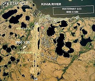
Chefornak Airport is a state-owned public-use airport in Chefornak, a city in the Bethel Census Area of the U.S. state of Alaska. The airport is on the Kinia River.
Jaluit Airport is a public use airstrip located one nautical mile (1.85 km) southwest of the village of Jabor on Jaluit Atoll, Marshall Islands. This airstrip is assigned the location identifier N55 by the FAA and UIT by the IATA.
Kili Airport is a public use airstrip on Kili Island, Marshall Islands. This airstrip is assigned the location identifier Q51 by the FAA and KIO by the IATA.
Mili Airport is a public use airstrip in the village of Mili on Mili Atoll, Marshall Islands. This airstrip is assigned the location identifier 1Q9 by the FAA and MIJ by the IATA.
Namorik Airport is a public use airstrip located at Namorik on Namorik Atoll, Marshall Islands. This airstrip is assigned the location identifier 3N0 by the FAA and NDK by the IATA.
Utirik Airport is a public use airstrip on Utirik Island in Utirik Atoll, Marshall Islands. This airstrip is assigned the location identifier 03N by the FAA and UTK by the IATA.
Wotje Airport is a public use airstrip located in the village of Wotje on Wotje Atoll, Marshall Islands. This airstrip is assigned the location identifier N36 by the FAA and WTE by the IATA.
MJB may refer to:
Ouzinkie Airport is a state-owned public-use airport serving Ouzinkie, a city on Spruce Island in the Kodiak Island Borough of the U.S. state of Alaska.

Angaur Airstrip is a small airstrip on Angaur, one of the islands of Palau. It also served as an airfield during World War II.

French Frigate Shoals Airport is a private use airport on Tern Island in French Frigate Shoals, a coral atoll, in Hawaii, United States. It is owned by the United States Fish and Wildlife Service, as part of the Hawaiian Islands National Wildlife Refuge.
Ine Airport is a public use airstrip located in the village of Ine on Arno Atoll, Marshall Islands. This airstrip is assigned the location identifier N20 by the FAA and IMI by the IATA.
Tinak Airport,, is a public use airstrip located in the village of Tinak on Arno Atoll, Marshall Islands.
Point Lonely Short Range Radar Site is a United States Air Force Short Range Radar Site located in the North Slope Borough of the U.S. state of Alaska, 84 miles (135 km) east-southeast of Point Barrow, Alaska. It is not open for public access.
Cape Romanzof LRRS Airport is a military airstrip located six nautical miles southeast of Cape Romanzof, in the Kusilvak Census Area of the U.S. state of Alaska. It is not open for public use.
Sparrevohn LRRS Airport is a military airstrip located south of Sparrevohn, in the Bethel Census Area of the U.S. state of Alaska. The airstrip is also located 129 miles (208 km) south of McGrath, Alaska, and 188 miles (303 km) west of Anchorage, Alaska. It is not open for public use.
Driftwood Bay Air Force Station is a private use military airstrip located 13 nautical miles northwest of Unalaska Island, in the Aleutians East Borough of the U.S. state of Alaska. It is privately owned by the United States Air Force. The facility is not open for public use.
Santa Cruz Island Airport is a former airstrip on Santa Cruz Island in Santa Barbara County, California, United States. It is located 24 nautical miles southwest of the City of Santa Barbara. This airport was owned by The Nature Conservancy but is no longer registered. It is not to be confused with Christy Airstrip or Santa Cruz Ranch Airport, the currently active airstrips on Santa Cruz Island and also owned by The Nature Conservancy.
References
- 1 2 3 4 FAA Airport Form 5010 for Q30 PDF , effective 2009-10-22.
- ↑ "MJB - Mejit Atoll, Marshall Islands - Mejit Airport". Great Circle Mapper. Retrieved 2011-01-26.