
Railways: 0 km

The flag of the Republic of the Marshall Islands, an island nation in the Pacific, was adopted upon the start of self-government, May 1, 1979. The flag was designed by Emlain Kabua, who served as the first First Lady of the republic.
Krusenstern Island is a toponym honoring the Baltic German explorer Adam Johann von Krusenstern (1770–1846). It may refer to a number of places in the Pacific Ocean:

The Ratak Chain is a chain of islands and atolls within the island nation of the Marshall Islands. Ratak means "sunrise". It lies to the east of the country's other island chain, the Ralik Chain. In 1999, the total population of the Ratak islands was 30,925.
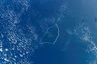
The Maloelap Atoll is a coral atoll of 71 islands in the Pacific Ocean, and forms a legislative district of the Ratak Chain of the Marshall Islands. Its land area is only 9.8 square kilometers (3.8 sq mi), but that encloses a lagoon of 972 square kilometers (375 sq mi). It is located 18 kilometers (11 mi) north of the atoll of Aur. The population of the atoll was 395 at the 2021 census.
Ailinglaplap or Ailinglapalap is a coral atoll of 56 islands in the Pacific Ocean, and forms a legislative district of the Ralik Chain in the Marshall Islands. It is located 152 kilometres (94 mi) northwest of Jaluit Atoll. Its total land area is only 14.7 square kilometers (5.7 sq mi), but it encloses a lagoon of 750 square kilometers (290 sq mi). The economy of the atoll is dominated by coconut plantations. The population of the atoll was 1,175 in 2021. Jabat Island is located off the coast of Ailinglaplap Atoll. The former president of the Marshall Islands, Kessai Note, was born on Jeh Island, Ailinglaplap Atoll.
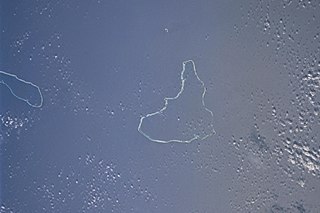
Ailuk Atoll is a coral atoll of 57 islets in the Pacific Ocean, and forms a legislative district of the Ratak Chain of the Marshall Islands. It is located approximately 72 kilometers (45 mi) north from Wotje. Its total land area is only 5.4 square kilometers (2.1 sq mi), but it encloses a lagoon with an area of 177.45 square kilometers (68.51 sq mi). The major islets are: Ajelep, Aliej, Ailuk, Alkilwe, Barorkan, Biken, Enejabrok, Enejelar, Kapen and Marib. Most of the islets are on the eastern side of the atoll. The western and southern sides of the atoll have a nearly continuous submerged coral reef, with three main passes that lead into the lagoon: Erappu Channel, Marok Channel and Eneneman Channel on the west side.
Aur Atoll is a coral atoll of 42 islands in the Pacific Ocean, and forms a legislative district of the Ratak Chain of the Marshall Islands. Its total land area is only 15 square kilometers (5.6 sq mi), but it encloses a lagoon with an area of 620 square kilometers (240 sq mi). It is located south of Maloelap Atoll. The population of Aur Atoll was 317 in 2021.

Likiep Atoll is a coral atoll of 65 islands in the Pacific Ocean, and forms a legislative district of the Ratak Chain of the Marshall Islands. It is approximately 55 kilometers (34 mi) northwest of Wotje. Its total land area is only 10.26 square kilometers (3.96 sq mi), but that encloses a deep central lagoon of 424 square kilometers (164 sq mi). Likiep Atoll also possesses the Marshall Islands' highest point, an unnamed knoll 10 meters (33 ft) above sea level. The population of Likiep Atoll was 228 in 2021.

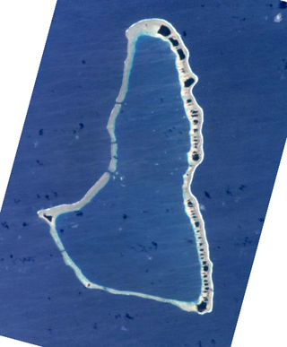
Utirik Atoll or Utrik Atoll is a coral atoll of 10 islands in the Pacific Ocean, and forms a legislative district of the Ratak Chain of the Marshall Islands. Its total land area is only 2.4 square kilometers (0.94 sq mi), but it encloses a lagoon with an area of 57.7 square kilometers (22.29 sq mi). It is located approximately 47 kilometers (29 mi) east of Ujae Atoll. The population of Utirik Atoll was 264 at the 2021 census. It is one of the northernmost Marshall Islands with permanent habitation.

Mejit is an island in the Pacific Ocean, and forms a legislative district of the Ratak Chain of the Marshall Islands. Unlike most of the other islands of the Marshall Islands, Mejit is a stony island rather than a coral atoll, although it is surrounded by a fringing coral reef enclosing a narrow lagoon. It is located east of the main line of the Ratak chain, approximately 110 kilometers (68 mi) northeast from Wotje. The population was 230 at the 2021 census.
Remios Hermios is one of two iroijlaplap of the Ratak Chain in the Marshall Islands. His traditional domain includes the atolls of Aur, Maloelap, Erikub, Wotje, Likiep, Ailuk, Utirik and Taongi; he and his predecessors have also laid claim to U.S.-administered Wake Island. The other paramount chief in the chain is incumbent president, Jurelang Zedkaia, whose domain covers Majuro, Arno and Mili atolls.

Defense of the Marshall Islands is the responsibility of the United States, but local police matters are handled by the Marshall Islands Police, the national police force, as well as several atoll or municipality-based departments. There are two police forces which function under the name Kwajalein Police, a municipal department known otherwise as Kalgov Police, in addition to law enforcement on the U.S. military base on Kwajalein Atoll separate from the Government of the Marshall Islands, which is handled by the Department of the Army Civilian Police from the United States. Previously, the law enforcement activity on the U.S. military installation was the responsibility of government contractor Alutiiq, LLC, which operated as “Kwajalein Police Department”, a government-owned, contractor operated entity. This operation transitioned to federal employees instead of the use of contractor-provided police officers under the administration of President Barack Obama, who directed federal agencies to review whether certain types of work should be reserved for federal employees as inherently governmental functions. While the law enforcement role on Kwajalein has transitioned to Department of the Army civilian police officers, who are federal employees, Alutiiq still remains on Kwajalein, as the “Security and Access Control Contractor”, providing security guard patrols, Customs/TSA services, marine patrol, and explosives/narcotics detection canines.
Krusenstern or Kruzenshtern may refer to:

The following is an alphabetical list of topics related to the Marshall Islands.

Republic of Marshall Islands Public School System (PSS) is the public school system of the Marshall Islands, headquartered in Majuro. It was established in November 2013 by Public Law 2013-23.
Northern Islands High School (NIHS) is a secondary school in Wotje, Marshall Islands. It is a part of the Marshall Islands Public School System.

Marshallese cuisine comprises the fare, foods, beverages and foodways of the Marshall Islands, including its food-related customs and traditions. Common indigenous and traditional foods include breadfruit, coconut, bananas, papaya, seafood, pandanus and bwiro. Additional imported foods, such as rice and flour, are also a part of people's diets and contribute to the cuisine as well. The practice of food preservation is a part of the history of the islands, and continues to occur today.
Events in the year 2020 in the Marshall Islands.
The Council of Iroij, also known as the House of Iroij, is a consultative body in the Marshall Islands provided for by the constitution. Its twelve members consist of the Iroij, the traditional chiefs of the islands. The Council of Iroij has the power to review any proposed legislation affecting land rights or traditional practices.
