Marshall Islands International Airport

Last updated
Amata Kabua International Airport

Marshall Islands International Airport
Welcome to Majaro.jpg
Welcome
Summary
Airport typePublic
OperatorRMI Ports Authority
ServesMajuro
LocationMajuro
Elevation  AMSL 6 ft / 2 m
Coordinates 07°03′53″N171°16′19″E / 7.06472°N 171.27194°E / 7.06472; 171.27194
Map
Marshall Islands location map.svg
Airplane silhouette.svg
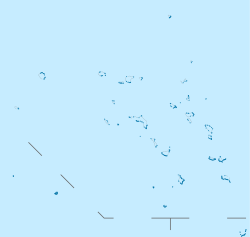
Amata Kabua International Airport
location of the Airport in Majuro, Marshall Islands
Oceania laea location map.svg
Airplane silhouette.svg
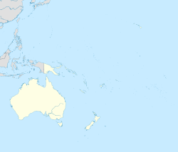
Amata Kabua International Airport
Amata Kabua International Airport (Oceania)
Runways
Direction LengthSurface
ftm
07/257,8972,407 Asphalt

Marshall Islands International Airport( IATA : MAJ, ICAO : PKMJ, FAA LID : MAJ), also known as Amata Kabua International Airport, is located in the western part of Rairok on the south side of Majuro Atoll, the capital of the Republic of the Marshall Islands. The airport was built during World War II (1943) on Anenelibw and Lokojbar islets. [1] It replaced Majuro Airfield, a coral-surfaced airstrip at Delap Island near the eastern end of Majuro Atoll that had been originally constructed by Japanese occupation forces in 1942. [2] [3]

Contents

A series of single-floor structures (small hangars) make up the airport terminal. No physical structures existed at the airport prior to the 1970s. The current terminal structure and modern runway/apron were built in 1971. [4] Passengers from flights arriving at the airport use stairs to exit aircraft and walk to the terminal.

The airport is capable of handling all propeller-driven aircraft as well as midsize jet aircraft (e.g., Airbus A320s, Boeing 737s, Boeing 757s and Boeing 767s).

The Republic of the Marshall Islands Ports Authority replaced the Marshall Islands Airports Authority in managing the airport in 2003 under RMI Port Authority Act. [5] [6]

Airport improvements

Sea walls have been added to prevent the sea from reclaiming the infill used to create the airport.[ when? ]

Between 2007 and 2009, airport improvement projects replaced the runway surfaces, rebuilt the apron to better handle aircraft, and repaved and added markings to the runway. [7] In 2007 the US FAA added two new airport crash tenders to the existing three-tender fleet, as part of the airport improvement projects. [7]

Airlines and destinations

AirlinesDestinations
Air Marshall Islands Ailuk, Airok, Aur, Bikini, Ebon, Elenak, Enejit, Enewetak, Jaluit, Jeh, Kaben, Kili, Kwajalein, Lae, Majkin, Maloelap, Mejit, Mili, Namdrik, Rongelap, Ujae, Utirik, Wotho, Wotje
Nauru Airlines Brisbane, Nauru, [8] Pohnpei, [9] Tarawa [8]
United Airlines Chuuk, Guam, Honolulu, Kosrae, Kwajalein, Pohnpei

Ground transportation

Taxis and shuttle buses provide ground transportation to and from the airport to other areas of the island.[ citation needed ] The main and only road on Majuro Island provides access to the airport.

See also

Related Research Articles

<span class="mw-page-title-main">Majuro</span> Capital of the Marshall Islands

Majuro is the capital and largest city of the Marshall Islands. It is also a large coral atoll of 64 islands in the Pacific Ocean. It forms a legislative district of the Ratak (Sunrise) Chain of the Marshall Islands. The atoll has a land area of 9.7 square kilometers (3.7 sq mi) and encloses a lagoon of 295 square kilometers (114 sq mi). As with other atolls in the Marshall Islands, Majuro consists of narrow land masses. It has a tropical trade wind climate, with an average temperature of 27 °C (81 °F).

<span class="mw-page-title-main">Daniel K. Inouye International Airport</span> Airport in Honolulu, Hawaii, USA

Daniel K. Inouye International Airport, also known as Honolulu International Airport, is the main and largest airport in Hawaii. The airport is named after Honolulu native and Medal of Honor recipient Daniel Inouye, who represented Hawaii in the United States Senate from 1963 until his death in 2012. The airport is in the Honolulu census-designated place 3 miles (5 km) northwest of Honolulu's central business district. The airport covers 4,220 acres, more than 1% of Oahu's land.

<span class="mw-page-title-main">Owen Roberts International Airport</span> Airport in Grand Cayman, Cayman Islands

Owen Roberts International Airport is an airport serving Grand Cayman, Cayman Islands. It is the main international airport for the Cayman Islands as well as the main base for Cayman Airways. The airport is named after British Royal Air Force (RAF) Wing Commander Owen Roberts, a pioneer of commercial aviation in the country, and is one of the two entrance ports to the Cayman Islands.

<span class="mw-page-title-main">Kahului Airport</span> Commercial airport serving Kahului, Hawaii, United States

Kahului Airport is the main airport of Maui in the State of Hawaii, United States, located east of Kahului. It has offered full airport operations since 1952. Most flights into Kahului Airport originate from Daniel K. Inouye International Airport in Honolulu; the Honolulu–Kahului corridor is one of the heaviest-trafficked air routes in the US, ranking 13th in 2004 with 1,632,000 passengers.

Nauru Air Corporation, trading as Nauru Airlines, is the flag carrier of the Republic of Nauru. It operates scheduled international services to other Pacific islands and Australia. Its main base is Nauru International Airport. Its head office is on the property of Nauru International Airport, Yaren District and its operations office is in Brisbane in the Australian state of Queensland. In August 2014, the airline changed its name from Our Airline to Nauru Airlines.

<span class="mw-page-title-main">Hilo International Airport</span> Airport in Hilo, Hawaii, United States

Hilo International Airport, formerly General Lyman Field, is an international airport located in Hilo, Hawaiʻi, United States. Owned and operated by the Hawaii Department of Transportation, the airport serves windward (eastern) Hawaiʻi island including the districts of Hilo, Hāmākua and Kaʻū, and Puna. It is one of two international airports serving Hawaiʻi island, the other being Kona International Airport on the leeward (western) side.

<span class="mw-page-title-main">Guernsey Airport</span> Airport on the island of Guernsey

Guernsey Airport is an international airport on the island of Guernsey and the largest airport in the Bailiwick of Guernsey. It is located in the Forest, a parish in Guernsey, 2.5 nautical miles southwest of St. Peter Port and features mostly flights to Great Britain and some other European destinations.

<span class="mw-page-title-main">Murtala Muhammed International Airport</span> International airport serving Lagos, Nigeria

Murtala Muhammed International Airport (MMIA) is an international airport located in Ikeja, Lagos State, Nigeria, and is the major airport serving the entire state. The airport was initially built during World War II and is named after Murtala Muhammed (1938–1976), the fourth military ruler of Nigeria.

<span class="mw-page-title-main">Cyril E. King Airport</span> Airport in Saint Thomas, U.S. Virgin Islands

Cyril E. King Airport is a public airport located two miles (3 km) west of the central business district of Charlotte Amalie on the island of St. Thomas in the United States Virgin Islands. It is currently the busiest airport in the United States Virgin Islands, and one of the busiest in the eastern Caribbean, servicing 1,403,000 passengers from July 2015 through June 2016. The airport also serves the island of St. John and is additionally often used by those travelling to the nearby British Virgin Islands.

<span class="mw-page-title-main">Air Marshall Islands</span> Flag carrier of the Marshall Islands

Air Marshall Islands is an airline based in Majuro, Marshall Islands. It is the flag carrier of the Marshall Islands, operating inter-island services in the Central Pacific. Its main base is Marshall Islands International Airport, Majuro.

<span class="mw-page-title-main">Tri-Cities Airport (Washington)</span> International airport in southeast Washington, United States

Tri-Cities Airport is a public airport in the northwest United States in Franklin County, Washington. Located two miles (3 km) northwest of Pasco, it serves the Tri-Cities metropolitan area in southeast Washington, and is the third largest commercial airport in the state. The facility has three runways and covers 2,235 acres.

<span class="mw-page-title-main">Ketchikan International Airport</span> Airport

Ketchikan International Airport is a state-owned, public-use airport located one nautical mile (2 km) west of the central business district of Ketchikan, a city in Ketchikan Gateway Borough in Alaska, U.S. state that has no direct road access to the outside world or to the airport. The airport is located on Gravina Island, just west of Ketchikan on the other side of the Tongass Narrows. Passengers must take a seven-minute ferry ride across the water to get to the airport from the town.

<span class="mw-page-title-main">Bellingham International Airport</span> Airport in Whatcom County

Bellingham International Airport is three miles (5 km) northwest of Bellingham, in Whatcom County, Washington, United States. BLI covers 2,190 acres of land, and is the third-largest commercial airport in Washington.

<span class="mw-page-title-main">Faisalabad International Airport</span> International airport in Faisalabad, Punjab

Faisalabad International Airport is an international airport and standby Pakistan Air Force military base situated on Jhang Road, 10 kilometres (6.2 mi) southwest of the city centre of Faisalabad, in the Punjab province of Pakistan. The airport is home to two flying schools who use the airfield for regular training for new cadets and aviation enthusiasts.

<span class="mw-page-title-main">Norfolk Island Airport</span> Airport

Norfolk Island Airport, also referred to as Norfolk Island International Airport, is the only airport on Norfolk Island, an external territory of Australia. The island is located in the Pacific Ocean between Australia, New Zealand, and New Caledonia. The airport is operated by the Administration of Norfolk Island, and is on the west side of the island.

<span class="mw-page-title-main">Veer Savarkar International Airport</span> Airport in Port Blair, India

Veer Savarkar International Airport is a domestic airport located 2 km (1.2 mi) south of Port Blair and is the main airport of the Andaman and Nicobar Islands of India. Originally known as "Port Blair Airport", it was renamed in 2002 after Vinayak Damodar Savarkar, who had been detained in the Cellular Jail in the city for 11 years during India’s freedom struggle. It operates as a civil enclave, sharing airside facilities with INS Utkrosh of the Indian Navy.

<span class="mw-page-title-main">Pohnpei International Airport</span> Airport in Micronesia

Pohnpei International Airport is an airport located on Pohnpei Island, the main island of Pohnpei State. It is close to Palikir, the capital of the Federated States of Micronesia.

<span class="mw-page-title-main">Hubli Airport</span> Airport in Karnataka, India

Hubli Airport is a domestic airport serving the twin cities of Hubballi and Dharwad in the state of Karnataka, India. It is situated in Gandhi Nagar, 8 km (5.0 mi) from Hubballi and 20 km (12 mi) from Dharwad. It is connected with 10 destinations throughout the country. The airport has been made self-reliant in terms of electricity generation, with the commissioning of an 8 megawatt (MW) ground-mounted grid-connected photovoltaic solar plant in April 2021.

<span class="mw-page-title-main">Belgaum Airport</span> Airport in Belgaum, Karnataka, India

Belgaum Airport, also known as Belagavi Airport, is a domestic airport serving Belgaum, Karnataka. The current integrated terminal building was inaugurated by the then Minister of Civil Aviation, Ashok Gajapathi Raju on 14 September 2017. Near the airport, there is an Indian Air Force station, where new recruits receive basic training.

The Island Hopper is an airline route between Guam and Honolulu, Hawaii, via several small islands in the Federated States of Micronesia and the Marshall Islands. The route, currently operated by United and originally by Continental Micronesia, is the only scheduled service for many of the islands visited en route.

References

  1. Sabath, Michael (1978). "Vegetation and Urbanization on Majuro Atoll, Marshall Islands" (PDF). Pacific Science. The University Press of Hawaii. 31 (4). ISSN   0030-8870 . Retrieved 6 August 2018.
  2. "Around the world flight tribute recreation to Amelia Earhart page 4". 4 July 2008. Archived from the original on 4 July 2008.
  3. "Pacific Wrecks - Majuro Airport (New Airport)" . Retrieved 27 July 2015.
  4. "CONSTRUCTING MAJURO AIRPORT RUNWAY AND TERMINAL.1971 - Reel 2859" . Retrieved 27 July 2015.
  5. RMI Port Authority Act 2003 Archived 2011-06-05 at the Wayback Machine
  6. "About the Republic of the Marshall Islands Ports Authority". Republic of the Marshall Islands Ports Authority. Retrieved 27 July 2015.
  7. 1 2 "Pacific International Inc". Archived from the original on 23 January 2016. Retrieved 27 July 2015.
  8. 1 2 "NAURU AIRLINES RESUMES KIRIBATI / MARSHALL ISLANDS SERVICE IN MID-OCT 2022". AeroRoutes. 27 September 2022. Retrieved 27 September 2022.
  9. "NAURU AIRLINES RESUMES POHNPEI SERVICE FROM MID-OCT 2022". AeroRoutes. 2 October 2022. Retrieved 2 October 2022.