Since the entirety of Kwajalein Atoll is a military base, non-military passengers on commercial flights are transported to and from the neighboring island of Ebeye, the civilian population center of Kwajalein Atoll.
History
30th Bombardment Group B-24 Liberators at Kwajalein Airfield, 1944
After the defeat of the Japanese, Kwajalein was developed into a major United States Military airbase and staging area for further operations by Seabees of the 109th Naval Construction Battalions.[1]
After the war, the United States used Kwajalein as a main command center and preparation base for Operation Crossroads and an extensive series of nuclear tests (comprising a total of 67 blasts) at the Marshalls' atolls of Bikini and Enewetak.[citation needed]
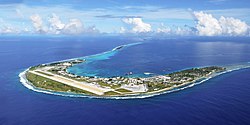
Passengers may disembark and reboard at each stop or remain on the Island Hopper with the exception of Kwajalein, where passengers are prohibited from leaving the aircraft unless they have prior authorization from the U.S. government, as the atoll is an active military installation served via Bucholz Army Airfield. Photography and videography there are also restricted.[3]
This page is based on this Wikipedia article Text is available under the CC BY-SA 4.0 license; additional terms may apply. Images, videos and audio are available under their respective licenses.