Related Research Articles

Railways: 0 km

The Ralik Chain is a chain of islands within the island nation of the Marshall Islands. Ralik means "sunset". It is west of the Ratak Chain. In 1999 the total population of the Ralik islands was 19,915. Christopher Loeak, who became President of the Marshall Islands in 2012, was formerly Minister for the Ralik Chain.

Ebeye is the most populous island of Kwajalein Atoll in the Marshall Islands, as well as the center for Marshallese culture in the Ralik Chain of the archipelago. Settled on 80 acres of land, it has a population of more than 15,000. Over 50% of the population is estimated to be under the age of 18.
Rongelap AtollRONG-gə-lap is a coral atoll of 61 islands in the Pacific Ocean, and forms a legislative district of the Ralik Chain of the Marshall Islands. Its total land area is 8 square miles (21 km2). It encloses a lagoon with an area of 1,000 square miles (2,600 km2). It is historically notable for its close proximity to US hydrogen bomb tests in 1954, and was particularly devastated by fallout from the Castle Bravo test. The population was forcibly removed from Rongelap following the test due to high radiation levels, and later studied due to their exposure to radiation. However, according to the most recent census in 2011 it has begun to recover with about eighty people living on the atoll.

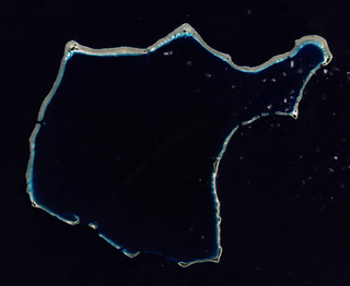
Rongerik Atoll or Rongdrik Atoll is a coral atoll of 17 islands in the Pacific Ocean, and is located in the Ralik Chain of the Marshall Islands, approximately 200 kilometers (120 mi) east of Bikini Atoll. Its total land area is only 1.68 square kilometers (0.65 sq mi), but it encloses a lagoon of 144 square kilometers (56 sq mi).

Air Marshall Islands is an airline based in Majuro, Marshall Islands. It is the flag carrier of the Marshall Islands, operating inter-island services in the Central Pacific. Its main base is Marshall Islands International Airport, Majuro.

Utirik Atoll or Utrik Atoll is a coral atoll of 10 islands in the Pacific Ocean, and forms a legislative district of the Ratak Chain of the Marshall Islands. Its total land area is only 2.4 square kilometers (0.94 sq mi), but it encloses a lagoon with an area of 57.7 square kilometers (22.29 sq mi). It is located approximately 47 kilometers (29 mi) east of Ujae Atoll. The population of Utirik Atoll is 300-400 as of 2020. it is one of the northernmost Marshall Islands with permanent habitation.

Ailinginae Atoll is an uninhabited coral atoll of 25 islands in the Pacific Ocean, on the northern end of the Ralik Chain of the Marshall Islands. Its total land area is only 2.8 square kilometers (1.1 sq mi), but it encloses a lagoon of 105.96 square kilometers (40.91 sq mi). It is located approximately 13 kilometers (8.1 mi) west of Rongelap Atoll. The landscape is low-lying with only the top 3 meters (9.8 ft) above sea level. The two entrances into the lagoon are 'Mogiri Pass' and 'Eniibukku Pass'. These are 1.45 and 0.48 kilometers wide respectively.

The Pacific Proving Grounds was the name given by the United States government to a number of sites in the Marshall Islands and a few other sites in the Pacific Ocean at which it conducted nuclear testing between 1946 and 1962. The U.S. tested a nuclear weapon on Bikini Atoll on June 30, 1946. This was followed by Baker on July 24, 1946.

Project 4.1 was the designation for a medical study and experimentation conducted by the United States of those residents of the Marshall Islands exposed to radioactive fallout from the March 1, 1954 Castle Bravo nuclear test at Bikini Atoll, which had an unexpectedly large yield. Government and mainstream historical sources point to the study being organized on March 6 or March 7, 1954, six days after the Bravo shot.

The following is an alphabetical list of topics related to the Marshall Islands.
Jeton Anjain was a Minister of Health and a senator of the Marshall Islands Parliament. He received the Goldman Environmental Prize in 1992, for his efforts to help people from the Rongelap Atoll, which was subject to nuclear contamination after the test of the Castle Bravo hydrogen bomb in 1954. In 1991, he and the Rongelap People were awarded the Right Livelihood Award for "their steadfast struggle against United States nuclear policy in support of their right to live on an unpolluted Rongelap island."
James Matayoshi is the mayor of Rongelap Atoll in the Marshall Islands. He was appointed as Rongelap's mayor in 1995 and has served as chairman of the Marshall Islands Ports Authority since 2008. As the mayor of Rongelap, Matayoshi was noted for his activism on calling for the United States government to render assistance to Marshall Islanders suffering from radiation sickness as a result of a series of nuclear tests carried out under Operation Castle in the 1950s.
Acropora rongelapensis is a species of branching scleractinian corals. It is only known from the lagoon of Rongelap Atoll in the Marshall Islands, Pacific Ocean.
Gogan may refer to:
Lijon Eknilang was a Marshallese activist and nuclear fallout survivor. Eknilang advocated on behalf of residents of Rongelap Atoll, who were victims of nuclear fallout stemming from the Castle Bravo hydrogen bomb test at Bikini Atoll in 1954.
Women in the Marshall Islands are women who live in or are from the Republic of the Marshall Islands, an island country that is politically a presidential republic in free association with the United States. Alternative appellations for these women are Marshallese women, Marshall Islander women, Marshalls women, and women in Rālik-Ratak.
Abacca Anjain-Maddison is a former Senator in the Marshall Islands and is now the Deputy Chief Secretary of the country. She is known as a campaigner against nuclear weapons and nuclear testing and in support of greater efforts by the United States to clean up islands it used for nuclear testing.

Naval Base Marshall Islands were United States Navy advance bases built on the Marshall Islands during World War II to support the Pacific War efforts. The bases were built by US Navy after the Marshall Islands campaign that captured the islands from the Empire of Japan. By February 1944 the United States Armed Forces had captured the islands. Most of the airfields and other facilities Japan had built were destroyed in allied bombing raids and naval bombardment. US Navy Seabee Construction Battalions arrived as soon as the area was secured and remove the debris. The Seabees quickly repaired, built and improved the airfield/runways and seaport. Seabees often worked around the clock to get airfields operational so that fighter aircraft and bombers could start operating. The bases were used for staging upcoming campaigns and for repair.
References
- ↑ "RNP - Rongelap Island, Marshall Islands - Rongelap Airport". Great Circle Mapper. Retrieved 2009-11-16.
Marshall Islands articles | |||||||
|---|---|---|---|---|---|---|---|
| History | |||||||
| Geography |
| ||||||
| Politics |
| ||||||
| Economy | |||||||
| Culture |
| ||||||
| |||||||