Kwajalein Atoll is part of the Republic of the Marshall Islands (RMI). The southernmost and largest island in the atoll is named Kwajalein Island, which its majority English-speaking residents often use the shortened name, Kwaj. The total land area of the atoll amounts to just over 6 square miles (16 km2). It lies in the Ralik Chain, 2,100 nautical miles southwest of Honolulu, Hawaii.

Bikini Atoll, known as Eschscholtz Atoll between the 19th century and 1946, is a coral reef in the Marshall Islands consisting of 23 islands surrounding a 229.4-square-mile (594.1 km2) central lagoon. The atoll is at the northern end of the Ralik Chain, approximately 530 miles (850 km) northwest of the capital Majuro.

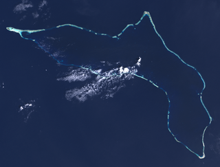
Enewetak Atoll is a large coral atoll of 40 islands in the Pacific Ocean and with its 296 people forms a legislative district of the Ralik Chain of the Marshall Islands. With a land area total less than 5.85 square kilometers (2.26 sq mi), it is no higher than 5 meters (16.4 ft) and surrounds a deep central lagoon, 80 kilometers (50 mi) in circumference. It is the second-westernmost atoll of the Ralik Chain and is 305 kilometers (190 mi) west from Bikini Atoll.

Kili Island or Kili Atoll is a small, 81 hectares island located in the Marshall Islands in the Pacific Ocean. As of 2021, 415 people lived on the island, many of whom were descended from islanders who originally lived on Bikini Atoll. They were relocated when they agreed to let the U.S. government temporarily use Bikini for nuclear testing in 1945, which they were told was of great importance to humankind, though it is sometimes considered a forced relocation. Kili Island became their home after two prior relocations failed. The island does not have a natural lagoon and cannot produce enough food to enable the islanders to be self-sufficient. It is part of the legislative district of the Ralik Chain of the Marshall Islands. The island is approximately 48 kilometers (30 mi) southwest of Jaluit. It is a good sized island for the Marshall Islands, but it is not an atoll with a lagoon.

Bucholz Army Airfield is a United States Army airfield located on Kwajalein Atoll, Marshall Islands. Its position is ideal for refueling during trans-Pacific flights, and the airport is available to civilians through Air Marshall Islands and United Airlines.

Marshall Islands International Airport, also known as Amata Kabua International Airport, is located in the western part of Rairok on the south side of Majuro Atoll, the capital of the Republic of the Marshall Islands. The airport was built during World War II (1943) on Anenelibw and Lokojbar islets. It replaced Majuro Airfield, a coral-surfaced airstrip at Delap Island near the eastern end of Majuro Atoll that had been originally constructed by Japanese occupation forces in 1942.
Taroa is an island in the east of Maloelap Atoll in the Marshall Islands. During World War II, it was the site of a major Japanese airfield. The airfield was destroyed near the close of World War II, and parts of the base and its ruins are still visible all over the island.
Jaluit Airport is a public use airstrip located one nautical mile (1.85 km) southwest of the village of Jabor on Jaluit Atoll, Marshall Islands. This airstrip is assigned the location identifier N55 by the FAA and UIT by the IATA.
Mejit Airport is a public use airstrip on Mejit Island, Marshall Islands. This airstrip is assigned the location identifier Q30 by the FAA and MJB by the IATA.
Mili Airport is a public use airstrip in the village of Mili on Mili Atoll, Marshall Islands. This airstrip is assigned the location identifier 1Q9 by the FAA and MIJ by the IATA.
Namorik Airport is a public use airstrip located at Namdrik on Namdrik Atoll, Marshall Islands. This airstrip is assigned the location identifier 3N0 by the FAA and NDK by the IATA.
Rongelap Airport is a public use airstrip at Rongelap on Rongelap Atoll, Marshall Islands.
Utirik Airport is a public use airstrip on Utirik Island in Utirik Atoll, Marshall Islands. This airstrip is assigned the location identifier 03N by the FAA and UTK by the IATA.
BII, Bii, bii, may refer to:

Kaven is a small island in the Maloelap Atoll in the Republic of the Marshall Islands. Situated at the northwesternmost tip of the atoll, it is the largest island and one of the few inhabited ones on the atoll. Together with a few other small islands, it forms part of the "outer islands" of the Marshalls. The island is located to the east of the Likiep Atoll, between Jeltonet in the southwest and Anejaej in the northwest. The southwesternmost tip of the island is called Anenemmwaan also. The region is uninhabited.

The following is an alphabetical list of topics related to the Marshall Islands.

French Frigate Shoals Airport is a private use airport on Tern Island in French Frigate Shoals, a coral atoll, in Hawaii, United States. It is owned by the United States Fish and Wildlife Service, as part of the Hawaiian Islands National Wildlife Refuge.
Ine Airport is a public use airstrip located in the village of Ine on Arno Atoll, Marshall Islands. This airstrip is assigned the location identifier N20 by the FAA and IMI by the IATA.
Tinak Airport,, is a public use airstrip located in the village of Tinak on Arno Atoll, Marshall Islands.

Nuclear testing at Bikini Atoll consisted of the detonation of 23 nuclear weapons by the United States between 1946 and 1958 on Bikini Atoll in the Marshall Islands. Tests occurred at 7 test sites on the reef itself, on the sea, in the air, and underwater. The test weapons produced a combined yield of about 77 Mt of TNT in explosive power. After the inhabitants agreed to a temporary evacuation, to allow nuclear testing on Bikini, which they were told was of great importance to humankind, two nuclear weapons were detonated in 1946. About ten years later, additional tests with thermonuclear weapons in the late 1950s were also conducted. The first thermonuclear explosion was much more powerful than expected, and created a number of issues, but did demonstrate the dangers of such devices.
