Enejit Airport | |
|---|---|
| Summary | |
| Airport type | Public |
| Serves | Enejit, Mili Atoll, Marshall Islands |
| Coordinates | 06°02′25″N171°59′04″E / 6.04028°N 171.98444°E |
 | |
Enejit Airport is a public use airstrip at Enejit on Mili Atoll, Marshall Islands. [1]
Enejit Airport | |
|---|---|
| Summary | |
| Airport type | Public |
| Serves | Enejit, Mili Atoll, Marshall Islands |
| Coordinates | 06°02′25″N171°59′04″E / 6.04028°N 171.98444°E |
| | |
Enejit Airport is a public use airstrip at Enejit on Mili Atoll, Marshall Islands. [1]
| Airlines | Destinations |
|---|---|
| Air Marshall Islands | Majuro |

Heathrow Airport, called London Airport until 1966, and now known as London Heathrow, is the main international airport serving London, the capital and most populous city of England and the United Kingdom. It is the largest of the six international airports in the London airport system. The airport is owned and operated by Heathrow Airport Holdings. In 2023, Heathrow was the busiest airport in Europe, the fourth-busiest airport in the world by passenger traffic and the second-busiest airport in the world by international passenger traffic. As of 2023, Heathrow is the airport with the most international connections in the world.
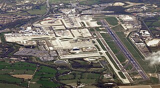
Los Angeles International Airport is the primary international airport serving Los Angeles and its surrounding metropolitan area, in the U.S. state of California. LAX is located in the Westchester neighborhood of the city of Los Angeles, 18 miles southwest of Downtown Los Angeles, with the commercial and residential areas of Westchester to the north, the city of El Segundo to the south, and the city of Inglewood to the east. LAX is the closest airport to the Westside and the South Bay.

An airport is an aerodrome with extended facilities, mostly for commercial air transport. They usually consist of a landing area, which comprises an aerially accessible open space including at least one operationally active surface such as a runway for a plane to take off and to land or a helipad, and often includes adjacent utility buildings such as control towers, hangars and terminals, to maintain and monitor aircraft. Larger airports may have airport aprons, taxiway bridges, air traffic control centres, passenger facilities such as restaurants and lounges, and emergency services. In some countries, the US in particular, airports also typically have one or more fixed-base operators, serving general aviation.

John F. Kennedy International Airport is a major international airport serving New York City and its metropolitan area, in the United States. The airport is located in Queens, New York City. It is the busiest of the seven airports in the New York airport system, the sixth-busiest airport in the United States, and the busiest international commercial airport in North America. The airport, which covers 5,200 acres (2,104 ha), is the largest in the New York metropolitan area.
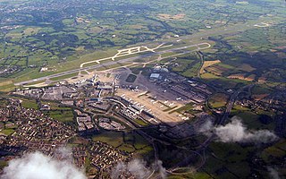
London Gatwick, also known as Gatwick Airport, is the secondary international airport serving London, England. It is located near Crawley, West Sussex, England 29.5 miles (47.5 km) south of Central London. In 2022, Gatwick was the second-busiest airport by total passenger traffic in the UK, after Heathrow Airport, and was the 8th-busiest in Europe by total passenger traffic. It covers a total area of 674 hectares.

Indira Gandhi International Airport is the primary international airport serving New Delhi, the capital of India, and the National Capital Region (NCR). The airport, spread over an area of 5,106 acres (2,066 ha), is situated in Palam, Delhi, 15 km (9.3 mi) southwest of the New Delhi Railway Station and 16 km (9.9 mi) from New Delhi city centre.

An IATA airport code, also known as an IATA location identifier, IATA station code, or simply a location identifier, is a three-letter geocode designating many airports and metropolitan areas around the world, defined by the International Air Transport Association (IATA). The characters prominently displayed on baggage tags attached at airport check-in desks are an example of a way these codes are used.

Hartsfield–Jackson Atlanta International Airport is the primary international airport serving Atlanta and its surrounding metropolitan area, in the U.S. state of Georgia. The airport is located 10 mi south of the Downtown Atlanta district. It is named after former Atlanta mayors William B. Hartsfield and Maynard Jackson. The airport covers 4,700 acres of land and has five parallel runways which are aligned in an east-west direction. There are three runways that are 9,000 feet (2,743 m) long, one runway that is 10,000 feet (3,048 m) long, and the longest runway at ATL measures 12,390 feet (3,776 m) long, which can handle the Airbus A380. Since 1998, Hartsfield-Jackson has been the world's busiest airport by passenger traffic. In 2023, the airport served over 104.6 million passengers, the most of any airport in the world. Hartsfield-Jackson is also the world's busiest airport by aircraft movements.

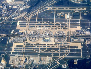
Chicago O'Hare International Airport is a major international airport serving Chicago, Illinois, United States, located on the city's Northwest Side, approximately 17 miles (27 km) northwest of the Loop business district. Operated by the Chicago Department of Aviation and covering 7,627 acres. O'Hare has non-stop flights to 249 destinations in North America, South America, the Caribbean, Europe, Africa, Asia, the Middle East and the North Atlantic region as of Summer 2024. As of 2024, O'Hare is considered the most connected airport in the US, and 5th most connected airport in the world. It is also the United States' 4th busiest airport, and 7th biggest airport.

Hong Kong International Airport is an international airport on the island of Chek Lap Kok in western Hong Kong. The airport is also referred to as Chek Lap Kok International Airport or Chek Lap Kok Airport, to distinguish it from its predecessor, the former Kai Tak Airport.
Dallas Fort Worth International Airport is the primary international airport serving the Dallas–Fort Worth metroplex and the North Texas region, in the U.S. state of Texas.
Denver International Airport is an international airport in the Western United States, primarily serving metropolitan Denver, Colorado, as well as the greater Front Range Urban Corridor. At 33,531 acres, it is the largest airport in the Western Hemisphere by land area and the second largest on Earth, behind King Fahd International Airport. Runway 16R/34L, with a length of 16,000 feet, is the longest public use runway in North America and the seventh longest on Earth. The airport is 25 miles (40 km) driving distance northeast of Downtown Denver, 19 miles (31 km) farther than the former Stapleton International Airport which DEN replaced; the airport is actually closer to the City of Aurora than central Denver, and many airport-related services, such as hotels, are located in Aurora.
Manchester Airport is an international airport in Ringway, Manchester, England, 7 miles (11 km) south-west of Manchester city centre. In 2022, it was the third busiest airport in the United Kingdom in terms of passengers and the 19th busiest airport in Europe in 2023, with 28.1 million passengers served.

The ICAOairport code or location indicator is a four-letter code designating aerodromes around the world. These codes, as defined by the International Civil Aviation Organization and published quarterly in ICAO Document 7910: Location Indicators, are used by air traffic control and airline operations such as flight planning. ICAO codes are also used to identify other aviation facilities such as weather stations, international flight service stations or area control centers, whether or not they are located at airports. Flight information regions are also identified by a unique ICAO-code.
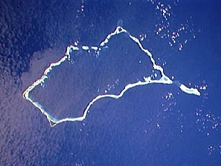
Mili Atoll is a coral atoll of 92 islands in the Pacific Ocean, and forms a legislative district of the Ratak Chain of the Marshall Islands. It is located approximately 78 kilometers (48 mi) southeast of Arno. Its total land area is 14.9 square kilometers (5.8 sq mi) making it the second largest of the Marshall Islands after Kwajalein.

Toronto Pearson International Airport is an international airport located in Mississauga, Ontario, Canada. It is the main airport serving Toronto, its metropolitan area, and the surrounding region known as the Golden Horseshoe. The airport is named in honour of Lester B. Pearson, who served as the 14th Prime Minister of Canada (1963–1968) and received the Nobel Peace Prize in 1957 for his humanitarian work in peacekeeping.
Kempegowda International Airport is an international airport serving Bengaluru, the capital of the Indian state of Karnataka. Spread over 4,000 acres (1,600 ha), it is located about 35 km (22 mi) north of the city near the suburb of Devanahalli. It is owned and operated by Bengaluru International Airport Limited (BIAL), a public–private consortium. The airport opened in May 2008 as an alternative to increased congestion at HAL Airport, the original primary commercial airport serving the city. It is named after Kempe Gowda I, the founder of Bangalore. Kempegowda International Airport became Karnataka's first fully solar powered airport, developed by CleanMax Solar.
Singapore Changi Airport is a major international airport that serves Singapore, and is one of the largest transportation hubs in Asia. More than 100 airlines operate from the airport, with flights to destinations in Asia, Oceania, Africa, Europe, the Middle East, and North America.
Marshall Islands articles | |||||||
|---|---|---|---|---|---|---|---|
| History | |||||||
| Geography |
| ||||||
| Politics |
| ||||||
| Economy | |||||||
| Culture |
| ||||||
| |||||||
| | This article about an Oceanian airport is a stub. You can help Wikipedia by expanding it. |