
Railways: 0 km
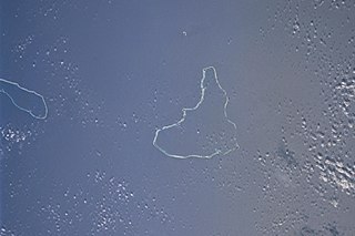
Ailinglaplap or Ailinglapalap is a coral atoll of 56 islands in the Pacific Ocean, and forms a legislative district of the Ralik Chain in the Marshall Islands. It is located 152 kilometres (94 mi) northwest of Jaluit Atoll. Its total land area is only 14.7 square kilometers (5.7 sq mi), but it encloses a lagoon of 750 square kilometers (290 sq mi). The economy of the atoll is dominated by coconut plantations. The population of the atoll was 1,175 in 2021. Jabat Island is located off the coast of Ailinglaplap Atoll. The former president of the Marshall Islands, Kessai Note, was born on Jeh Island, Ailinglaplap Atoll.

Cocos (Keeling) Islands Airport is an airport serving the Cocos (Keeling) Islands, a territory of Australia located in the Indian Ocean. The airport is on West Island, one of the South Keeling Islands and capital of the territory.
Airok Airport is a public use airstrip at Airok on Ailinglaplap Atoll, Marshall Islands.
Aur Airport is a public use airstrip at Aur on Aur Atoll, Marshall Islands. This airstrip is assigned the location identifier AUL by the IATA.
Bikini Atoll Airport, also known as Enyu Airfield, is a public use airstrip at Enyu on Bikini Atoll, Marshall Islands. This airstrip is assigned the location identifier BII by the IATA. The airstrip enables access to diving and shipwrecks.
Ebon Airport is a public use airstrip at Ebon on Ebon Atoll, Marshall Islands. This airstrip is assigned the location identifier EBO by the IATA.
Jaluit Airport is a public use airstrip located one nautical mile (1.85 km) southwest of the village of Jabor on Jaluit Atoll, Marshall Islands. This airstrip is assigned the location identifier N55 by the FAA and UIT by the IATA.
Kili Airport is a public use airstrip on Kili Island, Marshall Islands. This airstrip is assigned the location identifier Q51 by the FAA and KIO by the IATA.
Mejit Airport is a public use airstrip on Mejit Island, Marshall Islands. This airstrip is assigned the location identifier Q30 by the FAA and MJB by the IATA.
Mili Airport is a public use airstrip in the village of Mili on Mili Atoll, Marshall Islands. This airstrip is assigned the location identifier 1Q9 by the FAA and MIJ by the IATA.
Namorik Airport is a public use airstrip located at Namdrik on Namdrik Atoll, Marshall Islands. This airstrip is assigned the location identifier 3N0 by the FAA and NDK by the IATA.
Utirik Airport is a public use airstrip on Utirik Island in Utirik Atoll, Marshall Islands. This airstrip is assigned the location identifier 03N by the FAA and UTK by the IATA.
Woja Airport is a public use airstrip at Woja on Ailinglaplap Atoll, Marshall Islands. This airstrip is assigned the location identifier WJA by the IATA.
Ailuk Airport is a public use airstrip at Ailuk on Ailuk Atoll, Marshall Islands.

Kaven is a small island in the Maloelap Atoll in the Republic of the Marshall Islands. Situated at the northwesternmost tip of the atoll, it is the largest island and one of the few inhabited ones on the atoll. Together with a few other small islands, it forms part of the "outer islands" of the Marshalls. The island is located to the east of the Likiep Atoll, between Jeltonet in the southwest and Anejaej in the northwest. The southwesternmost tip of the island is called Anenemmwaan also. The region is uninhabited.
Ine Airport is a public use airstrip located in the village of Ine on Arno Atoll, Marshall Islands. This airstrip is assigned the location identifier N20 by the FAA and IMI by the IATA.
Tinak Airport,, is a public use airstrip located in the village of Tinak on Arno Atoll, Marshall Islands.
