
The Marshall Islands, officially the Republic of the Marshall Islands, is an island country west of the International Date Line and north of the equator in the Micronesia region in the Northwestern Pacific Ocean.

Railways: 0 km
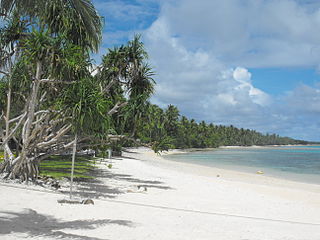
Majuro is the capital and largest city of the Marshall Islands. It is also a large coral atoll of 64 islands in the Pacific Ocean. It forms a legislative district of the Ratak (Sunrise) Chain of the Marshall Islands. The atoll has a land area of 9.7 square kilometers (3.7 sq mi) and encloses a lagoon of 295 square kilometers (114 sq mi). As with other atolls in the Marshall Islands, Majuro consists of narrow land masses. It has a tropical trade wind climate, with an average temperature of 27 °C (81 °F).

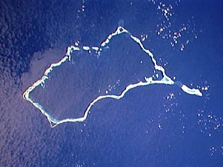
Wotje Atoll is a coral atoll of 75 islands in the Pacific Ocean, and forms a legislative district of the Ratak Chain of the Marshall Islands.
Mili Atoll is a coral atoll of 92 islands in the Pacific Ocean, and forms a legislative district of the Ratak Chain of the Marshall Islands. It is located approximately 78 kilometers (48 mi) southeast of Arno. Its total land area is 14.9 square kilometers (5.8 sq mi) making it the second largest of the Marshall Islands after Kwajalein.

Jaluit Atoll is a large coral atoll of 91 islands in the Pacific Ocean and forms a legislative district of the Ralik Chain of the Republic of the Marshall Islands. Its total land area is 11.34 square kilometers (4.38 sq mi), and it encloses a lagoon with an area of 690 square kilometers (270 sq mi). Most of the land area is on the largest islet (motu) of Jaluit (10.4 km2). Jaluit is approximately 220 kilometers (140 mi) southwest of Majuro. Jaluit Atoll is a designated conservation area and Ramsar Wetland.
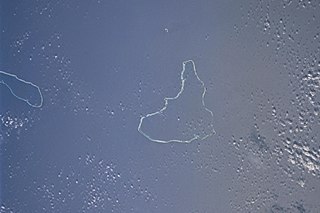
The Maloelap Atoll is a coral atoll of 71 islands in the Pacific Ocean, and forms a legislative district of the Ratak Chain of the Marshall Islands. Its land area is only 9.8 square kilometers (3.8 sq mi), but that encloses a lagoon of 972 square kilometers (375 sq mi). It is located 18 kilometers (11 mi) north of the atoll of Aur. The population of the atoll was 395 at the 2021 census.
Ailinglaplap or Ailinglapalap is a coral atoll of 56 islands in the Pacific Ocean, and forms a legislative district of the Ralik Chain in the Marshall Islands. It is located 152 kilometres (94 mi) northwest of Jaluit Atoll. Its total land area is only 14.7 square kilometers (5.7 sq mi), but it encloses a lagoon of 750 square kilometers (290 sq mi). The economy of the atoll is dominated by coconut plantations. The population of the atoll was 1,175 in 2021. Jabat Island is located off the coast of Ailinglaplap Atoll. The former president of the Marshall Islands, Kessai Note, was born on Jeh Island, Ailinglaplap Atoll.
Roi-Namur is an island in the north part of the Kwajalein Atoll in the Marshall Islands. Today it is a major part of the Ronald Reagan Ballistic Missile Defense Test Site, hosting several radar systems used for tracking and characterizing missile reentry vehicles (RV) and their penetration aids (penaids). A flooding event by wave overtopping made national news in the United States, with dramatic footage of water bursting through a door.

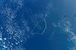
Namu Atoll is a coral atoll of 54 islands in the Pacific Ocean, and forms a legislative district of the Ralik Chain of the Marshall Islands. Its total land area is only 6.27 square kilometers (2.42 sq mi), but that encloses a lagoon of 397 square kilometers (153 sq mi). It is located approximately 62 kilometers (39 mi) south-southwest of Kwajalein Atoll.

Cambridge City Airport — previously Marshall Airport Cambridge UK — is a regional airport in Cambridgeshire, England. It is located on the eastern outskirts of Cambridge, south of Newmarket Road and west of the village of Teversham, 1.5 NM from the centre of Cambridge and approximately 50 mi (80 km) from London.

Mejit is an island in the Pacific Ocean, and forms a legislative district of the Ratak Chain of the Marshall Islands. Unlike most of the other islands of the Marshall Islands, Mejit is a stony island rather than a coral atoll, although it is surrounded by a fringing coral reef enclosing a narrow lagoon. It is located east of the main line of the Ratak chain, approximately 110 kilometers (68 mi) northeast from Wotje. The population was 230 at the 2021 census.

Bonriki International Airport is an international airport in Kiribati, serving as the main gateway to the country. It is located in its capital, South Tarawa, which is a group of islets in the atoll of Tarawa in the Gilbert Islands, precisely on Bonriki.

Bucholz Army Airfield is a United States Army airfield located on Kwajalein Atoll, Marshall Islands. Its position is ideal for refueling during trans-Pacific flights, and the airport is available to civilians through Air Marshall Islands and United Airlines.

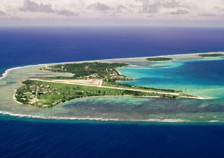
Marshall Islands International Airport, also known as Amata Kabua International Airport, is located in the western part of Rairok on the south side of Majuro Atoll, the capital of the Republic of the Marshall Islands. The airport was built during World War II (1943) on Anenelibw and Lokojbar islets. It replaced Majuro Airfield, a coral-surfaced airstrip at Delap Island near the eastern end of Majuro Atoll that had been originally constructed by Japanese occupation forces in 1942.

Kingscote Airport is located 6.5 nautical miles southwest of Kingscote, South Australia, the main town on Kangaroo Island, in the locality of Cygnet River. The airport is the sole airport for Kangaroo Island. The airport is served by regular public transport and many charter flights. The airport is managed by the Kangaroo Island Council, which has operated the airport since 16 June 1983.

Kaven is a small island in the Maloelap Atoll in the Republic of the Marshall Islands. Situated at the northwesternmost tip of the atoll, it is the largest island and one of the few inhabited ones on the atoll. Together with a few other small islands, it forms part of the "outer islands" of the Marshalls. The island is located to the east of the Likiep Atoll, between Jeltonet in the southwest and Anejaej in the northwest. The southwesternmost tip of the island is called Anenemmwaan also. The region is uninhabited.
This page contains the lists of airports in Oceania by country, grouped by region. The lists include both military air bases and civilian airports.

Republic of Marshall Islands Public School System (PSS) is the public school system of the Marshall Islands, headquartered in Majuro. It was established in November 2013 by Public Law 2013-23.
