Johnston Atoll is an unincorporated territory of the United States, under the jurisdiction of the United States Air Force (USAF). The island is closed to public entry, and limited access for management needs is only granted by a letter of authorization from the USAF. A special use permit is also required from the United States Fish and Wildlife Service (USFWS) to access the island by boat or enter the waters surrounding the island, which are designated as a National Wildlife Refuge and part of the Pacific Remote Islands Marine National Monument. The Johnston Atoll National Wildlife Refuge extends from the shore out to 12 nautical miles, continuing as part of the National Wildlife Refuge System out to 200 nautical miles. The Pacific Remote Islands Marine National Monument extends from the shore out to 200 nautical miles.

Palmyra Atoll, also referred to as Palmyra Island, is one of the Northern Line Islands. It is located almost due south of the Hawaiian Islands, roughly one-third of the way between Hawaii and American Samoa. North America is about 3,300 miles northeast and New Zealand the same distance southwest, placing the atoll at the approximate center of the Pacific Ocean. The land area is 4.6 sq mi (12 km2), with about 9 miles of sea-facing coastline and reef. There is one boat anchorage, known as West Lagoon, accessible from the sea by a narrow artificial channel and an old airstrip; during WW2, it was turned into a Naval Air Station for several years and used for training and refueling. It was shelled by a submarine in December 1941 but was not the site of a major battle.

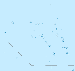
Bikini Atoll, known as Eschscholtz Atoll between the 19th century and 1946, is a coral reef in the Marshall Islands consisting of 23 islands surrounding a 229.4-square-mile (594.1 km2) central lagoon. The atoll is at the northern end of the Ralik Chain, approximately 530 miles (850 km) northwest of the capital Majuro.

Enewetak Atoll is a large coral atoll of 40 islands in the Pacific Ocean and with its 296 people forms a legislative district of the Ralik Chain of the Marshall Islands. With a land area total less than 5.85 square kilometers (2.26 sq mi), it is no higher than 5 meters (16.4 ft) and surrounds a deep central lagoon, 80 kilometers (50 mi) in circumference. It is the second-westernmost atoll of the Ralik Chain and is 305 kilometers (190 mi) west from Bikini Atoll.
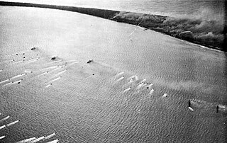
The Battle of Eniwetok was a battle of the Pacific campaign of World War II, fought from 17 to 23 February 1944 on Enewetak Atoll in the Marshall Islands. The invasion of Eniwetok followed the American success in the Battle of Kwajalein to the southeast. Capture of Eniwetok would provide an airfield and harbor to support attacks on the Mariana Islands to the northwest. The operation was officially known as "Operation Catchpole" and was a three-phase operation involving the invasion of the three main islands in the Enewetak Atoll.

The Hunters Point Naval Shipyard was a United States Navy shipyard in San Francisco, California, located on 638 acres (258 ha) of waterfront at Hunters Point in the southeast corner of the city.

The Battle of Kwajalein was fought as part of the Pacific campaign of World War II. It took place 31 January – 3 February 1944, on Kwajalein Atoll in the Marshall Islands. Employing the hard-learned lessons of the Battle of Tarawa, the United States launched a successful twin assault on the main islands of Kwajalein in the south and Roi-Namur in the north. The Japanese defenders put up stiff resistance, although outnumbered and under-prepared. The determined defense of Roi-Namur left only 51 survivors of an original garrison of 3,500.

The Pacific Proving Grounds was the name given by the United States government to a number of sites in the Marshall Islands and a few other sites in the Pacific Ocean at which it conducted nuclear testing between 1946 and 1962. The U.S. tested a nuclear weapon on Bikini Atoll on June 30, 1946. This was followed by Baker on July 24, 1946.
The Gilbert and Marshall Islands campaign were a series of battles fought from August 1942 through February 1944, in the Pacific theatre of World War II between the United States and Japan. They were the first steps of the drive across the Central Pacific by the United States Pacific Fleet and Marine Corps. The purpose was to establish airfields and naval bases that would allow air and naval support for upcoming operations across the Central Pacific. Operation Galvanic and Operation Kourbash were the code names for the Gilberts campaign that included the seizures of Tarawa and Makin, during the Battle of Tarawa on 20–23 November 1943 and the Battle of Makin on 20–24 November 1943. Operation Flintlock and Operation Catchpole were aimed at capturing Japanese bases at Kwajalein, Eniwetok, and Majuro in the Marshall Islands.

Bucholz Army Airfield is a United States Army airfield located on Kwajalein Atoll, Marshall Islands. Its position is ideal for refueling during trans-Pacific flights, and the airport is available to civilians through Air Marshall Islands and United Airlines.

Johnston Island Air Force Base is a former United States Air Force base on the Johnston Atoll in the United States Minor Outlying Islands, in the Pacific Ocean several hundred kilometers southwest of Hawaii. After its closure, it briefly operated as Johnston Atoll Airport, until that also closed in 2005.

Nuclear testing at Bikini Atoll consisted of the detonation of 23 nuclear weapons by the United States between 1946 and 1958 on Bikini Atoll in the Marshall Islands. Tests occurred at 7 test sites on the reef itself, on the sea, in the air, and underwater. The test weapons produced a combined yield of about 77-78.6 Mt of TNT in explosive power. After the inhabitants agreed to a temporary evacuation, to allow nuclear testing on Bikini, which they were told was of great importance to humankind, two nuclear weapons were detonated in 1946. About ten years later, additional tests with thermonuclear weapons in the late 1950s were also conducted. The first thermonuclear explosion was much more powerful than expected, and created a number of issues, but did demonstrate the dangers of such devices.

Typhoon Alice was an unusual West Pacific tropical cyclone that caused extensive damage in the Marshall Islands in January 1979. The first tropical cyclone and the first typhoon of the 1979 Pacific typhoon season, Alice formed on December 31, 1978, from a tropical disturbance at both an atypically low latitude near the equator and during a time of year climatologically unfavorable for tropical cyclogenesis. The system strengthened as it tracked northwest, reaching tropical storm strength on January 1, 1979. Alice then began to move erratically through the Marshall Islands, causing heavy rainfall and gusty winds that destroyed crops throughout the archipelago. Significant damage occurred in Majuro and Enewetak Atoll, where gusts of 80 mph (130 km/h) were reported and one person was injured. Nuclear cleanup operations on Enewetak in the wake of postwar nuclear tests there were disrupted, with repair of cleanup facilities lasting several months. The damage toll was estimated at between US$50,000–$500,000.

US Naval Advance Bases were built globally by the United States Navy during World War II to support and project U.S. naval operations worldwide. A few were built on Allied soil, but most were captured enemy facilities or completely new. Advance bases provided the fleet with support to keep ships tactically available with repair and supply depots of facilities, rather than return them to the continental United States. Before Japan declared war on the United States the U.S. Navy had a single fleet-sized advanced base in the Territory of Hawaii at Naval Station Pearl Harbor. During the war the U.S. Navy Seabees built over 400 advance bases categorized by size. Naval bases were either Lions or Cubs while airfields were either Oaks or Acorns. Lions and Oaks were major facilities while Cubs and Acorns were minor. PT Boats typically would get a Cub and airfields with single runways were Acorns. The larger bases could provide refueling and overhaul; loading of troopship and cargo ships; and preparing amphibious assault ships. Some became major repair depots. The Seabees developed auxiliary floating drydocks were able to repair battle damage and do regular maintenance in the field saving ships trans-pacific trips for repair. A few bases also were developed to be R and R for all U.S. personnel. Most Advance Bases were built by the US Navy's Seabees in Naval Construction Battalions (CBs). At the start of the war civilian contractors were employed in construction. The Seabees in World War II built most of the airfields used by the United States Army Air Forces and United States Marine Corps, as they had the ships and cranes needed to transport the vast amount of equipment needed at the advance bases. The US Army and United States Coast Guard also operated out of many of these facilities. Seabees could build new or repair damaged runways, and with advancements in heavy bomber technology lengthen runways as needed. A few Naval Advance Bases were built for the Korean War and Vietnam War.

Naval Base Funafuti was a naval base built by the United States Navy in 1942 to support the World War II effort. The base was located on the Island of Funafuti of the Ellice Islands in the Western Pacific Ocean. The island is now Tuvalu, an island country in the Polynesian. After the surprise attack on Naval Station Pearl Harbor on December 7, 1941, the US Navy was in need of setting up more advance bases in the Pacific Ocean. At Naval Base Funafuti the Navy built a sea port, a small hospital, PT boat base, a seaplane base and an airbase. The United States Marine Corps landed on Funafuti on 2 October 1942 and on Nanumea and Nukufetau in August 1943. The Japanese had already occupied Tarawa and other islands in what is now Kiribati, but were delayed by the losses at the Battle of the Coral Sea.

Naval Base Gilbert Islands were naval bases built by the United States Navy in 1943 to support the World War II effort. The bases were located on in the Gilbert Islands in the Central Pacific Ocean. The bases were built as part of the many advance bases in the island-hopping campaign towards the Empire of Japan. The largest base was the Naval Base Tarawa. At Tarawa the Navy built a seaport, supply depots, a small ship repair depot, Carrier Aircraft Service Unit, seaplane base and two airbases. Construction started after the Battle of Tarawa ended on November 23, 1943, part of Operation Galvanic. The bases were built by the US Navy's Seabees, Naval Construction Battalions. After the war the bases were abandoned. Some of the airfields became civilian airports.

Naval Base Kwajalein was United States Navy base built on Kwajalein Atoll, in the Marshall Islands to support the World War II efforts in the Pacific War. The base was built after the Battle of Kwajalein ended 3 February 1944. The US Navy built airfields, a seaport and a craft repair depot on the captured islands. The base was part of the vast Naval Base Marshall Islands.

Naval Base Marshall Islands were United States Navy advance bases built on the Marshall Islands during World War II to support the Pacific War efforts. The bases were built by US Navy after the Marshall Islands campaign that captured the islands from the Empire of Japan. By February 1944 the United States Armed Forces had captured the islands. Most of the airfields and other facilities Japan had built were destroyed in allied bombing raids and naval bombardment. US Navy Seabee Construction Battalions arrived as soon as the area was secured and remove the debris. The Seabees quickly repaired, built and improved the airfield/runways and seaport. Seabees often worked around the clock to get airfields operational so that fighter aircraft and bombers could start operating. The bases were used for staging upcoming campaigns and for repair.
US Naval Base Carolines included a number of United States Navy bases on the Caroline Islands in the western Pacific Ocean, to the north of New Guinea during World War II. The bases were built to support the island hopping Pacific War efforts of the allied nations fighting the Empire of Japan.
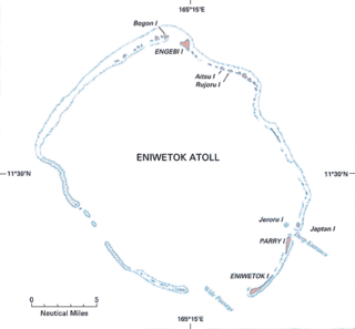
Naval Base Eniwetok was a major United States Navy base located at Enewetak Atoll in the Marshall Islands, during World War II. The base was built to support the island-hopping strategy used by allied nations fighting the Empire of Japan in the Pacific War. During 1944-5 Eniwetok was one of the busiest naval bases in the world with over 488 ships.