
Lae (German: Preußen-Reede, later Lehe) is the capital of Morobe Province and is the second-largest city in Papua New Guinea. It is located near the delta of the Markham River on the northern coast of Huon Gulf. It is at the start of the Highlands Highway, which is the main land transport corridor between the Highlands Region and the coast. Lae is the largest cargo port of the country and is the industrial hub of Papua New Guinea. The city is known as the Garden City and home of the Papua New Guinea University of Technology.

The Ralik Chain is a chain of islands within the island nation of the Marshall Islands. Ralik means "sunset". It is west of the Ratak Chain. In 1999 the total population of the Ralik islands was 19,915. Christopher Loeak, who became President of the Marshall Islands in 2012, was formerly Minister for the Ralik Chain.

Wotho Atoll is a coral atoll of 13 islands in the Pacific Ocean, and forms a legislative district of the Ralik Chain of the Marshall Islands. Its total land area is only 4.33 square kilometers (1.67 sq mi), but it encloses a lagoon of 94.92 square kilometers (36.65 sq mi). The name "Wotho" means either "entrance through the reef", or "island far away" according to different sources.
Ka Lae, also known as South Point, is the southernmost point of the Big Island of Hawaii and of the 50 United States. The Ka Lae area is registered as a National Historic Landmark District under the name South Point Complex. The area is also known for its strong ocean currents and winds and is the home of a wind farm.
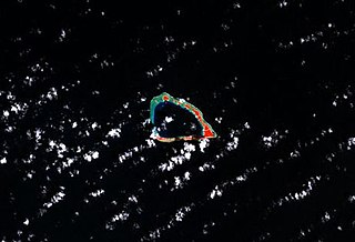
Lae Atoll is a coral atoll of 20 islands in the Pacific Ocean, and forms a legislative district of the Ralik Chain of the Marshall Islands. Its total land area is only 1.5 square kilometers (0.58 sq mi), but it encloses a lagoon with an area of 17.7 square kilometers (6.8 sq mi). It is located approximately 47 kilometers (29 mi) east of Ujae Atoll. The population of Lae Atoll was 133 in 2021. Its islands include Lae, Looj (Lotj), Bilalalon, Riblong (Ribon) and Lweijab (Lejab).

Ujae Atoll is a coral atoll of 15 islands in the Pacific Ocean, and forms a legislative district of the Ralik Chain of the Marshall Islands. Its total land area is only 1.86 square kilometers (0.72 sq mi), but it encloses a lagoon of 185.94 square kilometers (71.79 sq mi). It is located about 122 kilometers (76 mi) west of Kwajalein Atoll.
PNG Air is an airline based on the grounds of Jacksons International Airport, Port Moresby, Papua New Guinea. It operates scheduled domestic and international flights, as well as contract corporate charter work. Its main base is Jacksons International Airport.

Officially named Nadzab Tomodachi International Airport, Nadzab Airport is a regional airport located at Nadzab 42 kilometres (26 mi) outside Lae, Morobe Province, Papua New Guinea along the Highlands Highway. It is served by both private and regional aircraft with domestic flights. The airport replaced the Lae Airfield in 1977.

The Church of Jesus Christ of Latter-day Saints in the Marshall Islands refers to the Church of Jesus Christ of Latter-day Saints and its members in the Marshall Islands. As of 2022, there were 6,832 members in 13 congregations, making it the second largest body of LDS Church members in Micronesia, behind Kiribati. The Marshall Islands has the second most LDS Church members per capita in Micronesia, and the fourth most members per capita of any independent country in the world, behind Tonga, Samoa, and Kiribati.
Nadzab Village is in the Markham Valley, Morobe Province, Papua New Guinea on the Highlands Highway. Administratively, it is located in Gabsongkeg ward of Wampar Rural LLG. The Nadzab Airport is located East of Nadzab Village and was the site of the only Allied paratrooper assault in New Guinea on 5 September 1943.

Lae Airfield is a former World War II airfield and later, civilian airport located at Lae, Morobe Province, Papua New Guinea. The airport was closed in the 1980s, in favour of Lae Nadzab Airport, which was able to accommodate larger jet aircraft. The airport was also known as Lae Drome or Lae Aerodrome.

The following is an alphabetical list of topics related to the Marshall Islands.
This is a list of Imperial Japanese Navy bases and facilities

The Tenyo Maru was a 6,843-gross register ton passenger cargo ship built by Mitsubishi, Nagasaki for Toyo Kisen Kabushiki Kaisha in 1935. She was chartered to Mitsui and plied the New York route until she was requisitioned on 9 September 1941 by the Imperial Japanese Navy during World War II and converted at the Harima shipyard to a minelayer, which was completed on 31 October 1941.

Severe Tropical Storm Zelda was the last tropical cyclone of the 1991 Pacific typhoon season; it struck the Marshall Islands on November 28. The area of low pressure that eventually became Zelda formed near the International Date Line, and strengthened into a tropical depression on November 27. The Joint Typhoon Warning Center (JTWC) reported that the depression had reached tropical storm intensity near the Marshall Islands on November 28, thus naming it Zelda. On November 29, the storm quickly strengthened to 65 knots according to the JTWC, equivalent to a Category 1 typhoon on the Saffir–Simpson hurricane wind scale. It reached a peak of 80 kn according to the JTWC, and 60 kn according to the Japanese Meteorological Agency (JMA), with a barometric pressure of 975 hectopascals (28.8 inHg). Zelda weakened into a tropical storm on December 2, and then a tropical depression two days later. The JTWC discontinued warnings late on December 4, while the JMA declared the storm to be extratropical the next day and continued to track until it crossed the International Date Line again on December 7.

As the township of Lae, in Morobe Province, Papua New Guinea is a relatively new entity, the history of the Lae environs is much older.
This page contains the lists of airports in Oceania by country, grouped by region. The lists include both military air bases and civilian airports.

Republic of Marshall Islands Public School System (PSS) is the public school system of the Marshall Islands, headquartered in Majuro. It was established in November 2013 by Public Law 2013-23.
Kwajalein Atoll High School is a secondary school in Kwajalein, Marshall Islands. It is a part of the Marshall Islands Public School System.
