
Wotje Atoll is a coral atoll of 75 islands in the Pacific Ocean, and forms a legislative district of the Ratak Chain of the Marshall Islands.
The Maloelap Atoll is a coral atoll of 71 islands in the Pacific Ocean, and forms a legislative district of the Ratak Chain of the Marshall Islands. Its land area is only 9.8 square kilometers (3.8 sq mi), but that encloses a lagoon of 972 square kilometers (375 sq mi). It is located 18 kilometers (11 mi) north of the atoll of Aur. The population of the atoll was 395 at the 2021 census.
Ailinglaplap or Ailinglapalap is a coral atoll of 56 islands in the Pacific Ocean, and forms a legislative district of the Ralik Chain in the Marshall Islands. It is located 152 kilometres (94 mi) northwest of Jaluit Atoll. Its total land area is only 14.7 square kilometers (5.7 sq mi), but it encloses a lagoon of 750 square kilometers (290 sq mi). The economy of the atoll is dominated by coconut plantations. The population of the atoll was 1,175 in 2021. Jabat Island is located off the coast of Ailinglaplap Atoll. The former president of the Marshall Islands, Kessai Note, was born on Jeh Island, Ailinglaplap Atoll.
Arno Atoll is a coral atoll of 133 islands in the Pacific Ocean, and forms a legislative district of the Ratak Chain of the Marshall Islands. Its total land area is only 5 square miles (13 km2). Unlike most other atolls, Arno encloses three different lagoons, a large central one, and two smaller ones in the north and east. Its main lagoon encloses an area of 130.77 square miles (338.7 km2). At a distance of only 20 kilometers (12 mi), it is the closest atoll to the Marshall Islands capital, Majuro Atoll, and can be seen looking east from Majuro on a clear day at low tide. The population of Arno Atoll was 1,141 at the 2021 census. The most populous islets are Ajeltokrok, Kobjeltak, Rearlaplap, Langor and Tutu. The largest village is Ine, Arno.

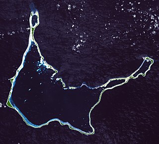
Wotho Atoll is a coral atoll of 13 islands in the Pacific Ocean, and forms a legislative district of the Ralik Chain of the Marshall Islands. Its total land area is only 4.33 square kilometers (1.67 sq mi), but it encloses a lagoon of 94.92 square kilometers (36.65 sq mi). The name "Wotho" means either "entrance through the reef", or "island far away" according to different sources.
Ailuk Atoll is a coral atoll of 57 islets in the Pacific Ocean, and forms a legislative district of the Ratak Chain of the Marshall Islands. It is located approximately 72 kilometers (45 mi) north from Wotje. Its total land area is only 5.4 square kilometers (2.1 sq mi), but it encloses a lagoon with an area of 177.45 square kilometers (68.51 sq mi). The major islets are: Ajelep, Aliej, Ailuk, Alkilwe, Barorkan, Biken, Enejabrok, Enejelar, Kapen and Marib. Most of the islets are on the eastern side of the atoll. The western and southern sides of the atoll have a nearly continuous submerged coral reef, with three main passes that lead into the lagoon: Erappu Channel, Marok Channel and Eneneman Channel on the west side.
Aur Atoll is a coral atoll of 42 islands in the Pacific Ocean, and forms a legislative district of the Ratak Chain of the Marshall Islands. Its total land area is only 15 square kilometers (5.6 sq mi), but it encloses a lagoon with an area of 620 square kilometers (240 sq mi). It is located south of Maloelap Atoll. The population of Aur Atoll was 317 in 2021.
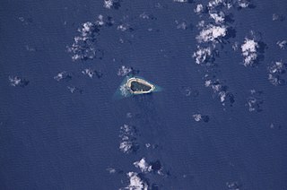
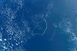
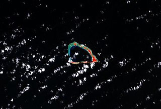
Jabat Island is an island in the Pacific Ocean, and forms a legislative district of the Ralik Chain of the Marshall Islands. Its total land area is only 0.6 square kilometers (0.23 sq mi), and has a length of 1.2 kilometers (0.75 mi). It is located 12 kilometers (7.5 mi) from Ailinglapalap Atoll. Unlike most of the other islands in the Marshall Islands, Jabat Island is a rocky island rather than a coral atoll, although it surrounded by fringing shallow water coral reefs that extend for several kilometres beyond the outer reef to the north and south. The population of Jabat Island was 75 in 2021.
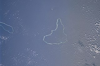
Lae Atoll is a coral atoll of 20 islands in the Pacific Ocean, and forms a legislative district of the Ralik Chain of the Marshall Islands. Its total land area is only 1.5 square kilometers (0.58 sq mi), but it encloses a lagoon with an area of 17.7 square kilometers (6.8 sq mi). It is located approximately 47 kilometers (29 mi) east of Ujae Atoll. The population of Lae Atoll was 133 in 2021. Its islands include Lae, Looj (Lotj), Bilalalon, Riblong (Ribon) and Lweijab (Lejab).

Likiep Atoll is a coral atoll of 65 islands in the Pacific Ocean, and forms a legislative district of the Ratak Chain of the Marshall Islands. It is approximately 55 kilometers (34 mi) northwest of Wotje. Its total land area is only 10.26 square kilometers (3.96 sq mi), but that encloses a deep central lagoon of 424 square kilometers (164 sq mi). Likiep Atoll also possesses the Marshall Islands' highest point, an unnamed knoll 10 meters (33 ft) above sea level. The population of Likiep Atoll was 228 in 2021.

Ujae Atoll is a coral atoll of 15 islands in the Pacific Ocean, and forms a legislative district of the Ralik Chain of the Marshall Islands. Its total land area is only 1.86 square kilometers (0.72 sq mi), but it encloses a lagoon of 185.94 square kilometers (71.79 sq mi). It is located about 122 kilometers (76 mi) west of Kwajalein Atoll.

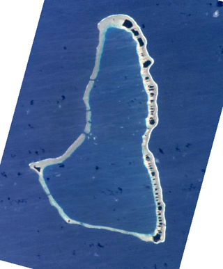
Utirik Atoll or Utrik Atoll is a coral atoll of 10 islands in the Pacific Ocean, and forms a legislative district of the Ratak Chain of the Marshall Islands. Its total land area is only 2.4 square kilometers (0.94 sq mi), but it encloses a lagoon with an area of 57.7 square kilometers (22.29 sq mi). It is located approximately 47 kilometers (29 mi) east of Ujae Atoll. The population of Utirik Atoll was 264 at the 2021 census. It is one of the northernmost Marshall Islands with permanent habitation.

Namu Atoll is a coral atoll of 54 islands in the Pacific Ocean, and forms a legislative district of the Ralik Chain of the Marshall Islands. Its total land area is only 6.27 square kilometers (2.42 sq mi), but that encloses a lagoon of 397 square kilometers (153 sq mi). It is located approximately 62 kilometers (39 mi) south-southwest of Kwajalein Atoll.

Mejit is an island in the Pacific Ocean, and forms a legislative district of the Ratak Chain of the Marshall Islands. Unlike most of the other islands of the Marshall Islands, Mejit is a stony island rather than a coral atoll, although it is surrounded by a fringing coral reef enclosing a narrow lagoon. It is located east of the main line of the Ratak chain, approximately 110 kilometers (68 mi) northeast from Wotje. The population was 230 at the 2021 census.

The Ministry of Education (MOE) is the ministry of Taiwan responsible for incorporating educational policies and managing public schools and it oversees the educational administrative agencies of local governments.

Marshall Islands High School is the main public high school located in Rita, Delap-Uliga-Djarrit, in Majuro atoll, the capital city of the Marshall Islands. Marshall Islands High School is the largest high school in the country of the Marshall Islands. MIHS is part of the Marshall Islands Public School System.

Republic of Marshall Islands Public School System (PSS) is the public school system of the Marshall Islands, headquartered in Majuro. It was established in November 2013 by Public Law 2013-23.
Jaluit High School (JHS) is a secondary school in Jabor, Jaluit Atoll, Marshall Islands. It is a part of the Marshall Islands Public School System.
Northern Islands High School (NIHS) is a secondary school in Wotje, Marshall Islands. It is a part of the Marshall Islands Public School System.
Kwajalein Atoll High School is a secondary school in Kwajalein, Marshall Islands. It is a part of the Marshall Islands Public School System.
