The Philippines is an archipelago that comprises 7,641 islands, and with a total land area of 300,000 square kilometers (115,831 sq mi), it is the world's fifth largest island country. The eleven largest islands contain 95% of the total land area. The largest of these islands is Luzon at about 105,000 square kilometers (40,541 sq mi). The next largest island is Mindanao at about 95,000 square kilometers (36,680 sq mi). The archipelago is around 800 kilometers (500 mi) from the Asian mainland and is located between Taiwan and Borneo.

Baguio, officially the City of Baguio, is a 1st class highly urbanized city in the Cordillera Administrative Region, Philippines. It is known as the "Summer Capital of the Philippines", owing to its cool climate since the city is located approximately 4,810 feet above mean sea level, often cited as 1,540 meters in the Luzon tropical pine forests ecoregion, which also makes it conducive for the growth of mossy plants, orchids and pine trees, to which it attributes its other moniker as the "City of Pines".
Benguet, officially the Province of Benguet, is a landlocked province of the Philippines located in the southern tip of the Cordillera Administrative Region in the island of Luzon. Its capital is La Trinidad.

Ifugao, officially the Province of Ifugao, is a landlocked province of the Philippines in the Cordillera Administrative Region in Luzon. Its capital is Lagawe and it borders Benguet to the west, Mountain Province to the north, Isabela to the east, and Nueva Vizcaya to the south.

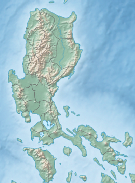
The Cordillera Administrative Region, also known as the Cordillera Region and Cordillera, is an administrative region in the Philippines, situated within the island of Luzon. It is the only landlocked region in the insular country, bordered by the Ilocos Region to the west and southwest, and by the Cagayan Valley Region to the north, east, and southeast. It is the least populous region in the Philippines, with a population less than that of the city of Manila.

Tuba, officially the Municipality of Tuba,, is a 1st class municipality in the province of Benguet, Philippines. According to the 2020 census, it has a population of 48,312 people.

The Philippine Atmospheric, Geophysical and Astronomical Services Administration is the National Meteorological and Hydrological Services (NMHS) agency of the Philippines mandated to provide protection against natural calamities and to ensure the safety, well-being and economic security of all the people, and for the promotion of national progress by undertaking scientific and technological services in meteorology, hydrology, climatology, astronomy and other geophysical sciences. Created on December 8, 1972, by reorganizing the Weather Bureau, PAGASA now serves as one of the Scientific and Technological Services Institutes of the Department of Science and Technology.
The Philippines is a typhoon-prone country, with approximately 20 typhoons entering its area of responsibility per year. Locally known generally as bagyo, typhoons regularly form in the Philippine Sea and less regularly, in the South China Sea, with the months of June to September being the most active, August being the month with the most activity. Each year, at least ten typhoons are expected to hit the island nation, with five expected to be destructive and powerful. In 2013, Time declared the country as the "most exposed country in the world to tropical storms".

Loakan Airport serves the general area of Baguio, Philippines. It is classified as a Class 2 principal airport by the Civil Aviation Authority of the Philippines (CAAP). Loakan Airport, the city's only airport, was built in 1934. Its short runway, frequent low visibility, and deep ravines at both ends of the runway continue to challenge pilots greatly, especially when it comes to landing.

John Hay Air Station, more commonly known as Camp John Hay, was a military installation in Baguio, Philippines.

The 1990 Luzon earthquake occurred on July 16 at 4:26 p.m. (PDT) or 3:26 p.m. (PST) on the densely populated island of Luzon in the Philippines. The shock had a surface wave magnitude of 7.8 and produced a 125 km-long ground rupture that stretched from Dingalan, Aurora to Kayapa, Nueva Vizcaya. The event was a result of strike-slip movements along the Philippine Fault and the Digdig Fault within the Philippine Fault System. The earthquake's epicenter was near the town of Rizal, Nueva Ecija, northeast of Cabanatuan. An estimated 1,621 people were killed, most of the fatalities located in Central Luzon and the Cordillera region.
The legislative districts of Baguio are the representations of the highly urbanized city of Baguio in the various national legislatures of the Philippines. The city is currently represented in the lower house of the Congress of the Philippines through its lone congressional district.
The legislative districts of Benguet are the representations of the province of Benguet in the various national legislatures of the Philippines. The province is currently represented in the lower house of the Congress of the Philippines through its lone congressional district.
The legislative districts of Mountain Province are the representations of Mountain Province in the various national legislatures of the Philippines. The province is currently represented in the lower house of the Congress of the Philippines through its lone congressional district.

The University of the Philippines Los Baños College of Forestry and Natural Resources is one of the 11 degree-granting units of the University of the Philippines Los Baños (UPLB). It started as the Forest School under the UP College of Agriculture in 1910, making it the oldest forestry school in the Philippines. It is one of the five founding units of UPLB upon its establishment in 1972.

The Philippine Institute of Volcanology and Seismology is a Philippine national institution dedicated to provide information on the activities of volcanoes, earthquakes, and tsunamis, as well as other specialized information and services primarily for the protection of life and property and in support of economic, productivity, and sustainable development. It is one of the service agencies of the Department of Science and Technology.

The first secondary school in Baguio, Philippines was the normal school in 1916 later called Baguio Trade School. Classes were held where Home Sweet Home now stands as this area and the present University of the Philippines Baguio location was included in the reserved land for the Bureau of Education by Forbes. In 1919 it became Mountain Province High School. Classes were held at Teacher’s Camp and native girls from all over the province were housed at Bua Dormitory known today as Pacdal Elementary School. Among the pioneer teachers were Juan Balagot, Servillano Tumaneng, Pedro Balagot, Genoveva Llamas, Esperanza Ver, Donato Guerzon, Julia Guerzon, Grace H. Miller, Petra Ramirez, and Pilar Tan and Jess L. Gains who was also the principal.

The Philippines has five types of climates: tropical rainforest, tropical monsoon, tropical savanna, humid subtropical and oceanic. The country overall is characterized by relatively high temperature, oppressive humidity and plenty of rainfall. There are two seasons in the country: the wet season and the dry season, based upon the amount of rainfall. This is also dependent on location in the country as some areas experience rain all throughout the year. The warm months of the year are March through October; the winter monsoon brings cooler air from November to February. May is the warmest month, and January, the coolest.

Metro Baguio, also known as BLISTT, is an agglomeration of the city of Baguio and five municipalities of the Philippine province of Benguet, namely: La Trinidad, Itogon, Sablan, Tuba, and Tublay.

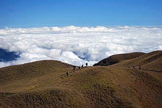
Mount Data is a mountain located in the Cordillera Central mountain range rising to a height of 2,310 metres (7,580 ft) in the north of Luzon Island, Philippines. It is about 100 kilometres (62 mi) north of Baguio on the borders of the provinces of Benguet and Mountain Province along the Halsema Highway. The mountain and surrounding area has been declared a national park since 1936. In 1940 the park was expanded to 5,513 hectares. The slopes of the mountain are covered with pine forests and mossy oak forests.