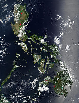
The Philippines is an archipelago that comprises 7,641 islands, and with a total land area of 300,000 square kilometers (115,831 sq mi), it is the world's fifth largest island country. The eleven largest islands contain 95% of the total land area. The largest of these islands is Luzon at about 105,000 square kilometers (40,541 sq mi). The next largest island is Mindanao at about 95,000 square kilometers (36,680 sq mi). The archipelago is around 800 kilometers (500 mi) from the Asian mainland and is located between Taiwan and Borneo.

Aparri, officially the Municipality of Aparri, is a municipality in the province of Cagayan, Philippines. According to the 2020 census, it has a population of 68,839 people.

The Babuyan Islands, also known as the Babuyan Group of Islands, is an archipelago in the Philippines, located in the Luzon Strait north of the main island of Luzon and south of Taiwan via Bashi Channel to Luzon Strait. The archipelago consists of five major islands and their surrounding smaller islands. These main islands are, counterclockwise starting from northeast, Babuyan, Calayan, Dalupiri, Fuga, and Camiguin. The Babuyan Islands are separated from Luzon by the Babuyan Channel, and from the province of Batanes to the north by the Balintang Channel.

Batanes, officially the Province of Batanes, is an archipelagic province in the Philippines, administratively part of the Cagayan Valley region. It is the northernmost province in the Philippines, and the smallest, both in population and land area. The capital is Basco, located on the island of Batan and also the most populous in the province.

Cagayan, officially the Province of Cagayan, is a province in the Philippines located in the Cagayan Valley region, covering the northeastern tip of Luzon. Its capital is Tuguegarao, the largest city of that province as well as the regional center of Cagayan Valley. It is about 431 kilometres (268 mi) northwest of Manila, and includes the Babuyan Islands to the north. The province borders Ilocos Norte and Apayao to the west, and Kalinga and Isabela to the south.

Calayan, officially the Municipality of Calayan, is a municipality in the province of Cagayan, Philippines. According to the 2020 census, it has a population of 17,410 people.

Calayan Island is located about 24 miles west-southwest of Babuyan Island off the north coast of the Philippines and belongs to the Babuyan Islands group in the Luzon Strait. The island is hemmed between Aparri and Batanes islands and it is larger than the Fuga Island, which is 25 miles (40 km) away. Calayan is home to the Calayan rail, a flightless bird identified as a separate species in 2004 and endemic to Calayan Island. The island is part of the Municipality of Calayan.

Itbayat, officially the Municipality of Itbayat,, is a municipality in the province of Batanes, Philippines. In the 2020 census, it had a population of 3,128 people.

Gonzaga, officially the Municipality of Gonzaga, is a municipality in the province of Cagayan, Philippines. According to the 2020 census, it had a population of 41,680.

San Antonio, officially the Municipality of San Antonio, is a municipality in the province of Northern Samar, Philippines. According to the 2020 census, it has a population of 8,882 people.

San Jose, officially the Municipality of San Jose, is a municipality in the province of Northern Samar, Philippines. According to the 2020 census, it has a population of 17,641 people.

Fuga Island is an island and barangay located north of Luzon and is part of the Babuyan Islands, which is the second-northernmost island group of the Philippines. Barangay Fuga Island is one of the 42 barangays under the jurisdiction of the municipality of Aparri in the province of Cagayan.

The brown-eared bulbul is a medium-sized bulbul native to eastern Asia. It is extremely common within the northern parts of its range and can be found from southern Karafuto to the northern Philippines.

The Philippine crocodile, also known as the Mindoro crocodile, the Philippine freshwater crocodile, the bukarot in Ilocano, and more generally as a buwaya in most Filipino lowland cultures, is one of two species of crocodiles found in the Philippines; the other is the larger saltwater crocodile (Crocodylus porosus). The Philippine crocodile, the species endemic only to the country, went from data deficient to critically endangered in 2008 from exploitation and unsustainable fishing methods, such as dynamite fishing. Conservation methods are being taken by the Dutch/Filipino Mabuwaya foundation, the Crocodile Conservation Society and the Zoological Institute of HerpaWorld in Mindoro island. It is strictly prohibited to kill a crocodile in the country, and it is punishable by law.

Babuyan Claro Volcano, also known as Mount Pangasun, is an active volcano located on Babuyan Island, the northernmost of the Babuyan group of islands in Luzon Strait, north of the main island of Luzon in the Philippines. It is classified as one of the active volcanoes of the country with the last confirmed eruption in 1860.
Camiguin de Babuyanes or Mount Camiguin, is an active stratovolcano on Camiguin Island which is part of the Babuyan Islands group that is located in Luzon Strait in the Philippines, north of the island of Luzon located in the municipality of Calayan in the province of Cagayan. The volcano and the island are within the jurisdiction of the municipality of Calayan, in the province of Cagayan. The island has a population of 5,231 people in 2020. There has been only one single eruption by the volcano prior to 1857.

Smith Volcano, also known as Mount Babuyan, is a cinder cone on Babuyan Island, the northernmost of the Babuyan group of islands on Luzon Strait, north of the main island of Luzon in the Philippines. The mountain is one of the active volcanoes in the Philippines, which last erupted in 1924.

The wildlife of the Philippines includes a significant number of endemic plant and animal species. The country's surrounding waters reportedly have the highest level of marine biodiversity in the world. The Philippines is one of the seventeen megadiverse countries and is a global biodiversity hotspot. In 2013, 700 of the country's 52,177 species were listed as threatened.

Babuyan Island is the highest and northernmost island in the Babuyan Islands in Luzon Strait north of Luzon Island in the Philippines and also directly south of Taiwan via Bashi Channel to Luzon Strait. The whole island makes up the barangay of Babuyan Claro, that constitute the municipality of Calayan in Cagayan province. The volcanic island has a population of 1,910 as of the 2020 census, up from 1,423 in 2010.
Barit is a small, wooded, privately owned island in northern Cagayan, Philippines. It is under the jurisdiction of Barangay Fuga Island in the municipality of Aparri.


