Related Research Articles

Mountain Province is a landlocked province of the Philippines in the Cordillera Administrative Region in Luzon. Its capital is Bontoc. Mountain Province was formerly referred to as Mountain in some foreign references. The name is usually shortened by locals to Mt. Province.

Kalinga is a landlocked province in the Philippines situated within the Cordillera Administrative Region in Luzon. Its capital is Tabuk and borders Mountain Province to the south, Abra to the west, Isabela to the east, Cagayan to the northeast, and Apayao to the north. Kalinga and Apayao are the result of the 1995 partitioning of the former province of Kalinga-Apayao which was seen to better service the respective needs of the various indigenous peoples in the area.

Kalinga-Apayao was a province of the Philippines in the Cordillera Administrative Region in the island of Luzon. It was formed, along with Benguet, Ifugao, and the new Mountain Province, from the earlier Mountain Province, with the passage of Republic Act No. 4695 in 1966. The said law was amended by RA No. 7878 in 1995, which divided the province into two new ones, Kalinga and Apayao.

The Cordillera Administrative Region, also known as the Cordillera Region, or simply, Cordillera, is an administrative region in the Philippines, situated within the island of Luzon. It is the only landlocked region in the insular country, bordered by the Ilocos Region to the west and southwest, and by the Cagayan Valley Region to the north, east, and southeast. It is the least populous region in the Philippines, with a population less than that of the city of Manila.

The Cordillera Central or Cordillera Range is a massive mountain range 320 km long north-south and 118 km east-west. The Cordillera mountain range is situated in the north-central part of the island of Luzon, in the Philippines. The mountain range encompasses all provinces of the Cordillera Administrative Region, as well as portions of eastern Ilocos Norte, eastern Ilocos Sur, eastern La Union, northeastern Pangasinan, western Nueva Vizcaya, and western Cagayan.

The indigenous peoples of the Cordillera Mountain Range of northern Luzon, Philippines are often referred to using the exonym Igorot people, or more recently, as the Cordilleran peoples. There are nine main ethnolinguistic groups whose domains are in the Cordillera Mountain Range, altogether numbering about 1.5 million people in the early 21st century.

Tanudan, officially the Municipality of Tanudan is a 4th class municipality in the province of Kalinga, Philippines. According to the 2020 census, it has a population of 8,746 people.

Kalinga is a dialect continuum of Kalinga Province in the Philippines, spoken by the Kalinga people, alongside Ilocano. The Banao Itneg variety is not one of the neighboring Itneg languages.
The legislative districts of Apayao are the representations of the province of Apayao in the various national legislatures of the Philippines. The province is currently represented in the lower house of the Congress of the Philippines through its lone congressional district.
The legislative districts of Kalinga are the representations of the province of Kalinga in the various national legislatures of the Philippines. The province is currently represented in the lower house of the Congress of the Philippines through its lone congressional district.
The legislative district of Kalinga-Apayao was the representation of the historical province of Kalinga-Apayao in the various national legislatures of the Philippines. Since 1998, the province has been represented in the lower house of the Congress of the Philippines through the separate lone congressional districts of Apayao and Kalinga.
The legislative districts of Mountain Province are the representations of Mountain Province in the various national legislatures of the Philippines. The province is currently represented in the lower house of the Congress of the Philippines through its lone congressional district.

The Kalinga people are an indigenous ethnic group whose ancestral domain is in the Cordillera Mountain Range of the northern Philippines. They are mainly found in Kalinga province which has an area of 3,282.58 sq. km. Some of them, however, already migrated to Mountain Province, Apayao, Cagayan, and Abra. The Kalinga numbered 163,167 as of 2010.

Mount Binuluan is a remote volcano in the Kalinga province of the Cordillera Administrative Region of the Philippines. The 2,329-metre-high (7,641 ft) mountain is part of the Cordillera Central mountain range on Luzon island, the largest island in the country. Binuluan exhibits active volcanism through numerous fumarole fields, solfataras and hot springs on its slope. There were reports of possible eruptions in 1952 and 1986, but they are unverified.
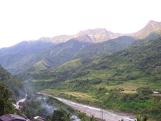
Sleeping Beauty Mountain is a mountain ridge in Kalinga province of the Philippines. The mountain is called as such because the silhouette of the northern ridge resembles a sleeping woman. It is usually best viewed from the west near the municipality Tinglayan in the Chico River valley, but it can also be viewed from the east near Tanudan.
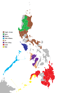
The Philippines consist of numerous upland and lowland indigenous ethnolinguistic groups living in the country, with Austronesians making up the overwhelming majority, while full or partial Negritos scattered throughout the archipelago. The highland Austronesians and Negrito have co-existed with their lowland Austronesian kin and neighbor groups for thousands of years in the Philippine archipelago. The primary difference is that they were not absorbed by centuries of Spanish and United States colonization of the Philippines, and in the process have retained their customs and traditions. This is mainly due to the rugged inaccessibility of the mountains and established headhunting and warrior cultures, which discouraged Spanish and American colonizers from coming into contact with the highlanders.

The Chico River, is a river system in the Philippines in the island of Luzon, encompassing the regions of Cordillera and Cagayan Valley. It is the longest tributary of Cagayan River with a total length of 233 km (145 mi).

Balbalasang–Balbalan National Park is a protected area of the Philippines located in the municipality of Balbalan, Kalinga in the Cordillera Administrative Region. The park covers an area of 1,338 hectares and is centered on Mount Balbalasang in the barangay of the same name near the provincial border with Abra. Dubbed the "green heart of the Cordillera", the park is representative of the rich biodiversity and landscape of this mountain region with some of the most intact pine forests and richly endemic flora and fauna. It was declared a national park in 1972 by virtue of Republic Act No. 6463.
The Mount Data Peace Accord is a peace deal signed between the government of the Philippines and the Cordillera People's Liberation Army on September 13, 1986, ending hostilities due to the latter's campaign for greater autonomy for the Cordillera region.
References
- ↑ Sulit-Braganza, Maria Chona. Earth Science' 2005 Ed. Rex Bookstore. ISBN 9789712339387 . Retrieved 31 August 2015.
| | This article about a location in the Cordillera Administrative Region is a stub. You can help Wikipedia by expanding it. |