A volcano is a rupture in the crust of a planetary-mass object, such as Earth, that allows hot lava, volcanic ash, and gases to escape from a magma chamber below the surface.

The Poás Volcano,, is an active 2,708-metre (8,885 ft) stratovolcano in central Costa Rica and is located within Poas Volcano National Park. It has erupted 40 times since 1828, including April 2017 when visitors and residents were evacuated. The volcano and surrounding park were closed for nearly 17 months, with a 2.5 kilometer safety perimeter established around the erupting crater. As of September 1, 2018 the park has reopened with limited access only to the crater observation area and requires a reservation to be made on the National Park Website. Adjacent trails to Lake Botos as well as the museum at the visitor center remained closed.

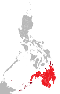
Batan Island is the main island of Batanes, an archipelagic province in the Philippines. It is the second largest of the Batanes Islands, the northernmost group of islands in the country. Four of the six municipalities of Batanes are located on the 20-kilometer (12 mi) long island including the provincial capital of Basco. The other municipalities are Ivana, Mahatao and Uyugan.

Agutaya, officially the Municipality of Agutaya, is a 5th class municipality in the province of Palawan, Philippines. According to the 2015 census, it has a population of 12,545 people.

Sierra Grande is an extinct shield volcano in northeastern New Mexico that rises 2,200 feet above the surrounding plain. It is part of the inactive Raton-Clayton volcanic field.
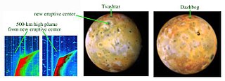
Dazhbog Patera is a volcanic feature on Jupiter's moon Io. Named after Dažbog, it has a diameter of 118.36 km. and is located 55.1°N 301.48°W. This volcano is difficult to differentiate from the other volcanoes and geological features in some images of Io. In images from the Voyager spacecraft, this caldera is quite prominent with its dark reddish floor with a darkish halo around the caldera. However, in Galileo images it is hard to tell where the volcano is. One would suspect that this would mean that it was inactive. But in July 1998, the Hubble Space Telescope using its NICMOS instrument detected a hotspot at Dazhbog.

Latukan volcano is a potentially active stratovolcano in the centre of a chain of young E-W-trending stratovolcanoes in northwest Mindanao, southeast of Lake Lanao, province of Lanao del Sur, island of Mindanao, in the Bangsamoro Autonomous Region in Muslim Mindanao.

Mount Amorong a potentially active volcano, part of the Amorong Volcanic Group, is located at the northern end of the Luzon Central Plain, in Pangasinan province, Region I, on the island of Luzon, in the Philippines.

Mount Santo Tomas is a stratovolcano in the Philippines located in the municipality of Tuba in the province of Benguet.

The Pocdol Mountains, also known as the Bacon-Manito Volcanic Group are a volcanic group of stratovolcanoes in the Philippines.

Mount Masaraga is an extinct stratovolcano located in Ligao City in the province of Albay, in the Bicol region, on Luzon Island, in the Philippines.

Mahagnao Volcano also known as part of is a dormant volcano located in the Barangay Mahagnao part of the municipality of Burauen province of Leyte, Philippines. It is also bounded by the municipalities of La Paz and MacArthur. The area is mostly composed of wetland forests and also the birth of many rivers and streams flowing on many part of Burauen and on its neighboring towns.

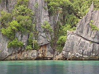
Laguna Caldera is located southeast of Manila. It has a summit elevation of 743m or 2,438 feet. The caldera, whose lake surface is only 1m above sea level, may have formed at least two major eruptions of about 1 million and 27,000-29,000 years ago.
Mount Baya is a dormant volcano in the municipality of Ganassi in Lanao del Sur province, Philippines. The mountain has a peak elevation of 1,484 meters (4,869 ft) rising from a plateau of about 950 meters (3,120 ft). It is located about 4 kilometers (2.5 mi) east of Lake Dapao and about 4.5 kilometers (2.8 mi) southwest of Lake Lanao. Between Lake Dapao and Mount Baya is Mount Gadungan, another inactive volcano.

Ozza Mons is a inactive volcano on planet Venus near the equator.