Lake Mashū is an endorheic crater lake formed in the caldera of a potentially active volcano. It is located in Akan Mashu National Park on the island of Hokkaido, Japan. It has been called the clearest lake in the world.

Mount Haruna is a dormant stratovolcano in Gunma Prefecture, in the Kantō region of eastern Honshū, Japan.

Mount Aso or Aso Volcano is the largest active volcano in Japan and among the largest in the world. Common use relates often only to the somma volcano in the centre of Aso Caldera. It stands in Aso Kujū National Park in Kumamoto Prefecture, on the island of Kyushu. Its tallest peak, Takadake, is 1,592 meters (5,223 ft) above sea level. Mount Aso is in a fairly large caldera with a circumference of around 120 km (75 mi), although sources vary on the exact distance. It is one of the 100 Famous Japanese Mountains.

Lake Towada is the largest crater lake in Honshū island, Japan. Located on the border between Aomori and Akita prefectures, it lies 400 meters (1,800 ft) above sea level and is 327 m (1,073 ft) deep, drained by the Oirase River. With a surface area of 61.1 km2 (23.6 sq mi), Towada is Japan's 12th largest lake; its bright blue color is due to its great depth. The lake is roughly circular, with two peninsulas extending from its southern shore approximately one-third into the center of the lake. The lake is a popular tourist destination.

An active volcano is a volcano that has erupted during the Holocene, is currently erupting, or has the potential to erupt in the future. A volcano that is not currently erupting but could erupt in the future is known as a dormant volcano. Volcanoes that will not erupt again are known as extinct volcanoes.
The Hakkōda Mountains are an active volcanic complex in south-central Aomori Prefecture, Japan, in Towada-Hachimantai National Park. Often called Mount Hakkōda or simply Hakkōda (八甲田), the mountains are collectively listed as one of the 100 Famous Japanese Mountains. Its highest peak, Mount Ōdake, lies 21.3 kilometers (13.2 mi) southeast of central Aomori and 28 kilometers (17 mi) west of central Towada and has an elevation of 1,585 meters (5,200 ft). The Hakkōda Mountains are a part Ōu Mountains which make up part of the Northeastern Japan Arc, a segment of the Pacific Ring of Fire. The volcanic complex consists of fourteen stratovolcanoes and lava domes arranged into two volcanic groups. The Northern Hakkōda Volcanic Group emerges from the rim of an 8-kilometer-wide (5.0 mi) caldera that dates back to the Pleistocene. The Southern Hakkōda Volcanic Group predates the caldera.

Mount Tate, also known as Tateyama, is a mountain located in the southeastern area of Toyama Prefecture, Japan. It is one of the tallest mountains in the Hida Mountains at 3,015 m (9,892 ft) and one of Japan's Three Holy Mountains along with Mount Fuji and Mount Haku. Tateyama consists of three peaks: Ōnanjiyama, Oyama, and Fuji-no-Oritate, which form a ridge line. Tateyama is the tallest mountain in the Tateyama Mountain Range.

Mount Longonot is a stratovolcano located southeast of Lake Naivasha in the Great Rift Valley of Kenya, Africa. It is thought to have last erupted in the 1860s. Its name is derived from the Maasai word Oloonong'ot, meaning "mountains of many spurs" or "steep ridges".

Mount Chōkai is an active volcano located on the border of Akita and Yamagata in the Tōhoku region of Japan, and is 2,236 m (7,336 ft) tall. Because of its (roughly) symmetrical shape and massive size, it is also variously known as Dewa Fuji (出羽富士), Akita Fuji (秋田富士) or Shōnai Fuji (庄内富士) depending on the location of the viewer. In addition to being one of the 100 Famous Landscapes of Japan, it is also included as one of the 100 famous mountains in Japan, and famous 100 Geographical Features of Japan. It is surrounded by Chōkai Quasi-National Park. It is also a National Historic Site of Japan, and is regarded as a sacred mountain by followers of the Shugendō branch of Shinto which has the shrine Chōkaisan Ōmonoimi Shrine there and is popular with hikers.

Hachimantai is a city located in Iwate Prefecture, Japan. As of 1 April 2020, the city had an estimated population of 25,076, and a population density of 29 persons per km2 in 10,531 households. The total area of the city is 862.30 square kilometres (332.94 sq mi).

Kaimondake, or Mount Kaimon, is an undissected volcano – consisting of a basal stratovolcano and a small complex central lava dome – which rises to a height of 924 metres above sea level near the city of Ibusuki in southern Kyūshū, Japan. The last eruption occurred in the year 885 CE. Because of its conic shape, Mt. Kaimon is sometimes referred to as "the Fuji of Satsuma". It is one of the 100 Famous Japanese Mountains.
Mount Myōkō is an active stratovolcano in Honshu, Japan. It is situated at the southwest of Myōkō city, Niigata Prefecture, and a part of Jōshin'etsu-kōgen National Park. Mount Myōkō is listed as one of 100 Famous Japanese Mountains, and together with Mount Yahiko, it is well known as the "famous mountain" of Niigata Prefecture.

Mount Iwaki is a stratovolcano located in western Aomori Prefecture, Tohoku, Japan. It is also referred to as Tsugaru Fuji (津軽富士) and less frequently, Okufuji (奥富士) due to its similar shape to Mount Fuji. With a summit elevation of 1,625 meters (5,331 ft) and a prominence of 1,362 meters (4,469 ft) it is the highest mountain in Aomori Prefecture.

Tequila Volcano, or Volcán de Tequila is a stratovolcano located near Tequila, Jalisco, in Mexico. It stands at a height of 2,920 meters above sea level. Stratovolcanoes, also referred to as composite volcanoes, are the "iconically" conical-shaped volcanoes, found most commonly along subduction zones. Stratovolcanoes are composed of steeply dipping layers of lava, hardened ash, and other material that erupted from the main vent such as tephra and pumice. Commonly higher than 2500 meters above sea-level, Stratovolcanoes have gentle lower slopes which gradually become steeper the higher you get with a relatively small summit crater. Due to their eruptions, Stratovolcanoes have several distinct variations giving some a specific feature such as calderas and amphitheaters.

Akan Volcanic Complex is a volcanic group of volcanoes that grew out of the Akan caldera. It is located within Akan National Park, about 50 km Northwest of Kushiro in eastern Hokkaidō, Japan.

Mount Oakan is a stratovolcano located in Akan National Park in Hokkaidō, Japan.

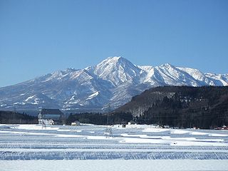
Mount Hachimantai is the highest peak of a group of stratovolcanos distributed around the Hachimantai plateau in the Ōu Mountains in northern Honshū, Japan. This volcanic plateau is part of the Nasu Volcanic Zone and straddles the border between the Iwate Prefecture and Akita Prefecture. The volcano is listed as one of the 100 Famous Japanese Mountains, and forms part of the Towada-Hachimantai National Park.

Akita-Komagatake is an active stratovolcano located 10 km east of Tazawa Lake, near the border between Akita and Iwate prefectures on Honshu Island. The volcano last erupted from 18 September 1970 to 25 January 1971. It is the highest mountain in Akita Prefecture and the second highest in Towada-Hachimantai National Park.

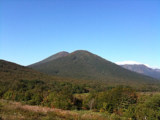
Mount Kurikoma, also known as Kurikomayama and Sukawadake is an active stratovolcano in Japan that stands 1,627 m (5,338 ft) tall. The volcano is located in Iwate Prefecture on Honshu. In addition to recent eruptions, the volcano is seismically active. It is the main feature of Kurikoma Quasi-National Park and a tourist attraction due to its hot springs, hiking trails and flora.