Pinus pumila is a native of northeastern Asia, including the islands of Japan. It shares the common name creeping pine with several other plants.

Kunashir Island, possibly meaning Black Island or Grass Island in Ainu, is the southernmost island of the Kuril Islands, an archipelago under Russian control, among which Kunashir Island and another three islands are claimed by Japan.
Hidaka Mountains is a mountain range in southeastern Hokkaido, Japan. It runs 150 km from Mount Sahoro or Karikachi Pass in central Hokkaidō south, running into the sea at Cape Erimo. It consists of folded mountains that range from 1,500 to 2,000 metres in height. Mount Poroshiri is the highest at 2,053 m. The Hidaka Mountains separate the subprefectures of Hidaka and Tokachi. Most of the range lies in the Hidaka-sanmyaku Erimo Quasi-National Park. Since the mountain range lies so far north, the alpine climate zone lies at a lower altitude.

Minami Alps National Park is a national park in the Akaishi Mountains, Chūbu region, Honshū, Japan.
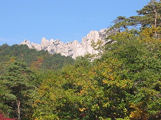
Seoraksan National Park is a national park in South Korea. It listed by the South Korean government with UNESCO as a tentative World Heritage site. The government designated the area as a nature reserve in 1965 and UNESCO designated it as a biosphere reserve in 1982. It was also the first Korean national park to be named under the National Park Law in 1970. Located on the east-central Korean peninsula, the reserve includes Injegun, Yanyanggun, and Sokchosi. It is popular with tourists and nature enthusiasts. It is home to many rare taxa of flora and fauna.

Mount Kita is a mountain of the Akaishi Mountains−"Southern Alps", in Yamanashi Prefecture, Japan.

Mount Aino, or Ainodake, is a peak of the Akaishi Mountains−Southern Alps, in Minami Alps National Park, Japan.
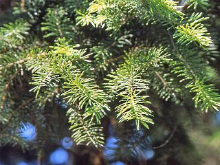
Picea maximowiczii, the Japanese bush spruce, is a species of conifer in the pine family. It is endemic to Japan; its range is limited to Akaishi Mountains, Okuchichibu Mountains and the Yatsugatake Mountains on Honshu.

Mount Kisokoma is a mountain located in Miyada, Kamiina District, and Kiso and Agematsu, Kiso District, Nagano Prefecture, in the Chūbu region of Japan. It is 2,956 m (9,698 ft) tall and is the tallest peak in the Kiso Mountains. It is also included on the list of "100 Famous Japanese Mountains." Sometimes its name is just shortened to Kisokoma. Alternative kanji for the name are 木曾駒ヶ岳 (Kisokoma-ga-take).

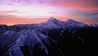
Mount Senjō is a 3,032.6-metre-high (9,949.5 ft) mountain on the border of Minami-Alps, Yamanashi, and Ina, Nagano, in Japan. This mountain is one of the major peaks of the Akaishi Mountains, and is one of the most popular peaks in the range. This mountain is also one of the 100 Famous Japanese Mountains.

Mount Iō is a mountain on the border of Chino and Minamimaki, Nagano Prefecture, Japan. This mountain is one of the major mountains of Yatsugatake Mountains. Mount Iō literally means, sulphur mountain.
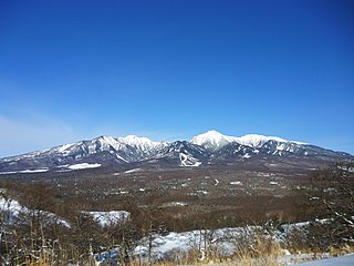
The Yatsugatake Mountains are a volcanic mountain range on the border between Nagano Prefecture and Yamanashi Prefecture on the island of Honshū in Japan.

Mount Akaishi, is a peak in the Akaishi Mountains, on the border of Shizuoka and Nagano Prefectures in central Honshū, Japan.

Mount Iō also Mount Iwo is a volcano in the Akan Volcanic Complex of Hokkaidō, Japan. It sits within the borders of the town of Teshikaga.
Mount Hijiri is a mountain located in the Akaishi Mountains in both Aoi-ku, Shizuoka, Shizuoka Prefecture and Iida, Nagano Prefecture, in the Chūbu region of Japan. It is 3,013 m (9,885 ft) tall and part of the Akaishi Mountains. It is the mountain in Minami Alps National Park located in the south most. It is also included on the list of "100 Famous Japanese Mountains." There are several mountain climbing trails and Mountain hut around the mountain. There is the Hijiri-Daira hut in the Mountain pass in the south.

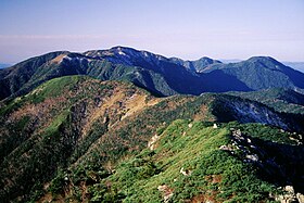
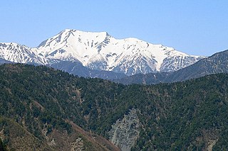
Mt. Bessan is located on the border of Gujō, Gifu Prefecture, and Hakusan, Ishikawa Prefecture, Japan, and rises to a height of 2,399 m (7,871 ft). There are two triangulation stations at the top of the mountain. Mount Haku can be seen from the north. Bessan Shrine is a short distance from the peak. This area is part of Hakusan National Park.(Note: there is a second Mt. Bessan in located in Toyama Prefecture.)

Mount Hōō is located in the western portion of Yamanashi Prefecture, Japan. Because the mountain has three peaks, it is also called Hōō Sanzan (鳳凰三山). It is in Minami Alps National Park and is one of the 100 Famous Japanese Mountains.

Mount Hiuchi is one of the 100 Famous Japanese Mountains, reaching the height of 2,462 m (8,077 ft). It is situated in Japan's Kubiki Mountains in Niigata Prefecture. It was specified for Jōshin'etsu Kōgen National Park on July 10, 1956, but since has been absorbed by the Togakushi-Renzan National Park, which encompasses Mount Myōkō and Mount Yake (焼山Yake-yama).