| Kaimondake | |
|---|---|
| 開聞岳 | |
 | |
| Highest point | |
| Elevation | 924 m (3,031 ft) |
| Coordinates | 31°10′48″N130°31′42″E / 31.18000°N 130.52833°E Coordinates: 31°10′48″N130°31′42″E / 31.18000°N 130.52833°E |
| Geography | |
| Geology | |
| Mountain type | stratovolcano |
| Last eruption | 885 [1] |

Kaimondake(開聞岳Kaimondake, Kaimon-dake), or Mount Kaimon, is an undissected volcano – consisting of a basal stratovolcano and a small central volcano, part of the Ibusuki field – which rises to a height of 924 metres above sea level near the city of Ibusuki in southern Kyūshū, Japan. The last eruption occurred in the year 885. Kaimondake is sometimes referred to as "the Fuji of Satsuma".

A volcano is a rupture in the crust of a planetary-mass object, such as Earth, that allows hot lava, volcanic ash, and gases to escape from a magma chamber below the surface.

Ibusuki is a city located in Kagoshima Prefecture, Japan, founded on April 1, 1954.

Japan is an island country in East Asia. Located in the Pacific Ocean, it lies off the eastern coast of the Asian continent and stretches from the Sea of Okhotsk in the north to the East China Sea and the Philippine Sea in the south.
Contents
 An aerial photograph of Kaimondake
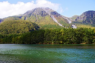
 Lake Ikeda (centre left) and Mount Kaimon (right)
 As seen from a JR Ibusuki Makurazaki Line train


Lake Ikeda is a caldera lake located 40 km south of Kagoshima city; Kyūshū island, Japan. It is perhaps best known to tourists as the location of the purported sightings of a monster named Issie, and as the largest lake on Kyūshū island with a surface area of 11 km² and a shoreline length of 15 km.

The Ibusuki Makurazaki Line is a railway line in Kagoshima Prefecture, Japan, operated by the Kyushu Railway Company. It connects Kagoshima-Chūō Station in Kagoshima, to Makurazaki Station in Makurazaki, paralleling the eastern and southern coasts of Satsuma Peninsula. Excluding the Okinawa Urban Monorail in Okinawa, this is the southernmost JR railway line in Japan, with Nishi-Ōyama Station being the southernmost station overall.
| Wikimedia Commons has media related to Mount Kaimon . |