
The White Nile is a river in Africa, the minor of the two main tributaries of the Nile, the larger being the Blue Nile. The name "White" comes from the clay sediment carried in the water that changes the water to a pale color.

The Kakwa people are a Nilotic ethnic group and part of the Karo people found in north-western Uganda, south-western South Sudan, and north-eastern Democratic Republic of the Congo, particularly to the west of the White Nile river.

Equatoria is the southernmost region of South Sudan, along the upper reaches of the White Nile and the border between South Sudan and Uganda. Juba, the national capital and the largest city in South Sudan, is located in Equatoria. Originally a province of Anglo-Egyptian Sudan, it also contained most of northern parts of present-day Uganda, including Lake Albert and West Nile. It was an idealistic effort to create a model state in the interior of Africa that never consisted of more than a handful of adventurers and soldiers in isolated outposts.
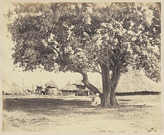
Gondokoro island is located in Central Equatoria. The island was a trading-station on the east bank of the White Nile in Southern Sudan, 1,200 kilometres (750 mi) south of Khartoum. Its importance lay in the fact that it was within a few kilometres of the limit of navigability of the Nile from Khartoum upstream. From this point the journey south to Uganda was continued overland.

Below is a list of the 18 states of the Sudan. Prior to 9 July 2011, the Republic of the Sudan was composed of 25 states. The ten southern states now form part of the independent country of South Sudan. Two additional states were created in 2012 within the Darfur region, and one in 2013 in Kordofan, bringing the total to 18.
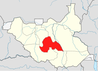
Lakes State is a state in South Sudan. It has an area of 43,595.08 km2. Rumbek is the capital of the state. Lakes is in the Bahr el Ghazal region of South Sudan, in addition to Northern Bahr el Ghazal, Western Bahr el Ghazal, and Warrap states. Bahr el Ghazal itself was a former province which was split from the Anglo-Egyptian mudiriyat, or province of Equatoria in 1948. The eastern border was the White Nile with Jonglei State on the opposite bank. To the northeast lied the Unity State. Other borders included Warrap State towards the northwest, Western Equatoria to the south and west, and Central Equatoria to the south.

Central Equatoria is a state in South Sudan. With an area of 43,033 square kilometres (16,615 sq mi), it is the smallest of the original South Sudanese states. Its previous name was Bahr al-Jabal, named after a tributary of the White Nile that flows through the state. It was renamed Central Equatoria in the first Interim Legislative Assembly on 1 April 2005 under the government of Southern Sudan. Central Equatoria seceded from Sudan as part of the Republic of South Sudan on 9 July 2011. The state's capital, Juba, is also the national capital of South Sudan. On October 2, 2015, the state was split into three states: Jubek, Terekeka, and Yei River. The state of Central Equatoria was re-established by a peace agreement signed on 22 February 2020.

Juba is the capital and largest city of South Sudan. The city is situated on the White Nile and also serves as the capital of the Central Equatoria State. It is the most recently declared national capital and had a population of 525,953 in 2017. It has an area of 52 km2 (20 sq mi), with the metropolitan area covering 336 km2 (130 sq mi).
Mount Kinyeti is the highest peak in South Sudan. It is located in the Imatong Mountains in Ikwoto County of Eastern Equatoria, near the Ugandan border. Kinyeti has an elevation of 3,187 metres (10,456 ft) above sea level. The group of high mountains that contain Kinyeti, extending to the border with Uganda, are sometimes called the Lomariti or Lolobai mountains.

The coat of arms of the Republic of South Sudan was adopted in July 2011 following independence from the Republic of Sudan. Prior to independence, South Sudan was an autonomous region of Sudan.

The flag of South Sudan was adopted following the signing of the Comprehensive Peace Agreement that ended the Second Sudanese Civil War. A different version of the flag was previously used as the flag of the Sudan People's Liberation Movement. The flag of South Sudan predates the country, as the flag was adopted in 2005, while the country became independent in 2011.

The States of South Sudan were created out of the three historic former provinces of Bahr el Ghazal (northwest), Equatoria (southern), and Greater Upper Nile (northeast). The states are further divided into 79 counties.

Southern Sudan was an autonomous region consisting of the ten southern states of Sudan between its formation in July 2005 and independence as the Republic of South Sudan in July 2011. The autonomous government was initially established in Rumbek and later moved to Juba. It was bordered by Ethiopia to the east; Kenya, Uganda, and the Democratic Republic of the Congo to the south; and the Central African Republic to the west. To the north lies the predominantly Arab and Muslim region directly under the control of the central government. The region's autonomous status was a condition of a peace agreement between the Sudan People's Liberation Army/Movement (SPLA/M) and the Government of Sudan represented by the National Congress Party ending the Second Sudanese Civil War. The conflict was Africa's longest running civil war.
South Sudan, officially the Republic of South Sudan, is a landlocked country in eastern Central Africa. It is bordered by Ethiopia, Sudan, the Central African Republic, the Democratic Republic of the Congo, Uganda, and Kenya, and includes the vast swamp region of the Sudd, formed by the White Nile and known locally as the Bahr al Jabal, meaning "Mountain Sea". The population was 11,088,796 in 2023, and Juba is the capital and largest city. South Sudan gained independence from Sudan on 9 July 2011, making it the most recent sovereign state or country with widespread recognition as of 2024.

The geography of South Sudan describes the physical features of South Sudan, a country in East Africa. South Sudan is a landlocked country and borders – clockwise – Sudan from the north, Ethiopia from the east, Kenya, Uganda and the Democratic Republic of the Congo from the south and the Central African Republic from the west.

South Sudan became the world's newest country and Africa's 55th nation on 9 July 2011. The South Sudanese Civil War, which started in December 2013, undermined economic development achieved since independence, making humanitarian work difficult to conduct within the country. As such, South Sudan is facing economic stagnation and instability in its first 10 years after independence. Moreover, poverty is widespread throughout the country as a result of inter-communal conflict, displacement, and external fear.
The Bandingilo National Park, sometimes spelled Badingilo, is a national park located in South Sudan's Equatoria region. The park covered the erstwhile states of Central Equatoria and Eastern Equatoria. It was established in 1992. Situated in a wooded area near the White Nile river, it is over 10,000 square kilometres (3,900 sq mi) in size. It also contains large marshlands stretching up into Jonglei state.
Energy in Sudan describes energy and electricity production, consumption and imports in Sudan. The chief sources of energy in 2010 were wood and charcoal, hydroelectric power, and oil. Sudan is a net energy exporter. Primary energy use in Sudan was 179 TWh and 4 TWh per million persons in 2008.

South Sudan is one of the African countries known as an important oil producer, whereas, South Sudan also has mineral resources like copper, gold, diamonds, limestone among others. Government is promoting investment particularly in exploration and also developing the mining projects in South Sudan.

