Sohag

Last updated • 9 min readFrom Wikipedia, The Free Encyclopedia
Sohag
سوهاج
Sohag Multi.jpg
Montage of Sohag's sights
Nickname: 
Bride of the Nile
Egypt adm location map.svg
Red pog.svg
Sohag
Location in Egypt
Coordinates: 26°33′N31°42′E / 26.550°N 31.700°E / 26.550; 31.700
Country Egypt
Governorate Sohag
Markaz Sohag Markaz
Government
  GovernorDr/Tarik al-Faki
Area
[1]
  Land9.03 km2 (3.49 sq mi)
Elevation
[1]
67 m (220 ft)
Population
 (2021) [1]
   City
266,944
  Rank21st in Egypt
  Density29,500/km2 (76,500/sq mi)
   Metro
600,000
Demonym(s) Sohagi, Sohagy
Time zone UTC+2 (EET)
Postal code
82749 [2]
Area code+20 (Egypt) 93 (City) [3]
Website www.sohag.gov.eg (in Arabic)

Sohag (Arabic : سوهاج, romanized: Sawhāj, Egyptian Arabic pronunciation: [soˈhæːɡ] , Sa'idi Arabic pronunciation: [suːˈhaːdʒ] ), also spelled as Suhag or Suhaj, [4] is a city on the west bank of the Nile in Egypt. It has been the capital of Sohag Governorate since 1960, before which the capital was Girga and the name of the governorate was Girga Governorate. It also included Esna Governorate (nowadays Qena Governorate). [5]

Contents

History

The modern city developed from the village of Suhay (Arabic : السوهاى) (or Sumay), the name of which eventually transformed into Suhaj, [6] and is located on the site of several ancient settlements, the largest of which is Bompae (Ancient Greek : Βομπαη; Coptic : ⲃⲟⲙⲡⲁϩⲟ, lit. 'channel of Paho' or Coptic : ⲡⲓⲃⲟⲙⲡⲁϩⲉ, lit. 'the place of Paha'). [7] [8] The others include Tmupaie (Ancient Greek : Τμουπαει, Coptic : ⲧⲙⲟⲩⲡⲁϩⲟ, lit. 'the island of Paha'), Bay (Arabic : الباى, possibly an Arabisation of the aforementioned "Paha") and Sawaqi (Arabic : سواقى).

Geography

Satellite image of Sohag Sohag by NASA.jpg
Satellite image of Sohag

Sohag lies on a fertile agricultural plain on the western bank of the Nile, [9] approximately 6 kilometres (3.7 miles) southwest of Akhmim. The city includes two islands; Karaman-ez-Zahur Island is larger and uninhabited, and ez-Zahur Island (جزيرة الزهور, Ǧazīrat az-Zuhur, "Flower Island") has some homes.

Economy

The city Sohag itself encloses only a few archaeological sites, hence tourism represents only a small portion of the city's income. Other sources of income include trade, small industries of carpets, furniture, spinning and weaving and sugar. Administrative and educational services are two big sectors of income.

Demographics

19281976198619962006201220182021
20,760 [10] 101,758132,965170,125189,695201,339248,174266,944
Starting in 1928: Population of Sohag City [11]

Religion

Islam and Christianity are the main religions in Sohag; about 75% of the population are Muslim.[ citation needed ].

Historical sites

Mosques

South side of the Sidi Arif Mosque SohagArifSouthSide.jpg
South side of the Sidi Arif Mosque
Inside the Sidi Arif Mosque SohagArifInside.jpg
Inside the Sidi Arif Mosque
Mihrab and minbar of the Sidi Arif Mosque SohagArifMihrab.jpg
Mihrab and minbar of the Sidi Arif Mosque
Ceiling of the Sidi Arif Mosque SohagArifDome.jpg
Ceiling of the Sidi Arif Mosque

In the masonry on the eastern, southern and western sides are stones engraved with historical inscriptions moved from previous buildings, including a decree of the penultimate Mamluk sultan al-Ghawri (1441–1516) from the year 1506 (911 AH) on the southeastern side.

South side of the el-Farshuti Mosque SohagFarschutiSouthSide.jpg
South side of the el-Farshuti Mosque
Inside the el-Farshuti Mosque SohagFarschutiInside.jpg
Inside the el-Farshuti Mosque
Mihrab and minbar of the el-Farshuti Mosque SohagFarschutiMihrab.jpg
Mihrab and minbar of the el-Farshuti Mosque
Ceiling of the el-Farshuti Mosque SohagFarschutiDome.jpg
Ceiling of the el-Farshuti Mosque

Churches

Sohag has two important churches that were erected in the 20th century: the Church of the Holy Virgin and the Church of Saint George.

Church of the Holy Virgin SohagVirginToWest.jpg
Church of the Holy Virgin
Inside the Church of the Holy Virgin SohagVirginInside.jpg
Inside the Church of the Holy Virgin
Icon of the Holy Virgin with her child SohagVirginIcon.jpg
Icon of the Holy Virgin with her child

Monasteries

White Monastery

The Coptic White Monastery is a Coptic Orthodox monastery named after Saint Shenouda the Archimandrite. It is located about 5 kilometres (3.1 miles) west of Sohag. The monastery's name is derived from the color of the white limestone in its outside walls. The surviving building is the church of what was once a much larger monastery complex. [12]

Red Monastery

The Red Monastery is a Coptic Orthodox monastery named after an Egyptian saint called Pishay. It is located about 5 kilometres (3.1 miles) north of the White Monastery. The monastery's name is derived from the color of the construction material of its outside walls, consisting of red (burnt) brick. The walls are considerably thicker at the base than at the top and, like the walls of Ancient Egyptian temples, they are surmounted by cavetto moldings. The Red Monastery is architecturally similar to the White Monastery. [12]

Red Monastery RedMonasteryOutside.jpg
Red Monastery
White Monastery WhiteMonasterySouthSide.jpg
White Monastery

Temples and cemeteries

Sohag is the site of a temple built for the goddess Repyt (Triphis) by Ptolemy XV Caesarion and subsequent Roman emperors. South of this temple was an earlier temple of Ptolemy IX Soter II (see also Athribis Project). One of the nearby tombs of the brothers Ibpemeny "the younger" and Pemehyt of the late second century BC, has two zodiacs on its ceiling. [13]

Subdivisions

Sohag is informally divided into the East District (Arabic: حى شرق) and the West District (Arabic: حي غرب). Among the most notable regions of the West District are:

The East District is considered a more upscale district; it includes some of the most affluent neighborhoods of the city including 15th Street, Al Kashef Street, Jumhuriya Street, The Courts Compound, and The Technical and Agricultural Schools. Some of the most notable locales of the East District include:

Climate

The Köppen-Geiger climate classification system classifies Sohag's climate as hot desert (BWh). Luxor, Minya, Sohag, Qena and Asyut have the widest difference of temperatures between days and nights of any city in Egypt, with almost 16 °C (29 °F) difference. Sohag is one of the warmest places in Egypt due to its location on the eastern side of Sahara in North Africa. Sohag is ranked the 5th driest place in Egypt and the 9th globally. Also ranked 4th warmest place in Egypt and 296th globally.

Climate data for Sohag
MonthJanFebMarAprMayJunJulAugSepOctNovDecYear
Record high °C (°F)30.8
(87.4)
37.5
(99.5)
42.2
(108.0)
43.9
(111.0)
47.4
(117.3)
47.9
(118.2)
47.0
(116.6)
43.4
(110.1)
44.4
(111.9)
43.1
(109.6)
37.0
(98.6)
33.3
(91.9)
47.9
(118.2)
Mean daily maximum °C (°F)22.0
(71.6)
23.8
(74.8)
27.5
(81.5)
33.6
(92.5)
37.7
(99.9)
39.6
(103.3)
38.8
(101.8)
37.8
(100.0)
36.0
(96.8)
33.7
(92.7)
28.2
(82.8)
23.5
(74.3)
31.9
(89.4)
Daily mean °C (°F)13.9
(57.0)
15.6
(60.1)
18.9
(66.0)
24.5
(76.1)
29.1
(84.4)
30.7
(87.3)
31.0
(87.8)
29.9
(85.8)
27.9
(82.2)
25.1
(77.2)
19.8
(67.6)
15.4
(59.7)
23.5
(74.3)
Mean daily minimum °C (°F)7.3
(45.1)
8.8
(47.8)
11.8
(53.2)
16.6
(61.9)
21.1
(70.0)
23.1
(73.6)
24.1
(75.4)
23.1
(73.6)
20.6
(69.1)
17.8
(64.0)
13.0
(55.4)
9.2
(48.6)
16.4
(61.5)
Record low °C (°F)0.4
(32.7)
2.6
(36.7)
3.3
(37.9)
7.7
(45.9)
11.5
(52.7)
15.7
(60.3)
17.6
(63.7)
18.0
(64.4)
15.9
(60.6)
11.4
(52.5)
4.8
(40.6)
2.6
(36.7)
0.4
(32.7)
Average precipitation mm (inches)0
(0)
1
(0.0)
0
(0)
0
(0)
0
(0)
0
(0)
0
(0)
0
(0)
0
(0)
0
(0)
0
(0)
0
(0)
1
(0)
Average precipitation days0.10.10.20.100000000.20.7
Average relative humidity (%)57504436303137434544515643.7
Source 1: NOAA [14]
Source 2: Climate Charts [15]

Culture

Language

A version of the dialect continuum of Saidi Arabic is spoken by the people of Sohag. Most urbanized people, however, may speak to varying degrees Egyptian Arabic. [16]

Museums

The Sohag Museum contains about 5,000 artifacts gathered from around the Sohag governorate, including items stretching from the Middle Kingdom to Greco-Roman times. [9] [17]

Bazaars

Souq el-Qisareya: The bazaar in Sohag is named suq Qaiṣarīya and is partly covered.

Souq el-Itnein is a weekly market held every Monday morning; vegetables, fruits, animals and traditional hand made objects (like baskets, farming axes and bags) are sold there. The weekly market is believed to have originated during the Ancient Egyptian era. The souq is now in the south of the city and is held in the streets and beside the city cemetery. [9]

Transport

Southern Highway Sohag south bridge.jpg
Southern Highway

Sohag is linked to Giza and northern cities by the road of Asyut Western Desert, Eastern Desert Road and Rural Road, which also connects it to the railways. [18]

In February 2010, a highway linking Sohag to the Red Sea city Hurghada was opened to ease movement between Upper Egypt and the Red Sea coastal region.[ citation needed ] In May 2010, the Egyptian President Hosni Mubarak inaugurated Sohag International Airport. [19]

CityDistance (km)
Alexandria 692
Port Said 691
Ismaïlia 616
Suez 605
Cairo 471
Aswan 428
Luxor 205
Asyut 98

Education

Sohag Military school is one of the oldest schools in Sa'id/Upper Egypt, established 1928 Sohag military school.jpg
Sohag Military school is one of the oldest schools in Sa'id/Upper Egypt, established 1928

Educational establishments in Sohag include: Primary schools:

Middle schools:

High schools:

University

Sohag University is a public university with more than 40,000 students [20] located on the eastern side of the city. It was established under the banner of South Valley University but became independent in 2006. There are currently ten colleges in Sohag University.

Sports

Sohag Stadium Sohag stadium.jpg
Sohag Stadium

The most popular sport in Sohag is Association football.[ citation needed ] Sohag has many football clubs, including the Egyptian Premier League (EPL) team Sohag FC. In addition, EPL club has El Gouna FC used Sohag stadium as a home ground at times. [21]

Notable people

Notable people who originate from or live in Sohag include:

Nearby attractions

Osireion, Abydos Osireion.jpg
Osireion, Abydos

See also

Related Research Articles

<span class="mw-page-title-main">Aswan</span> City in Egypt

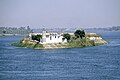
Aswan is a city in Southern Egypt, and is the capital of the Aswan Governorate.

<span class="mw-page-title-main">Nag Hammadi</span> City in Qena, Egypt

Nag Hammadi is a city and markaz in Upper Egypt. It is located on the west bank of the Nile in the Qena Governorate, about 80 kilometres (50 mi) north-west of Luxor. The city had a population of close to 61,737 as of 2023.

<span class="mw-page-title-main">Luxor</span> City in southern Egypt

Luxor is a city in Upper Egypt, which includes the site of the Ancient Egyptian city of Thebes. Luxor had a population of 1,333,309 in 2020, with an area of approximately 417 km2 (161 sq mi) and is the capital of the Luxor Governorate. It is among the oldest inhabited cities in the world.

<span class="mw-page-title-main">Sohag Governorate</span> Governorate of Egypt

Sohag Governorate is one of the governorates of Egypt. It is located in the southern part of the country, and covers a stretch of the Nile Valley. Since 1960, its capital has been the city of Sohag. Prior to that, the capital was the city of Girga and the name of the governorate was Girga Governorate.

<span class="mw-page-title-main">Akhmim</span> City in Sohag, Egypt

Akhmim is a city in the Sohag Governorate of Upper Egypt. Referred to by the ancient Greeks as Khemmis or Chemmis and Panopolis, it is located on the east bank of the Nile, 6 kilometres (4 mi) to the northeast of Sohag.

<span class="mw-page-title-main">Esna</span> City in Luxor, Egypt

Esna is a city of Egypt. It is located on the west bank of the Nile some 55 km (34 mi) south of Luxor. The city was formerly part of the modern Qena Governorate, but as of 9 December 2009, it was incorporated into the new Luxor Governorate.

<span class="mw-page-title-main">El Hawawish</span> Ancient necropolis in Egypt

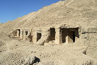
El Hawawish is the ancient necropolis (cemetery) for the city of Akhmim in the 9th Nome of Upper Egypt (UE09), in modern the Sohag Governorate, Egypt.

El Araba El Madfuna is a town in Egypt. It is located south of Sohag.

<span class="mw-page-title-main">Girga</span> City in Sohag, Egypt

Girga, alternatively Digirga or Digurga is a city in the Sohag Governorate of Upper Egypt. It is located on the west bank of the Nile River. It is the metropolitan see of the Coptic Orthodox Church, and is the oldest continuously-inhabited city on the African continent.

Athribis, also known to the ancient Greeks as Triphieion or Tripheion, and to the ancient Egyptians as Hut-Repyt, was an ancient city of Egypt, in the Panopolite nome. The modern villages of Wannina and Nag' Hamad in the Sohag Governorate are situated nearby. It is located some 10 km (6 mi) southwest of the city of Akhmim and about 3 km (2 mi) south of the White Monastery, on the west bank of the Nile.

<span class="mw-page-title-main">Kafr El Sheikh</span> City in Egypt

Kafr El Sheikh is an Egyptian city and the capital of Kafr El Sheikh Governorate, Egypt, about 134 km north of Cairo, in the Nile Delta of lower Egypt. As of November 2006, the town had a population of around 500,000.

<span class="mw-page-title-main">El Balyana</span> Place in Sohag, Egypt

El Balyana is a small town in the Sohag Governorate of Upper Egypt. Located on the west bank of the Nile, it is situated near the ancient Egyptian city of Abydos.

<span class="mw-page-title-main">Minya Governorate</span> Governorate of Egypt

Minya Governorate is one of the governorates of Upper Egypt. Its capital city, Minya, is located on the left bank of the Nile River.

El Salamuni is a village in the Upper Egyptian Sohag Governorate. It is located northeast of the city of Akhmim.

<span class="mw-page-title-main">Tahta</span> City in Sohag, Egypt

Tahta is a city in the Sohag Governorate of Upper Egypt. It is located on the west bank of the Nile in an area known for its agricultural richness. Tahta had a population of 85,528 in the 2017 census. Egyptologists believe that the modern name may derive from the word Ta-ho-ty. Two famous monasteries are located near Tahta, the White Monastery and the Red Monastery. The town has a small but significant Coptic Catholic community. Its most famous resident was the reformist intellectual Rifa'a al-Tahtawi, who was born in Tahta in 1801, and who wrote and translated many books following his trip to Paris in 1826 as the imam and chaplain for the first group of Egyptians whom Mehmet Ali Pasha sent to study in western Europe.

<span class="mw-page-title-main">Coptic architecture</span> Architecture of the Copts

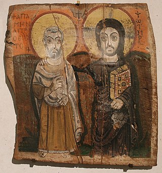
Coptic architecture is the architecture of the Coptic Christians, who form the majority of Christians in Egypt.

<span class="mw-page-title-main">Church of Saint Menas (Cairo)</span> One of the oldest Coptic churches in Egypt

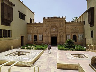
The Coptic Orthodox Church of Saint Menas is a Coptic Orthodox church near Coptic Cairo and is one of the oldest Coptic churches in Egypt, dating back to the sixth century.

Saqultah is a small Upper Egyptian city near Akhmim. It is located on the east bank of the Nile, in the Sohag Governorate.

<span class="mw-page-title-main">Dar El Salam</span> City in Egypt

Dar el-Salam is a small Upper Egyptian city near Akhmim. It is located on the east bank of the Nile, in the Sohag Governorate.

Metropolitan Wissa is the serving Metropolitan Bishop of the Coptic Orthodox Diocese of El Balyana, in Sohag Governorate, Egypt. His Diocese encompasses the districts of El Balyana (Abydos), Bardis (district), Awlad Toukh and the villages under their jurisdictions.

References

  1. 1 2 3 "Egypt: Governorates, Major Cities & Towns - Population Statistics, Maps, Charts, Weather and Web Information". www.citypopulation.de. Retrieved 17 June 2023.
  2. "Egypt Postal Code". Egypt-cairo.com. Retrieved 15 October 2017.
  3. Prozzone. "Sohag, EGYPT :: city code, std code, dial code, country code, long distance". www.prozzone.com. Retrieved 15 October 2017.
  4. "World Gazetteer: Sohag - profile of geographical entity including nam…". 16 December 2012. Retrieved 15 October 2017.[ dead link ]
  5. Law, Gwillim (1999). Administrative Subdivisions of Countries: A Comprehensive World Reference, 1900 through 1998 (snippet view). Jefferson, NC: McFarland. p. 114. ISBN   978-0-7864-0729-3 . Retrieved 2010-08-07.
  6. محمد رمزي. القاموس الجغرافي للبلاد المصرية. p. 128.
  7. "TM Places". www.trismegistos.org. Retrieved 2019-09-01.
  8. "TM Places". www.trismegistos.org. Retrieved 2022-08-09.
  9. 1 2 3 Richardson, Dan (2003). The Rough Guide to Egypt. Rough Guides. pp. 322–323. ISBN   1-84353-050-3.
  10. Baedeker, Karl; Steindorff, Georg: Ägypten und der Sûdan: Handbuch für Reisende, Leipzig: Baedeker, 1928, 8. ed., p. 221.
  11. "World Gazetteer: Sohag". Archived from the original on 16 December 2012.
  12. 1 2 Haag, Michael (2004). Egypt. New Holland Publishers. pp. 222–226. ISBN   1-86011-163-7.
  13. Richard Talbert, Barrington Atlas of the Greek and Roman World , ( ISBN   0-691-03169-X), p. 77.
  14. "Sohag Climate Normals 1961–1990". National Oceanic and Atmospheric Administration . Retrieved January 17, 2016.
  15. "Sohag, Egypt: Climate, Global Warming, and Daylight Charts and Data". Climate Charts. Retrieved 9 July 2013.
  16. Miller, Catherine (2005-09-19). "Between accomodation [sic] and resistance: Upper Egyptian migrants in Cairo". Linguistics. 43 (5): 903–956. doi:10.1515/ling.2005.43.5.903. ISSN   1613-396X. S2CID   145655182.
  17. "The Sohag Museum". Supreme Council of Antiquities - Museums. Retrieved December 14, 2016.
  18. Vivian, Cassandra (2008-01-01). "Western Desert of The Egypt". The Western Desert of Egypt.
  19. "Hosni Mubarak | Biography, History, & Facts | Britannica". www.britannica.com. Retrieved 2022-05-25.
  20. "جامعة سوهاج". Sohag-univ.edu.eg. Retrieved 15 October 2017.
  21. "El Gouna FC - Misr El Makkasa Live - Summary: Football Scores & Highlights - 17/05/2022". Eurosport. Retrieved 2022-05-25.
  22. 1 2 "Abydos | ancient city, Egypt | Britannica". www.britannica.com. Retrieved 2022-05-25.