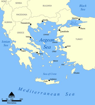
The Aegean Sea is an elongated embayment of the Mediterranean Sea between Europe and Asia. It is located between the Balkans and Anatolia, and covers an area of some 215,000 km2 (83,000 sq mi). In the north, the Aegean is connected to the Marmara Sea, which in turn connects to the Black Sea, by the straits of the Dardanelles and the Bosphorus, respectively. The Aegean Islands are located within the sea and some bound it on its southern periphery, including Crete and Rhodes. The sea reaches a maximum depth of 3,544 m (11,627 ft) to the east of Crete. The Thracian Sea and the Sea of Crete are main subdivisions of the Aegean Sea.

Aswan is a city in Southern Egypt, and is the capital of the Aswan Governorate.

Alexandria is the second largest city in Egypt and the largest city on the Mediterranean coast. It lies at the western edge of the Nile River delta. Founded in c. 331 BC by Alexander the Great, Alexandria grew rapidly and became a major centre of Hellenic civilisation, eventually replacing Memphis, in present-day Greater Cairo, as Egypt's capital. Called the "Bride of the Mediterranean" internationally, Alexandria is a popular tourist destination and an important industrial centre due to its natural gas and oil pipelines from Suez.

Eilat is Israel's southernmost city, with a population of 53,151, a busy port and popular resort at the northern tip of the Red Sea, on what is known in Israel as the Gulf of Eilat and in Jordan as the Gulf of Aqaba. The city is considered a tourist destination for domestic and international tourists heading to Israel.

Sharm El Sheikh, alternatively rendered Sharm el-Sheikh, Sharm el Sheikh, or Sharm El-Sheikh, is an Egyptian city on the southern tip of the Sinai Peninsula, in South Sinai Governorate, on the coastal strip along the Red Sea. Its population is approximately 13,000 as of 2023. Sharm El Sheikh is the administrative hub of Egypt's South Sinai Governorate, which includes the smaller coastal towns of Dahab and Nuweiba as well as the mountainous interior, St. Catherine and Mount Sinai. It was historically a fishing town and military base, and was developed into a commercial and tourist-centric city in 1968 by Israel. Today, the city and holiday resort is a significant centre for tourism in Egypt, while also attracting many international conferences and diplomatic meetings.
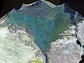
The Nile Delta is the delta formed in Lower Egypt where the Nile River spreads out and drains into the Mediterranean Sea. It is one of the world's larger deltas—from Alexandria in the west to Port Said in the east; it covers 240 km (150 mi) of the Mediterranean coastline and is a rich agricultural region. From north to south the delta is approximately 160 km (100 mi) in length. The Delta begins slightly down-river from Cairo.

Hurghada is a coastal city that serves as the largest city and capital of the Red Sea Governorate of Egypt. Hurghada has grown from a small fishing village to one of the largest resort destinations along the Red Sea coast, stretching close to 40 km.

Sousse or Soussa is a city in Tunisia, capital of the Sousse Governorate. Located 140 km (87 mi) south of the capital Tunis, the city has 271,428 inhabitants (2014). Sousse is in the central-east of the country, on the Gulf of Hammamet, which is a part of the Mediterranean Sea. Its economy is based on transport equipment, processed food, olive oil, textiles, and tourism. It is home to the Université de Sousse.

Amorgos is the easternmost island of the Cyclades island group and the nearest island to the neighboring Dodecanese island group in Greece. Along with 16 neighboring islets, the largest of which is Nikouria Island, it comprises the municipality of Amorgos, which has a land area of 126.346 square kilometres and at the 2021 census had a population of 1,961.

The Kharga Oasislit. 'the outer'; Coptic: (ϯ)ⲟⲩⲁϩ ⲛ̀ϩⲏⲃ(di)wah enhib, "Oasis of Hib", (ϯ)ⲟⲩⲁϩ ⲙ̀ⲯⲟⲓ(di)wah empsoi "Oasis of Psoi") is the southernmost of Egypt's five western oases. It is located in the Western Desert, about 200 km to the west of the Nile valley. "Kharga" or "El Kharga" is also the name of a major town located in the oasis, the capital of New Valley Governorate. The oasis, which was known as the 'Southern Oasis' to the Ancient Egyptians, the 'outer' to the Greeks and Oasis Magna to the Romans, is the largest of the oases in the Libyan desert of Egypt. It is in a depression about 160 km long and from 20 km to 80 km wide. Its population is 67,700 (2012).

Marsa Alam is a tourist town in south-eastern Egypt, located on the western shore of the Red Sea. It is currently seeing fast increasing popularity as a tourist destination and development following the opening of Marsa Alam International Airport in 2003. Marsa Alam is considered one of the newly established towns, as its development began in 1995 through the investments of Kuwaiti Al-Kharafi Group, which Established the town with all its facilities, resorts and infrastructure, to make Marsa Alam one of the most attractive places in Egypt for tourism. The town is located on an area of 38,433 km2, 274 km south of Hurghada, and 134 km south of Qusayr, and its 60 meters above sea level. It is inhabited by about 11,497 residents.

Qena is a city in Upper Egypt, and the capital of the Qena Governorate. Situated on the east bank of the Nile, it was known in antiquity as Kaine and Maximianopolis. Gauthier identifies Qena with ancient Shabt. Qena meaning in Arabic "very red" of fertile land.

Duba is a small city on the northern Red Sea coast, of Saudi Arabia. It is in Tabuk Province. Local citizens describe it as The Pearl of the Red Sea. The population of Duba is about 39,000.

Nuweiba is a coastal town in the eastern part of Sinai Peninsula, Egypt, located on the coast of the Gulf of Aqaba.

Finike, the ancient Phoenix or Phoinix also formerly Phineka, is a municipality and district of Antalya Province, Turkey. Its area is 768 km2, and its population is 49,720 (2022). It lies on the Mediterranean coast of Antalya Province in Turkey, to the west of the city of Antalya, along the Turkish Riviera. It is located on the southern shore of the Teke peninsula, and the coast here is a popular tourist destination. However, Finike is best known for its oranges, the symbol of the town.

The Northern Coast of Egypt extends for about 1,050 km (650 mi) along the Mediterranean Sea, it covers entirely the northern territory of Egypt. It is one of the longest Mediterranean coastlines, and is popularly known of its snow-white sand beaches and crystal clear water.
Tourism is one of the leading sources of income, crucial to Egypt's economy. At its peak in 2010, the sector employed about 12% of workforce of Egypt, serving approximately 14.7 million visitors to Egypt, and providing revenues of nearly $12.5 billion as well as contributing more than 11% of GDP and 14.4% of foreign currency revenues.

Rhodes is the largest of the Dodecanese islands of Greece and is their historical capital; it is the ninth largest island in the Mediterranean Sea. Administratively, the island forms a separate municipality within the Rhodes regional unit, which is part of the South Aegean administrative region. The principal town of the island and seat of the municipality is the city of Rhodes, which had 50,636 inhabitants in 2011. In 2022, the island had a population of 125,113 people. It is located northeast of Crete and southeast of Athens. Rhodes has several nicknames, such as "Island of the Sun" due to its patron sun god Helios, "The Pearl Island", and "The Island of the Knights", named after the Knights of Saint John of Jerusalem, who ruled the island from 1310 to 1522.
Caryanda or Karyanda was a city on the coast of ancient Caria in southwestern Anatolia. Stephanus of Byzantium describes it as a city and harbour (λίμην) near Myndus and Cos. But λιμήν, in the text of Stephanus, is an emendation or alteration: the manuscripts use the word λίμνη ('lake'). Strabo places Caryanda between Myndus and Bargylia, and he describes it, according to the common text, as "a lake, and island of the same name with it;" and thus the texts of Stephanus, who derived his information from Strabo, agree with the texts of Strabo. Pliny simply mentions the island Caryanda with a town; but he is in that passage only enumerating islands. In another passage he mentions Caryanda as a place on the mainland, and Pomponius Mela does so too. Scylax of Caryanda, one of the most famous mariners and explorers of ancient times, was a native of Caryanda. He lived in the late 6th and early 5th centuries BC and served the Persian king Darius I.

Syedra was an ancient port city in region of ancient Cilicia, Pamphylia, or Isauria, on the southern coast of modern-day Turkey between the towns of Alanya and Gazipaşa. Syedra was settled in the 7th century BCE, and abandoned in the 13th century CE. The town had a port at sea level and an upper town 400m above. Ptolemy places it in Cilicia. Stephanus of Byzantium assigns it to Isauria. Hierocles places it in Pamphylia.