Desouk دسوق | |
---|---|
![]() Clockwise, from top: Desouk Bridge, Ibrahim El Desouki Mosque, City Hall, Nile in Desouk, a statue of Ramesses II with Goddess Sekhmet, Desouk War Memorial, New Desouk Bridge. | |
![]() Map of Desouk | |
Coordinates: 31°8′32″N30°38′42″E / 31.14222°N 30.64500°E | |
Country | ![]() |
Governorate | Kafr El Sheikh |
Area | |
• Total | 8.635 km2 (3.334 sq mi) |
Elevation | 0 m (0 ft) |
Population (2021) [1] | |
• Total | 149,291 |
• Density | 17,000/km2 (45,000/sq mi) |
Time zone | UTC+2 (EST) |
ZIP code | |
Area code | +2 047 |
Desouk (Arabic : دسوق, Egyptian Arabic pronunciation: [dɪˈsuːʔ] ) is a city in northern Egypt. Located 80 km east of Alexandria, in the Kafr El Sheikh Governorate and had a population of 137,660 inhabitants as of 2011. [4] It is bordered to the west by the Beheira Governorate.
Desouk dates back to at least c. 3200 BC and was part of the ancient city of Buto before the unification of Upper and Lower Egypt. From 1250 to 1517, the city of Desouk was part of the Gharbia province. From 1798 to 1801, it was part of the now-defunct Rosetta province.
The city's name could be derived from Ancient Egyptian : tꜣ-sbk, lit. 'land of Sobek ', attested on a statuette from Sais dating to the Third Intermediate Period, through Coptic : *ⲧⲉⲥⲟⲩⲭⲓ, or from Ancient Egyptian : tꜣ-ı͗ꜣ.t-sbk, attested in Greek as Thasoukhios (Ancient Greek : Θασουχιος) and Tasoukis (Ancient Greek : Τασουκις). The cult of Sobek had presence to the west of Disuq, on the other side of the Nile.
Other proposal derives it from the rare Arabic verb dasaqa "to overflow (about a basin)" and its nominal form daysaq "bassin full of water" [5] which in turn has its origin in Ancient Greek : δίσκος, lit. 'disk, salver', but it is considered implausible. Another improbable etymology is a Copto-Arabic word combining the Coptic feminine definite article ti- (Coptic : ϯ-) with Arabic : سوق, romanized: suq, lit. 'market'. [6]
Desouk is a member of the Organization of Islamic Capitals and Cities [7] due to the location of important Islamic shrines in the city, such as the tomb of Egyptian Sufi Saint Ibrahim El Desouki, which is located in the main mosque in the center of Desouk.
Desouk lies on the Nile, on the eastern banks of the Rosetta branch, where there are only two bridges entering the city.
Many important Egyptians hail from Desouk: Youssef El-Mansy, Ahmed Zewail, [8] Mohammed Roshdy, Evelyn Ashamallah, and Abdel-Salam Mohammed Nasar, a politician in the city.
Köppen-Geiger climate classification system classifies its climate as hot desert (BWh), the same as the rest of Egypt.
Climate data for Desouk | |||||||||||||
---|---|---|---|---|---|---|---|---|---|---|---|---|---|
Month | Jan | Feb | Mar | Apr | May | Jun | Jul | Aug | Sep | Oct | Nov | Dec | Year |
Mean daily maximum °C (°F) | 17.8 (64.0) | 18.8 (65.8) | 21.5 (70.7) | 25.3 (77.5) | 29.2 (84.6) | 30.9 (87.6) | 32.2 (90.0) | 32.3 (90.1) | 30.6 (87.1) | 28.8 (83.8) | 24.6 (76.3) | 19.9 (67.8) | 26.0 (78.8) |
Daily mean °C (°F) | 12.4 (54.3) | 13.1 (55.6) | 15.4 (59.7) | 18.6 (65.5) | 22.3 (72.1) | 24.6 (76.3) | 26.1 (79.0) | 26.2 (79.2) | 24.7 (76.5) | 22.8 (73.0) | 19.1 (66.4) | 14.5 (58.1) | 20.0 (68.0) |
Mean daily minimum °C (°F) | 7 (45) | 7.4 (45.3) | 9.3 (48.7) | 11.9 (53.4) | 15.4 (59.7) | 18.4 (65.1) | 20.1 (68.2) | 20.2 (68.4) | 18.8 (65.8) | 16.8 (62.2) | 13.6 (56.5) | 9.1 (48.4) | 14.0 (57.2) |
Average precipitation mm (inches) | 26 (1.0) | 20 (0.8) | 9 (0.4) | 4 (0.2) | 3 (0.1) | 0 (0) | 0 (0) | 0 (0) | 0 (0) | 6 (0.2) | 13 (0.5) | 23 (0.9) | 104 (4.1) |
Source: Climate-Data.org [9] |
Desouk is renowned for the presence of Ibrahim El Desouki Mosque, which attracts over a million visitors annually on average. The mosque is the final resting place of the last Sufi pole, Imam Ibrahim El Desouki, established around the year 1277. It currently covers an area of 6400 square meters, and the Ladies' Mosque occupies 600 square meters, making it one of the largest mosques in the Islamic world in terms of area. It houses a university Islamic library as well. In Desouk, an annual celebration is held for the birth of Ibrahim El-Desouki in October, lasting a week with strict security measures. The celebration honors the memory of 77 Sufi orders from various parts of the world. [10] During this time, the city attracts more than a million visitors [11] from various provinces of Egypt and some countries worldwide, [12] making it one of the largest religious celebrations in Egypt. [13] Among the festivities, the custodian of the Ibrahim El-Desouki shrine rides a horse and is paraded through the streets of Desouk after the afternoon prayer on the final day of the celebration. [14] Additionally, an annual celebration of Ragabiya is held in late April or early May each year, lasting for a week as well. [15]
There are numerous Pharaonic artifacts in the ancient city of Buto, which served as the political capital of the Lower Egypt. Its construction dates back to the Predynastic period, and it is located northeast of Desouk, about 12 km away. [16] Buto was a significant religious center where every king or prince, upon ascending to rule, was required to go to Buto to legitimize their rule by the priests. This was done for worship and to draw closer to the goddess Wadjet, the Lady of the City, a central figure in the Egyptian myth of Isis and Osiris. [17]
The area is characterized by several artifacts, some dating back to the Predynastic period, such as the Wadjet Temple, Horus Statue, and the double statue of the goddess Sekhmet and King Ramesses II, among many other artifacts. [18] Locally, the region is known as "Tall Al-Fara'in," named after the founding pharaohs. It spans an area of 175 acres (0.7 km²). [19] [20]
Buto, Bouto, Butus or Butosus was a city that the Ancient Egyptians called Per-Wadjet. It was located 95 km east of Alexandria in the Nile Delta of Egypt. What in classical times the Greeks called Buto, stood about midway between the Taly (Bolbitine) and Thermuthiac (Sebennytic) branches of the Nile, a few kilometers north of the east-west Butic River and on the southern shore of the Butic Lake.
Rosetta or Rashid is a port city of the Nile Delta, 65 km (40 mi) east of Alexandria, in Egypt's Beheira governorate. The Rosetta Stone was discovered there in 1799.
Mansoura is a city in Egypt located on the eastern bank of the Damietta branch of the Nile river. The city is the capital of the Dakahlia Governorate and has a population of 621,953 as of 2021.
North Sinai Governorate is one of the governorates of Egypt. It is located in the north-eastern part of the country, and encompasses the northern half of the Sinai Peninsula. It is bordered in the north by the Mediterranean Sea, in the south by South Sinai Governorate, in the west by Port Said, Ismailia, and Suez Governorates, and in the east by the Gaza Strip in Palestine and Israel. Its capital is the city of El Arish. A governorate is administered by a governor, who is appointed by the President of Egypt and serves at the president's discretion.
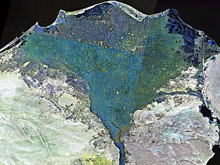
The Nile Delta is the delta formed in Lower Egypt where the Nile River spreads out and drains into the Mediterranean Sea. It is one of the world's larger deltas—from Alexandria in the west to Port Said in the east; it covers 240 km (150 mi) of the Mediterranean coastline and is a rich agricultural region. From north to south the delta is approximately 160 km (100 mi) in length. The Delta begins slightly down-river from Cairo.
6th of October is a city in the Giza Governorate of Egypt. It is a satellite city, located adjacent to Giza, and is part of the Greater Cairo region.
Kafr El Sheikh is an Egyptian city and the capital of Kafr El Sheikh Governorate, Egypt, about 134 km north of Cairo, in the Nile Delta of lower Egypt. As of November 2006, the town had a population of around 500,000.
Kafr El Sheikh Governorate is one of the governorates of Egypt. It lies in the northern part of the country, along the western branch of the Nile in the Nile Delta. Its capital is the city of Kafr El Sheikh.
Egypt is divided, for the purpose of public administration, according to a three-layer hierarchy and some districts are further subdivided, creating an occasional fourth layer. It has a centralized system of local government officially called local administration as it is a branch of the Executive.
Salfit governorate is one of the 16 Governorates of the State of Palestine. It is located in the northwestern West Bank, held under Israeli occupation, bordered by the governorates of Ramallah and al-Bireh to the south, Nablus to the east and Qalqilya in the north as well as, Israel to the west. Its district capital and largest city is Salfit. According to the Palestinian Central Bureau of Statistics (PCBS), the governorate had a population of 75,444 inhabitants in mid-year 2017. In the PCBS's census in 1997, which registered 46,671 residents, refugees accounted for 7.7% of the total population. There were 37,613 male residents and 36,143 females.
The Tariqa Burhāniyya or Desuqiyya is a Sufi order founded by Sayyidi Abul Hasan ash-Shadhuli and Sayyidi Ibrahim al Disuqi in the 13th century. The order's full name is Tariqa Burhaniya Disuqiya Shadhuliya, referring to its founders. Burhan-uddin is a surname of Sayyidi Ibrahim al Disuqi and means "evidence of religion". The order has a registered charity in the UK, Tariqa Burhaniya D'suqiyya Shazuliyya (tbds); Registered Charity Number: 1041647.
Baltim is a city in the Kafr El Sheikh Governorate, in the north coast of Egypt.
Desouk Sporting Club is an Egyptian football club based in Desouk, Kafr El Sheikh, Egypt. The team is a member of the Egyptian Third Division.
'Ibrahīm Bin ʿAbd-El-ʿAzīz 'Abu al-Magd, better known as El Desouki (الدسوقي), was an Egyptian Imam and the founder of the Desouki Order.
El Hawamdeya is a city in the Giza Governorate of Egypt.
Qallin is a city in the Kafr El Sheikh Governorate, Egypt.
Fuwwah is a city in the Kafr El Sheikh Governorate, Egypt.
The Sidi Ibrahim El Desouki Mosque, is a mosque and shrine complex in Desouk, Egypt. The name of this mosque is derived from the Sufi mystic and Ash'ari scholar Ibrahim al-Dasuqi, who is buried in the shrine of the building alongside his brother, Sharaf al-Din Musa. The mosque is also one of the oldest mosques in Egypt, being built during the Mamluk era.
Kafr Zurqan is a village in the Tala Markaz in Monufia Governorate in Egypt. It is located next to the village of Mit Abu El Kom, where former President Anwar Sadat was born. It is affiliated to the local unit in Mit Abu al-Kom.