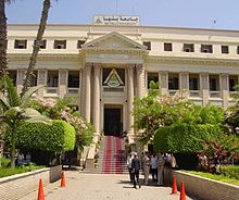
Zagazig is a city in Egypt. Situated in the eastern part of the Nile delta, it is the capital of the governorate of Sharqia.

El Mahalla El Kubra – commonly shortened to El Maḥalla – is the largest city of the Gharbia Governorate and in the Nile Delta, with a population of 535,278 as of 2012. It is a large industrial and agricultural city in Egypt, located in the middle of the Nile Delta on the western bank of the Damietta Branch tributary. The city is known for its textile industry, and hosts the Misr Spinning and Weaving Company which employs around 27,000 people.

Giza is the third-largest city in Egypt by area after Cairo and Alexandria; and fourth-largest city in Africa by population after Kinshasa, Lagos, and Cairo. It is the capital of Giza Governorate with a total population of 4,872,448 in the 2017 census. It is located on the west bank of the Nile opposite central Cairo, and is a part of the Greater Cairo metropolis. Giza lies less than 30 km (18.64 mi) north of Memphis, which was the capital city of the unified Egyptian state during the reign of pharaoh Narmer, roughly 3100 BC.

Rosetta or Rashid is a port city of the Nile Delta, 65 km (40 mi) east of Alexandria, in Egypt's Beheira governorate. The Rosetta Stone was discovered there in 1799.

Monufia Governorate is one of the governorates of Egypt. Monufia’s name was derived from the hieroglyphic word “Nafr”, which means “The Good Land”. It is located in the northern part of the country in the Nile Delta, to the south of Gharbia Governorate and to the north of Cairo. The governorate of Monufia is known for being the birthplace of four Egyptian presidents: Mohammad Anwar el-Sadat, Hosni Mubarak, Adly Mansour, and Abdel Fatah al-Sisi. The governorate is named after Menouf, an ancient city which was the capital of the governorate until 1826. The current governor is Said Mohammed Mohammed Abbas.

Qalyubia Governorate is one of the governorates of Egypt. Located in Lower Egypt. It is situated north of Cairo in the Nile Delta region. Its capital is Banha.
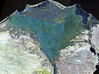
The Nile Delta is the delta formed in Lower Egypt where the Nile River spreads out and drains into the Mediterranean Sea. It is one of the world's larger deltas—from Alexandria in the west to Port Said in the east; it covers 240 km (150 mi) of the Mediterranean coastline and is a rich agricultural region. From north to south the delta is approximately 160 km (100 mi) in length. The Delta begins slightly down-river from Cairo.
Kafr El Dawwar is a major industrial city and municipality on the Nile Delta in the Beheira Governorate of northern Egypt. Located approximately 30 km from Alexandria, the municipality has a population of about 265,300 inhabitants and comprises a number of smaller towns and villages.

Akhmim is a city in the Sohag Governorate of Upper Egypt. Referred to by the ancient Greeks as Khemmis or Chemmis and Panopolis, it is located on the east bank of the Nile, 6 kilometres (4 mi) to the northeast of Sohag.
Desouk is a city in northern Egypt. Located 80 km east of Alexandria, in the Kafr El Sheikh Governorate and had a population of 137,660 inhabitants as of 2011. It is bordered to the west by the Beheira Governorate.

Samannud is a city (markaz) located in Gharbia Governorate, Egypt. Known in classical antiquity as Sebennytos, Samannud is a historic city that has been inhabited since the Ancient Egyptian period. As of 2019, the population of the markaz of Samannud was estimated to be 410,388, with 83,417 people living in urban areas and 326,971 in rural areas.

Mit Ghamr is a town in Dakahlia Governorate, Egypt. It is a major center producing aluminium accounting for more than 70% of Egypt's total production, especially aluminum utensils. It is a city in Dakahlia Governorate, where it is second only to Al Mansurah in population and importance.

Sohag, also spelled as Suhag or Suhaj, is a city on the west bank of the Nile in Egypt. It has been the capital of Sohag Governorate since 1960, before which the capital was Girga and the name of the governorate was Girga Governorate. It also included Esna Governorate.

Girga, alternatively Digirga or Digurga is a city in the Sohag Governorate of Upper Egypt. It is located on the west bank of the Nile River. It is the metropolitan see of the Coptic Orthodox Church, and is the oldest continuously-inhabited city on the African continent.
Sakha, also known by the ancient name of Xois is a town in Kafr El Sheikh Governorate of Egypt. Located near the center of the Nile Delta, it is a city of great antiquity, identified with the ancient Egyptian city of Ḫꜣsww(t).

Kafr El Sheikh is an Egyptian city and the capital of Kafr El Sheikh Governorate, Egypt, about 134 km north of Cairo, in the Nile Delta of lower Egypt. As of November 2006, the town had a population of around 500,000.

Damanhur is a city in Lower Egypt, and the capital of the Beheira Governorate. It is located 160 km (99 mi) northwest of Cairo, and 70 km (43 mi) E.S.E. of Alexandria, in the middle of the western Nile Delta. Damanhur is a historic city, which history can be dated back to the Old Kingdom of Egypt. The modern city has also absorbed the ancient villages Shubra al-Jadida, Tāmus, Askanida and Chortaso.

Fuwwah is a city in the Kafr El Sheikh Governorate, Egypt.
Minya al-Qamh is the capital of the eponymous markaz (county) in the Nile Delta governorate of Sharqia, Egypt. The markaz is home to 11 local units, 82 villages, and 245 hamlets. In 2017, the Minya al-Qamh markaz was home to 769,333 people, while city had 87,875 residents.