Baltim

Last updated • 1 min readFrom Wikipedia, The Free Encyclopedia
Baltim
blTym1.jpg
Baltim resort center
Egypt adm location map.svg
Red pog.svg
Baltim
Location in Egypt
Coordinates: 31°35′57″N31°05′30″E / 31.59917°N 31.09167°E / 31.59917; 31.09167
CountryFlag of Egypt.svg  Egypt
Governorate Kafr El Sheikh
Area
[1]
  Total13.8 sq mi (35.7 km2)
Population
 (2021) [1]
  Total51,280
  Density3,700/sq mi (1,400/km2)
Time zone UTC+2 (EST)

Baltim (Arabic : بلطيم pronounced [bɑlˈtˤiːm] ) is a city in the Kafr El Sheikh Governorate, in the north coast of Egypt.

Contents

History

The second part of the town's name preserves Ancient Egyptian : tm.t "end, furthest part (of Egypt)". [2]

Baltim was the beneficiary of a tax reduction under the reign of the sultan Barquq. Ibn Battuta noted it as the capital of the district of Burullus, a position which it held through the late 1800s. [3]

The 1885 Census of Egypt recorded Baltim as a nahiyah in the district of Aklim el-Borollos in Gharbia Governorate; at that time, the population of the city was 4,286 (2,182 men and 2,104 women). [4]

Climate

Baltim's climate is typical to the northern coastal line which is the most moderate in Egypt. It features a hot desert climate (Köppen: BWh), but prevailing winds from the Mediterranean Sea greatly moderate the temperatures, making its summers moderately hot and humid while its winters mild and moderately wet.

The hottest temperature recorded was on April 15, 1998 which was 41 °C (106 °F) and the coldest temperature was on February 8, 2006 which was 2 °C (36 °F). [5]

Port Said, El Qoseir, Baltim, Damietta and Alexandria have the least temperature variation in Egypt, additionally, Rafah, Alexandria, Abu Qir, Rosetta, Baltim, Kafr El Dawwar and Mersa Matruh are the wettest.

Climate data for Baltim
MonthJanFebMarAprMayJunJulAugSepOctNovDecYear
Record high °C (°F)27
(81)
31
(88)
36
(97)
41
(106)
38
(100)
40
(104)
39
(102)
39
(102)
39
(102)
38
(100)
34
(93)
29
(84)
41
(106)
Mean daily maximum °C (°F)17.8
(64.0)
18.3
(64.9)
20.6
(69.1)
23.2
(73.8)
26.3
(79.3)
29.3
(84.7)
30
(86)
30.7
(87.3)
29.2
(84.6)
27.5
(81.5)
24.3
(75.7)
19.6
(67.3)
24.7
(76.5)
Daily mean °C (°F)14.4
(57.9)
14.6
(58.3)
16.5
(61.7)
18.5
(65.3)
21.5
(70.7)
24.8
(76.6)
26.3
(79.3)
27
(81)
25.3
(77.5)
23.5
(74.3)
20.2
(68.4)
16
(61)
20.7
(69.3)
Mean daily minimum °C (°F)11.1
(52.0)
10.9
(51.6)
12.4
(54.3)
13.8
(56.8)
16.7
(62.1)
20.4
(68.7)
22.6
(72.7)
23.4
(74.1)
21.5
(70.7)
19.5
(67.1)
16.2
(61.2)
12.4
(54.3)
16.7
(62.1)
Record low °C (°F)3
(37)
2
(36)
4
(39)
9
(48)
9
(48)
12
(54)
19
(66)
12
(54)
13
(55)
13
(55)
10
(50)
7
(45)
2
(36)
Average precipitation mm (inches)47
(1.9)
29
(1.1)
12
(0.5)
3
(0.1)
3
(0.1)
0
(0)
0
(0)
0
(0)
1
(0.0)
9
(0.4)
21
(0.8)
49
(1.9)
174
(6.8)
Source 1: Climate-Data.org [6]
Source 2: Voodoo Skies for record temperatures [5]

Another source reports less variable temperatures and more precipitation, which would classify it as a hot steppe climate (BsH) in the Koppen climate classification system.

Climate data for Baltim
MonthJanFebMarAprMayJunJulAugSepOctNovDecYear
Record high °C (°F)24
(75)
25
(77)
30
(86)
31
(88)
36
(97)
35
(95)
35
(95)
33
(91)
33
(91)
31
(88)
28
(82)
25
(77)
36
(97)
Mean daily maximum °C (°F)18
(64)
17
(63)
18
(64)
20
(68)
23
(73)
25
(77)
27
(81)
28
(82)
28
(82)
26
(79)
22
(72)
19
(66)
23
(73)
Daily mean °C (°F)16
(61)
16
(61)
17
(63)
18
(64)
22
(72)
24
(75)
26
(79)
27
(81)
26
(79)
24
(75)
21
(70)
18
(64)
21
(70)
Mean daily minimum °C (°F)14
(57)
14
(57)
15
(59)
16
(61)
19
(66)
22
(72)
24
(75)
25
(77)
24
(75)
23
(73)
20
(68)
17
(63)
19
(67)
Record low °C (°F)5
(41)
5
(41)
8
(46)
11
(52)
15
(59)
18
(64)
21
(70)
22
(72)
21
(70)
18
(64)
15
(59)
10
(50)
5
(41)
Average precipitation mm (inches)55.8
(2.20)
39.2
(1.54)
15.5
(0.61)
6.0
(0.24)
3.1
(0.12)
0.0
(0.0)
0.0
(0.0)
0.0
(0.0)
0.0
(0.0)
15.5
(0.61)
42.0
(1.65)
58.9
(2.32)
236
(9.29)
Source: MSN [7]

See also

Related Research Articles

<span class="mw-page-title-main">El Alamein</span> City in Matrouh, Egypt

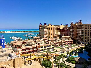
El Alamein is a town in the northern Matrouh Governorate of Egypt. Located on the Mediterranean Sea, it lies 106 kilometres (66 mi) west of Alexandria and 300 kilometres (186 mi) northwest of Cairo. The town is located on the site of the ancient city Antiphrai which was built by the Romans.(Greek: Ἀντίφραι).

<span class="mw-page-title-main">Abu Qir</span> Place in Alexandria Governorate, Egypt

Abu Qir, formerly also spelled Abukir or Aboukir, is a town on the Mediterranean coast of Egypt, near the ruins of ancient Canopus and 23 kilometers (14 mi) northeast of Alexandria by rail. It is located on Abu Qir Peninsula, with Abu Qir Bay to the east.

<span class="mw-page-title-main">Mersa Matruh</span> City in Matrouh, Egypt

Mersa Matruh, also transliterated as Marsa Matruh, is a port in Egypt and the capital of Matrouh Governorate. It is located 240 km (150 mi) west of Alexandria and 222 km (138 mi) east of Sallum on the main highway from the Nile Delta to the Libyan border. The city is also accessible from the south via another highway running through the Western Desert towards Siwa Oasis and Bahariya Oasis.

<span class="mw-page-title-main">Rosetta</span> City in Beheira governorate, Egypt

Rosetta or Rashid is a port city of the Nile Delta, 65 km (40 mi) east of Alexandria, in Egypt's Beheira governorate. The Rosetta Stone was discovered there in 1799.

<span class="mw-page-title-main">Damietta</span> City in Egypt

Damietta is a port city and the capital of the Damietta Governorate in Egypt. It is located at the Damietta branch, an eastern distributary of the Nile Delta, 15 kilometres (9.3 mi) from the Mediterranean Sea, and about 200 kilometres (120 mi) north of Cairo. It was a Catholic bishopric and is a multiple titular see. It is also a member of the UNESCO Global Network of Learning Cities.

<span class="mw-page-title-main">Nile Delta</span> Delta produced by the Nile River at its mouth in the Mediterranean Sea

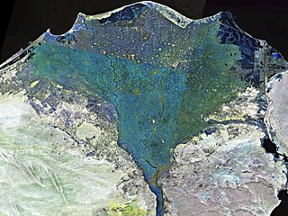
The Nile Delta is the delta formed in Lower Egypt where the Nile River spreads out and drains into the Mediterranean Sea. It is one of the world's larger deltas—from Alexandria in the west to Port Said in the east; it covers 240 km (150 mi) of the Mediterranean coastline and is a rich agricultural region. From north to south the delta is approximately 160 km (100 mi) in length. The Delta begins slightly down-river from Cairo.

<span class="mw-page-title-main">Kafr El Dawwar</span> City in Beheira, Egypt

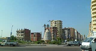
Kafr El Dawwar is a major industrial city and municipality on the Nile Delta in the Beheira Governorate of northern Egypt. Located approximately 30 km from Alexandria, the municipality has a population of about 265,300 inhabitants and comprises a number of smaller towns and villages.

<span class="mw-page-title-main">Desouk</span> Place in Kafr El Sheikh, Egypt

Desouk is a city in northern Egypt. Located 80 km east of Alexandria, in the Kafr El Sheikh Governorate and had a population of 137,660 inhabitants as of 2011. It is bordered to the west by the Beheira Governorate.

<span class="mw-page-title-main">Benha</span> City in Qalyubia, Egypt

Banha is the capital of the Qalyubiyya Governorate in north-eastern Egypt. Between the capital of Cairo and the city of Tanta, Banha is an important transport hub, as rail lines from Cairo to various cities in the Nile Delta pass through it and Benha it's a part of The Greater Cairo. Banha was founded as a city in 1850.

<span class="mw-page-title-main">Northern coast of Egypt</span> Mediterranean coast of Egypt

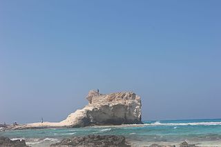
The Northern Coast of Egypt extends for about 1,050 km (650 mi) along the Mediterranean Sea, it covers entirely the northern territory of Egypt. It is one of the longest Mediterranean coastlines, and is popularly known of its snow-white sand beaches and crystal clear water.

<span class="mw-page-title-main">Kafr El Sheikh</span> City in Egypt

Kafr El Sheikh is an Egyptian city and the capital of Kafr El Sheikh Governorate, Egypt, about 134 km north of Cairo, in the Nile Delta of lower Egypt. As of November 2006, the town had a population of around 500,000.

<span class="mw-page-title-main">El Qoseir</span> City in Red Sea, Egypt

El Qoseir is a city in eastern Egypt, located on the Red Sea west coast. Populated for approximately 5,000 years, its ancient Egyptian name was Tjau, while its ancient Greek name during the Ptolemaic era was Myos Hormos. Historically, it was the endpoint of the Wadi Hammamat trail, an important route connecting Egypt and the Red Sea. El Qoseir is located 138 kilometers south of Hurghada, 130 km north of Marsa Alam and 68 km north of the Marsa Alam International Airport. In 1986, its population was approximately 20,000. Today, the population of El Qoseir is around 50,000.

Dekernes is a town in the center of the Dakahlia Governorate of Egypt. It is situated about 20 km east of Mansoura, the capital of Dakahlia.

<span class="mw-page-title-main">Agami</span> Place in Alexandria, Egypt

Agami is a city in the Alexandria Governorate of Egypt. Twenty kilometres (12 mi) west of Alexandria, the town is a popular destination for both local Alexandrians and tourists in Giza and Cairo.

Rafah is a city in North Sinai and Egypt's eastern border with the Gaza Strip. It is the capital of Rafah center in North Sinai Governorate, and is situated on the eastern Mediterranean coast of Egypt.

<span class="mw-page-title-main">Climate of Egypt</span>

Egypt essentially has a hot desert climate. The climate is generally extremely dry all over the country except on the northern Mediterranean coast which receives rainfall in winter. In addition to rarity of rain, extreme heat during summer months is also a general climate feature of Egypt although daytime temperatures are more moderated along the northern coast.

<span class="mw-page-title-main">El Mahmoudiyah</span> City in Beheira, Egypt

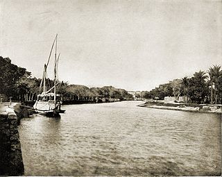
El Mahmoudia is an Egyptian city on the connection point between the Nile and Mahmoudiyah canal. It is a city with a history despite its modernity. It was one of the most important trade ports on the Nile River. Trading ships traveling from Upper Egypt and Lower Egypt to Alexandria passed through its lock and up the Mahmoudiyah Canal. Trading ships from Alexandria also carried imported merchandise to Cairo through the port.

<span class="mw-page-title-main">El Bagour</span> City in Monufia, Egypt

El Bagour is a small city in northern Egypt. It is located in the Nile Delta in the Monufia Governorate. El Bagour has 48 surrounding villages.

Sheikh Zuweid is a Bedouin town in the North Sinai Governorate of Egypt near the border with the Gaza Strip. It is situated between the cities of Arish and Rafah and is 334 kilometers northeast of Cairo. It has a population of around 60,000 as of 2015.

<span class="mw-page-title-main">Damanhur</span> City in Beheira, Egypt

Damanhur is a city in Lower Egypt, and the capital of the Beheira Governorate. It is located 160 km (99 mi) northwest of Cairo, and 70 km (43 mi) E.S.E. of Alexandria, in the middle of the western Nile Delta. Damanhur is a historic city, which history can be dated back to the Old Kingdom of Egypt. The modern city has also absorbed the ancient villages Shubra al-Jadida, Tāmus, Askanida and Chortaso.

References

  1. 1 2 "Egypt: Governorates, Major Cities & Towns - Population Statistics, Maps, Charts, Weather and Web Information". citypopulation.de. Retrieved 17 March 2023.
  2. Peust, Carsten (2010). Die Toponyme vorarabischen Ursprungs im modernen Ägypte. Göttingen. p. 21.{{cite book}}: CS1 maint: location missing publisher (link)
  3. Maspero, Jean; Wiet, Gaston (1919). Matériaux pour servir à la géographie de l'Égypte. Cairo: Institut français d'archéologie orientale. p. 47.
  4. Egypt min. of finance, census dept (1885). Recensement général de l'Égypte. p. 63. Retrieved 22 June 2020.
  5. 1 2 "Baltim, Egypt". Voodoo Skies. Retrieved 28 May 2013.
  6. "Climate: Baltim - Climate graph, Temperature graph, Climate table". Climate-Data.org. Retrieved 13 August 2013.
  7. "Baltim Historical Weather". msn.com. Retrieved 12 April 2021.