River Kafu

Last updated
Kafu
Kabi
River
Country Uganda
Source Kitoma Swamp, Kibaale District
 - location Kitoma, Western Region , Uganda
 - elevation 1,100 m (3,609 ft)
 - coordinates 01°09′00″N31°04′55″E / 1.15000°N 31.08194°E / 1.15000; 31.08194
Mouth Victoria Nile, Masindi District
 - location Masindi Port, Western Region , Uganda
 - elevation 1,040 m (3,412 ft)
 - coordinates 01°38′51″N32°05′40″E / 1.64750°N 32.09444°E / 1.64750; 32.09444 Coordinates: 01°38′51″N32°05′40″E / 1.64750°N 32.09444°E / 1.64750; 32.09444
Length 180 km (112 mi)
Rivers and lakes of Uganda.png
Rivers and lakes of Uganda, with River Kafu shown as Kabi

River Kafu is a river in Uganda, in East Africa. On some older maps, the river is labelled as River Kabi.

River Natural flowing watercourse

A river is a natural flowing watercourse, usually freshwater, flowing towards an ocean, sea, lake or another river. In some cases a river flows into the ground and becomes dry at the end of its course without reaching another body of water. Small rivers can be referred to using names such as stream, creek, brook, rivulet, and rill. There are no official definitions for the generic term river as applied to geographic features, although in some countries or communities a stream is defined by its size. Many names for small rivers are specific to geographic location; examples are "run" in some parts of the United States, "burn" in Scotland and northeast England, and "beck" in northern England. Sometimes a river is defined as being larger than a creek, but not always: the language is vague.

Uganda republic in East Africa

Uganda, officially the Republic of Uganda, is a landlocked country in East-Central Africa. It is bordered to the east by Kenya, to the north by South Sudan, to the west by the Democratic Republic of the Congo, to the south-west by Rwanda, and to the south by Tanzania. The southern part of the country includes a substantial portion of Lake Victoria, shared with Kenya and Tanzania. Uganda is in the African Great Lakes region. Uganda also lies within the Nile basin, and has a varied but generally a modified equatorial climate.

East Africa Eastern region of the African continent

East Africa or Eastern Africa is the eastern region of the African continent, variably defined by geography. In the United Nations Statistics Division scheme of geographic regions, 20 territories make up Eastern Africa:

Contents

Location

The Kafu River is located in the western part of Uganda. It starts from a swamp approximately 12 kilometres (7.5 mi), northeast of the village of Kitoma, in Kibaale District, Western Uganda. It flows eastwards at first, then it turns north, to empty into the Victoria Nile, approximately 8 kilometres (5.0 mi), upstream of the town of Masindi Port, in Masindi District, also in Western Uganda.

Kibaale District District in Uganda

Kibaale District, is a district in the Western Region of Uganda. The district headquarters are in the town of Kibaale.

Western Region, Uganda Region in Western, Uganda

The Western region is one of four regions in the country of Uganda. As of Uganda's 2014 census, the region's population was 8,874,862.

Masindi Port Place in Masindi District, Uganda

Masindi Port is a town in Uganda.

The source of River Kafu is located near Kitoma, with coordinates: Latitude:1.1500; Longitude:31.0820. [1] River Kafu enters the Victoria Nile near Masindi Port, with coordinates: Latitude:1.6475; Longitude:32.0945. [2] On its course eastwards, northeastwards and northwards, the river traverses or forms the borders of the following districts : Kibaale District, Hoima District, Kyankwanzi District, Nakaseke District, Nakasongola District and Masindi District.

Hoima District District in Uganda

Hoima District is a district in Western Uganda. Like most other Ugandan districts, it is named after its main municipal centre, Hoima.

Kyankwanzi District District

Kyankwanzi District is the northernmost district in the Central Region of Uganda and Buganda Kingdom, bordering Bunyoro. The district headquarters are in Butemba Town.

Nakaseke District District in Uganda

Nakaseke District is a district in Central Uganda. It is named after Nakaseke, the largest town in the district. However, the district headquarters are located at Butalangu.

Overview

The swamp, out of which River Kafu arises, is also transversed by another river system called River Nkusi. River Nkusi however, arises elsewhere and passes through the said swamp and flows westwards to empty into Lake Albert, along the International border between Uganda and the Democratic Republic of the Congo. At its source, River Kafu is an altitude of approximately 1,100 metres (3,600 ft). At its point of entry into River Nile, the altitude is approximately 1,040 metres (3,410 ft).

Lake Albert (Africa) lake in Uganda and the Democratic Republic of the Congo

Lake Albert, also Mwitanzige and formerly Lake Mobutu Sese Seko, is a lake located in Uganda and the Democratic Republic of the Congo. It is one of the African Great Lakes. Lake Albert is Africa's seventh-largest lake, and the world's twenty-seventh largest lake by volume.

Democratic Republic of the Congo Country in Central Africa

The Democratic Republic of the Congo, also known as DR Congo, the DRC, DROC, Congo-Kinshasa, or simply the Congo, is a country located in Central Africa. It is sometimes anachronistically referred to by its former name of Zaire, which was its official name between 1971 and 1997. It is, by area, the largest country in Sub-Saharan Africa, the second-largest in all of Africa, and the 11th-largest in the world. With a population of over 78 million, the Democratic Republic of the Congo is the most populated officially Francophone country, the fourth-most-populated country in Africa, and the 16th-most-populated country in the world.

The length of River Kafu is approximately 180 kilometres (110 mi), from source to end. [3]

See also

Related Research Articles

Masindi District District in Uganda

Masindi District is a district in Western Uganda. Like many other Ugandan districts, it is named after its 'chief town' of Masindi, the location of the district headquarters.

Murchison Falls National Park national park in Uganda

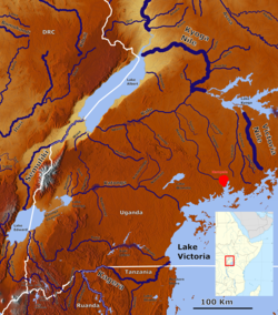
Murchison Falls National Park (MFNP) is a national park in Uganda and managed by the Ugandan Wildlife Authority. It is in north-western Uganda, spreading inland from the shores of Lake Albert, around the Victoria Nile, up to the Karuma Falls.

Nkusi River river in Uganda

The Nkusi River is in the Bunyoro sub-region, in the Western Region of Uganda.

Mayanja River river in Uganda

River Mayanja is a river in Uganda, East Africa.

Buliisa District District

Buliisa District is a district in Western Uganda. As with most Ugandan districts, Buliisa District is named after its "main town" Buliisa, where the district headquarters are located.

Sezibwa River river in Uganda

The Sezibwa River is a river in Central Uganda, in East Africa. The name is derived from the Luganda phrase "sizibwa kkubo", which translates into "my path cannot be blocked".

Pakuba in Northern Uganda, Uganda

Pakuba is a location in Northern Uganda.

Butiaba Place

Butiaba, sometimes spelled as Butyaba, is a town in the Western Region of Uganda.

Kiryandongo District District

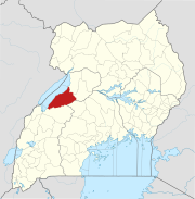
Kiryandongo District is a district in Western Uganda. Like many other Ugandan districts, it is named after its 'chief town', Kiryandongo, where the district headquarters are located.

River Muzizi river in Uganda

River Muzizi is a river in Uganda, in East Africa.

Lwajjali River river in Uganda

River Lwajjali is a river in Uganda, in East Africa.

Rwekunye–Apac–Aduku–Lira–Kitgum–Musingo Road is a road in the Northern Region of Uganda, connecting the towns of Masindi Port in Kiryandongo District to Apac in Apac District, Lira in Lira District, Acholibur in Pader District, Kitgum in Kitgum District, and Musingo in Lamwo District at the international border with South Sudan.

Rwekunye in Western Region of Uganda, Uganda

Rwekunye is a settlement in Kiryandongo District in the Western Region of Uganda.

Nkusi Hydroelectric Power Station

Nkusi Hydroelectric Power Station, also referred to as Nkusi Power Station, is a 9.6 MW (12,900 hp) hydroelectric power station under construction in the Western Region of Uganda.

References