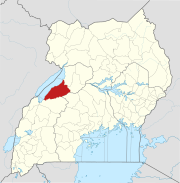
Hoima District is a district in Western Uganda. Like most other Ugandan districts, it is named after its main municipal centre, Hoima.

Masindi is a town in the Western Region of Uganda. It is on the road between Kampala and the Murchison Falls National Park. It is the site of the headquarters of the Masindi District.

Bugamba is an urban centre in the Western Region of Uganda. It is one of the trading centres in Mbarara District.
Kanungu is a town in the Western Region of Uganda. It is the location of the district headquarters for Kanungu District.
Nakapiripirit is a town in the Nakapiripirit District of the Northern Region of Uganda. It is the seat of the district headquarters. The town is an administrative unit of the district, at the level of a sub-county; one of the eight sub-counties in the district.
Sheema, also Sheema Municipality, is an urban centre in the Western Region of Uganda. It is the largest municipality in Sheema District.
Nwoya is a town in Nwoya District in the Northern Region of Uganda. It is the main municipal, administrative, and commercial centre of the district.
Rubirizi, sometimes spelled Rubiriizi, is a town in Rubirizi District, Ankole sub-region, Western Uganda. The town is the main municipal, administrative and commercial center of Rubirizi District. The district is named after the town.
Buloba is an urban area in Wakiso District in the Buganda Region of Uganda. The area is primarily a middle-class residential neighborhood.
Bukomero is a town in Ssingo County, Kiboga District, in the Central Region of Uganda.
Kigumba–Masindi–Hoima–Kabwoya Road is a road in the Western Region of Uganda, connecting the towns of Kigumba in Kiryandongo District, Masindi in Masindi District, Hoima in Hoima District and Kabwoya, in Kikuube District.
Kimwanyi is a neighborhood in Kira Municipality, Wakiso District, in the Buganda Region of Uganda. Kimwanyi also refers to Kimwanyi Parish, in Kira sub-county, Kyaddondo County, Wakiso District. It is one of the six parishes (wards) of Kira Municicipality, namely; Kimwanyi, Kira, Kyaliwajjala, Kireka, Bweyogerere and Kirinnya.
Muyembe is a town in the Eastern Region of Uganda.
Namayumba is a settlement in the Wakiso District in the Buganda Region of Uganda. The name also refers to "Namayumba sub-county", the location of Namayumba settlement.
Rubanda is a town in the extreme southwest of the Western Region of Uganda. It serves as the commercial, political and administrative center of Rubanda District.
Kijabijo is a neighborhood in Kira Town, in Wakiso District in the Buganda Region of Uganda.
Lwensinga is a town in the Buganda Region of Uganda.
Biso, also Biiso, is a town in the Western Region of Uganda. It is an urban center in the Buliisa District Administration. Biiso also refers to a sub-county in Uganda, where the town is located.
Kadama is a town in Kibuku District, in the Eastern Region of Uganda.
Nyapea, is a town in Zombo District, West Nile sub-region, in the Northern Region of Uganda.