Hoima is a city in the Western Region of Uganda. It is the main municipal, administrative, and commercial center of Hoima District. It is also the location of the palace of the Omukama of Bunyoro.
Kiboga is a town in the Central Region of Uganda. It is the main municipal, administrative, and commercial center of Kiboga District, and the district headquarters are located there.

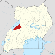
Kibaale is a town in the Western Region of Uganda. It is the main municipal, administrative, and commercial center of Kibaale District, and the district headquarters are located there.
Pabbo, sometimes spelled as Pabo, is a municipality in Amuru District of the Northern Region of Uganda.
Kagadi is a town in the Western Region of Uganda. It is the commercial and administrative headquarters of Kagadi District.
Hoima Regional Referral Hospital, commonly known as Hoima Hospital, is a hospital in the town of Hoima in Hoima District in the Western Region of Uganda. It is the referral hospital for the districts of Bulisa, Hoima, Kibaale, Kiryandongo, and Masindi.
Kibulala, Ssingo, commonly known as Kibulala, is a hill in Ssingo County, Kiboga District in Central Uganda. The hill rises approximately 1,250 metres (4,100 ft) above sea level. The name also applied to the village that sits on top of the hill and the Buganda cultural site located there.
Masulita is a town in the Wakiso District in the Central Region of Uganda.
Kigumba–Masindi–Hoima–Kabwoya Road is a road in the Western Region of Uganda, connecting the towns of Kigumba in Kiryandongo District, Masindi in Masindi District, and Hoima and Kabwoya in Hoima District.
The Kyenjojo–Kabwoya Road, in the Western Region of Uganda, connects the town of Kyenjojo in the Kyenjojo District with Kabwoya in the Hoima District. The road is part of the 238 kilometres (148 mi) Kyenjojo–Hoima–Masindi–Kigumba road corridor.
Kabwoya is a village in the Hoima District of the Western Region of Uganda.
Kaiso, is a settlement in Western Uganda.
Kiboga General Hospital, also Kiboga Hospital, Kiboga Main Hospital or Kiboga District Hospital, is a hospital in the Central Region of Uganda.
The Myanzi–Kassanda–Bukuya–Kiboga Road is a road in Uganda, connecting the towns of Myanzi, Kassanda and Bukuya in Mubende District, to Kiboga in Kiboga District.
Bukuya is a town in the Mubende District in the Central Region of Uganda.
Lwamata is a town in Ssingo County, Kiboga District, in the Central Region of Uganda.
Kakumiro is a town in the Western Region of Uganda. It is the main municipal, administrative, and commercial center of Kakumiro District, and the district headquarters are located there.
Nkusi Hydroelectric Power Station, also referred to as Nkusi Power Station, is a 9.6 MW (12,900 hp) hydroelectric power station in the Western Region of Uganda.
Kasenyi is a village in Ngedwo sub county, Buliisa District, in the Western Region of Uganda. It is the location of a "central processing facility" (CPF) of Uganda's oil fields in the Albertine Graben.
The Buhimba–Nalweyo–Kakindu–Bulamagi Road is a road in the Western Region of Uganda, connecting the town of Buhimba in Hoima District with the towns of Nalweyo, Kakindu and Bulamagi, in Kakumiro District.