Masindi

Last updated
Masindi
Masindi, Uganda.jpg
Uganda location map.svg
Red pog.svg
Masindi
Location in Uganda
Coordinates: 01°41′01″N31°43′20″E / 1.68361°N 31.72222°E / 1.68361; 31.72222
Country Flag of Uganda.svg Uganda
Region Western Region of Uganda
Sub-region Bunyoro sub-region
District Masindi District
Area
  Total140 sq mi (360 km2)
Elevation
4,026 ft (1,227 m)
Population
 (2020 Estimate)
  Total110,500 [1]
Sign post for Masindi Municipal Council Sign post for Masindi Municipal Council.jpg
Sign post for Masindi Municipal Council

Masindi is a town in the Western Region of Uganda. It is on the road between Kampala and the Murchison Falls National Park. It is the site of the headquarters of the Masindi District. [2]

Contents

Location

Masindi is approximately 211 kilometres (131 mi) northwest of Kampala, Uganda's capital and largest city, on an all-weather tarmac highway. [3] This location is approximately 57 kilometres (35 mi), by road, north-east of Hoima, the largest city in the Bunyoro sub-region. [4]

The coordinates of Masindi are 1°41'01.0"N, 31°43'20.0"E (Latitude:1.683611; Longitude:31.722222). [5] Masindi Town lies at an average elevation of1,227 metres (4,026 ft) above sea level. [6]

Population

According to the 2002 national census, the population of Masindi was about 28,300. In 2010, the Uganda Bureau of Statistics (UBOS) estimated the population at 43,000. In 2011, UBOS estimated the mid-year population at 45,400. [7] The national population census conducted in August 2014 put the population at 94,622. [8]

In 2020, UBOS estimated the mid-year population of Masindi Town at 110,000 people. The population agency calculated that the population of the town grew at an average rate of 2.72 percent annually, between 2014 and 2020. [1]

Historical population
YearPop.±%
19695,226    
19804,958−5.1%
199110,839+118.6%
200263,583+486.6%
201494,438+48.5%
2020110,500+17.0%
source: [1]

History

As capital of Bunyoro, Masindi was visited by Samuel and Florence Baker, British explorers and anti-slavery campaigners, from 25 April 1872 to 14 June 1873. The Baker expedition was forced to withdraw because of the hostility of the Omukama Kabaléga, the King of Bunyoro at the time. The White Fathers founded here a mission in the 1910s. [9] The town was developed as a commercial centre due to trade in cotton during the second half of the 19th century. [2]

During World War II, Masindi was the location of the second-largest refugee camp for Poles escaping from Soviet-occupied Poland in East Africa. [10] There were 3,635 people, including 1,759 children. [11] There was a Polish preschool, three primary schools, a general education liceum and a vocational school for girls. [12] Two Polish newspapers were issued in Masindi, Czuj Duch and Brzask. [13]

Points of interest

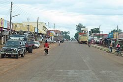
These additional points of interest are within the town limits or close to the edges of town: [2] (a) offices of Masindi Town Council (b) Masindi Hospital, a 200-bed public hospital administered by the Uganda Ministry of Health (c) Masindi Hotel, the oldest hotel in the country, built in 1923 and where Ernest Hemingway, Katharine Hepburn and Humphrey Bogart stayed (d) a branch of the National Social Security Fund (e) the main campus of the Kigumba Petroleum Institute, 44 kilometres (27 mi) northeast of Masindi (f) Kinyara Sugar Works, one of the three major manufacturers of refined sugar in Uganda, located 15 kilometres (9 mi) west of Masindi (g) Masindi Airport, a public airport, administered by the Civil Aviation Authority of Uganda. [14]

Challenges

A profile of the town written by the New Vision newspaper identified three major challenges. The first challenge was the inadequacy of income-generating projects outside of the town centre. Three out of four divisions in town; Kigulya, Karujubu and Nyagahya are unable to generate enough revenue to meet service demands. [2] The second major challenge is the inadequacy of sanitation services. The town had five public toilets, as of November 2013, and all of them were located in the town's Central division. Masindi is serviced by National Water and Sewerage Corporation, but the services are concentrated in the town centre. [2] The third major challenge for the town of Masindi is that of garbage disposal. The town lacked adequate funding to hire staff and purchase fuel to dispose of the town's garbage. However, the Central government had provided equipment to carry out the task. [2]

Education

The District Council equally joins the Government to promote Education for all its citizens in partnership with parents and others members of the community. As such, the Government's Education policy is to promote quality basic education by improving access by girls and boys, equity and retention in all Primary schools and other levels of learning.

See also

Related Research Articles

<span class="mw-page-title-main">Masindi District</span> District in Western Uganda, Uganda

Masindi District is a district in Western Uganda. Like many other Ugandan districts, it is named after its 'chief town' of Masindi, the location of the district headquarters.

Hoima is a city in the Western Region of Uganda. It is the main municipal, administrative, and commercial center of Hoima District. It is also the location of the palace of the Omukama of Bunyoro.

Kiboga is a town in the Buganda Region of Uganda. It is the main municipal, administrative, and commercial center of Kiboga District, and the district headquarters are located there.

Kayunga is a town in the Central Region of Uganda. It is the main municipal, administrative, and commercial center of Kayunga District.

<span class="mw-page-title-main">Kibaale</span> Place in Western Uganda, Uganda

Kibaale is a town in the Western Region of Uganda. It is the main municipal, administrative, and commercial center of Kibaale District, and the district headquarters are located there.

<span class="mw-page-title-main">Mubende</span> Place in Central Region of Uganda, Uganda

Mubende is a town in the Central Region of Uganda. It is the main municipal, administrative, and commercial center of Mubende District and is the location of the district headquarters.

Luweero is a town in the Central Region of Uganda. It is the main municipal, administrative, and commercial center of Luweero District.

Kakiri is a town located in Wakiso District in the Central Region of Uganda.

<span class="mw-page-title-main">Mukono Town</span> Urban centre in Uganda

Mukono Town is a municipality in Mukono District in the Central Region of Uganda. The town is administered by the Mukono Town Council. The district headquarters are located in this town.

Wakiso is a city in the Central Region of Uganda. It is the headquarters of Wakiso District.

<span class="mw-page-title-main">Buliisa District</span> Ugandan administrative district

Buliisa District is a district in Western Uganda. As with most Ugandan districts, Buliisa District is named after its "main town" Buliisa, where the district headquarters are located. Bugungu has 6 sub counties: Kigwera, Ngwedo, Buliisa, Butiaba, Kihungya, and Biiso. It also contain 3 town councils: Buliisa, Butiaba and Biiso.

Buliisa, also Bulisa, is a town in the Western Region of Uganda. It is the site of the headquarters of the Buliisa District. Neighborhoods within Buliisa Municipality include Wanseko and Kasenyi.

Lyantonde is a town in the southern part of the Central Region of Uganda. It is the main municipal, administrative, and commercial center of Lyantonde District.

Kagadi is a town in the Western Region of Uganda. It is the commercial and administrative headquarters of Kagadi District.

<span class="mw-page-title-main">Masindi Port</span> Ugandan town

Masindi Port is a town in the Western Region of Uganda. The name also applied to the sub-county, where the own sits and forms the sub-county headquarters.

Bukomero is a town in Ssingo County, Kiboga District, in the Central Region of Uganda.

Kigumba–Masindi–Hoima–Kabwoya Road is a road in the Western Region of Uganda, connecting the towns of Kigumba in Kiryandongo District, Masindi in Masindi District, Hoima in Hoima District and Kabwoya, in Kikuube District.

Namayumba is a settlement in the Wakiso District in the Buganda Region of Uganda. The name also refers to "Namayumba sub-county", the location of Namayumba settlement.

Kigorobya, is a town in the Western Region of Uganda. It is an urban center in the Hoima District Administration. Kigorobya also refers to a sub-county in Uganda, where the town is located.

<span class="mw-page-title-main">Kikuube District</span> Ugandan administrative district

Kikuube District is a district in the Western Region of Uganda. It is named after its main municipal centre, Kikuube.

References

  1. 1 2 3 Uganda Bureau of Statistics (14 June 2020). "Masindi Population Statistics" (Citypopulation.de Quoting Uganda Bureau of Statistics). Kampala: Citypopulation.de. Retrieved 29 April 2021.
  2. 1 2 3 4 5 6 Geoffrey Araali Mutegeki (5 October 2013). "Toilet Use In Buvuma Remains A Luxury - Study". New Vision . Kampala. Retrieved 22 June 2019.
  3. Google (29 April 2021). "Road Distance Between Kampala, Uganda And Masindi, Uganda" (Map). Google Maps . Google. Retrieved 29 April 2021.
  4. Google (29 April 2021). "Road Distance Between Hoima And Masindi In Uganda" (Map). Google Maps . Google. Retrieved 29 April 2021.
  5. Google (2 July 2015). "Location of Masindi Town" (Map). Google Maps . Google. Retrieved 2 July 2015.
  6. Floodmap (22 June 2019). "Elevation of Masindi Town". Floodmap.net. Retrieved 22 June 2019.
  7. UBOS. "Estimated Population of Masindi In 2002, 2010 & 2011" (PDF). Uganda Bureau of Statistics (UBOS). Archived from the original (PDF) on 7 July 2014. Retrieved 8 May 2014.
  8. UBOS (27 August 2014). "The Population of The Regions of the Republic of Uganda And All Cities And Towns of More Than 15,000 Inhabitants". Citypopulation.de Quoting Uganda Bureau of Statistics (UBOS). Retrieved 23 February 2015.
  9. To The Heart Of The Nile: Lady Florence Baker and the Exploration of Central Africa, by Pat Shipman
  10. Wróbel, Janusz (2003). Uchodźcy polscy ze Związku Sowieckiego 1942–1950 (in Polish). Łódź: Instytut Pamięci Narodowej. p. 151. ISBN   978-83-7629-522-0.
  11. Wróbel, p. 160
  12. Wróbel, pp. 167–169
  13. Wróbel, p. 173
  14. Uganda Civil Aviation Authority (2019). "About Masindi Airfield". Entebbe: Civil Aviation Authority of Uganda . Retrieved 22 June 2019.

01°41′01″N31°43′20″E / 1.68361°N 31.72222°E / 1.68361; 31.72222