Butiaba

Last updated

Butiaba
Uganda location map.svg
Red pog.svg
Butiaba
Map of Uganda showing the location of Butiaba
Placement on map is approximate.
Coordinates: 01°49′08″N31°19′33″E / 1.81889°N 31.32583°E / 1.81889; 31.32583 Coordinates: 01°49′08″N31°19′33″E / 1.81889°N 31.32583°E / 1.81889; 31.32583
CountryFlag of Uganda.svg  Uganda
Region Western Uganda
Sub-region Bunyoro sub-region
District Buliisa District
Elevation
622 m (2,041 ft)
Time zone UTC+3 (EAT)

Butiaba, is a town in the Western Region of Uganda. It is a fishing town and landing site on the shores of Lake Albert, in Uganda. [1]

Contents

Location

Butiaba is located on the eastern shores of Lake Albert, in Buliisa District, in the Bunyoro sub-region of Western Uganda. Butiaba is approximately 47.5 kilometres (30 mi), by road, southwest of the district headquarters at Buliisa. [2] Butiaba is located about 58 kilometres (36 mi) north of Hoima, the largest city in the Bunyoro sub-region. [3]

This location is approximately 257 kilometres (160 mi), by road, northwest of Kampala, Uganda's capital and largest city. [4] The coordinates of Butiaba are:1°49'08.0"N, 31°19'33.0"E (Latitude:1.818889; Longitude:31.325833). [5] Butiaba is situated at an average altitude of 622 metres (2,041 ft) above mean sea level. [6]

Overview

During the first half of the 20th century, Butiaba was an important transportation hub, where merchandise from eastern Democratic Republic of the Congo (DRC) and from South Sudan was transported by boat across Lake Albert to Butiaba Harbour. At Butiaba, merchandise was transported overland, through Masindi to Masindi Port. At Masindi Port, the produce would be loaded on barges, ferried across Lake Kyoga to Soroti. At Soroti, it would be loaded onto railway wagons for transportation by rail to Mombasa, Kenya, on the Indian Ocean, for export. Imported goods and merchandise were transported along the same route, in reverse. [7] [8]

When the East African Railways Corporation was dissolved in the 1970s, Butiaba's prominence declined and the harbour became dormant. A significant amount of petroleum deposits has since been discovered in the ground and under the lake near Butiaba. Reviving Butiaba Harbour to play a role in the transportation of equipment, manpower, and petroleum is being considered. [7] [8]

Population

As of July 2014, the exact population of Butiaba was not known. The national population census in Uganda took place in August 2014 but results are yet to come out. [9]

Point of interest

Lake Albert - One of the lakes in the Western Rift Valley. The international border between the DRC and Uganda runs through it. [5]

See also

Related Research Articles

Hoima District District in Uganda

Hoima District is a district in Western Uganda. Like most other Ugandan districts, it is named after its main municipal centre, Hoima.

Masindi District District in Uganda

Masindi District is a district in Western Uganda. Like many other Ugandan districts, it is named after its 'chief town' of Masindi, the location of the district headquarters.

Masindi Place in Western Region of Uganda, Uganda

Masindi is a town in the Western Region of Uganda. It is on the road between Kampala and the Murchison Falls National Park. It is the site of the headquarters of the Masindi District.

Murchison Falls National Park

Murchison Falls National Park (MFNP) is a national park in Uganda and managed by the Ugandan Wildlife Authority. It is in north-western Uganda, spreading inland from the shores of Lake Albert, around the Victoria Nile, up to the Karuma Falls.

Hoima District capital in Western Region, Uganda

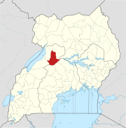
Hoima is a city in the Western Region of Uganda. It is the main municipal, administrative, and commercial center of Hoima District. It is also the location of the palace of the Omukama of Bunyoro.

The Roman Catholic Diocese of Hoima is a diocese located in the city of Hoima in the Ecclesiastical province of Mbarara in Uganda.

Masindi Hotel is a hotel in Masindi, the district headquarters of Masindi District, in western Uganda.

Buliisa District Ugandan administrative district

Buliisa District is a district in Western Uganda. As with most Ugandan districts, Buliisa District is named after its "main town" Buliisa, where the district headquarters are located. Bugungu has 6 sub counties (Kigwera, Ngwedo, Buliisa, Butiaba, Kihungya, and Biiso and 3 town councils.

Buliisa Ugandan town

Bulisa, also Bulisa, is a town in the Western Region of Uganda. It is the site of the headquarters of the Buliisa District. Neighborhoods within Buliisa Municipality include Wanseko and Kasenyi.

Masindi Port Ugandan town

Masindi Port is a town in the Western Region of Uganda. The name also applied to the sub-county, where the own sits and forms the sub-county headquarters.

Kiryandongo District District in Uganda

Kiryandongo District is a district in Western Uganda. Like many other Ugandan districts, it is named after its 'chief town', Kiryandongo, where the district headquarters are located.

The Uganda National Roads Authority (UNRA) is a government agency mandated to develop and maintain the national roads network, advise the government on general roads policy, contribute to the addressing of national transport concerns, and perform certain other functions. UNRA is charged with, among other things, the selection of contractors, the supervision of construction, the scheduling of maintenance, and the prioritization of national road works.

Hoima–Butiaba–Wanseko Road is a road in the Western Region of Uganda, connecting the city of Hoima and the towns of Butiaba, Buliisa, and Wanseko on the shores of Lake Albert. This is one of Uganda's critical oil roads because it facilitates oil exploration in the Albertine Graben, as well as tourism, due to its proximity to Kabalega National Park.

Wanseko Place in Uganda

Wanseko, is a settlement in Western Uganda.

Kabwoya Place in Western Region of Uganda, Uganda

Kabwoya is a village in the Kikuube District of the Western Region of Uganda.

Masindi General Hospital Hospital in Western Region, Uganda

Masindi General Hospital, also Masindi Government Hospital or Masindi Hospital, is a hospital in the Western Region of Uganda.

Nkusi Hydroelectric Power Station Dam in Nkusi Falls, Hoima District

Nkusi Hydroelectric Power Station, also referred to as Nkusi Power Station, is a 9.6 MW (12,900 hp) hydroelectric power station in the Western Region of Uganda.

Kasenyi, Buliisa Place in Western Region of Uganda, Uganda

Kasenyi is a village in Ngedwo sub county, Buliisa District, in the Western Region of Uganda. It is the location of a "central processing facility" (CPF) of Uganda's oil fields in the Albertine Graben.

Kikuube District is a district in the Western Region of Uganda. It is named after its main municipal centre, Kikuube.

Masindi–Biso Road is a road in the Western Region of Uganda, connecting the city of Masindi, in Masindi District and the town of Biso, in Buliisa District in the oil-rich Albertine Graben.

References

  1. FAO News (2018). "ASTF Project helping Lake Albert youth through cage fish farming". FAO Regional Office for Africa. Accra, Ghana. Retrieved 9 August 2021.
  2. Google (9 August 2021). "Road Distance Between Buliisa District Headquarters, Buliisa, Uganda And Butiaba, Uganda With Map" (Map). Google Maps . Google. Retrieved 9 August 2021.
  3. Google (9 August 2021). "Road Distance Between Hoima City, Uganda And Butiaba, Uganda With Map" (Map). Google Maps . Google. Retrieved 9 August 2021.
  4. Google (9 August 2021). "Road Distance Between Kampala Road, Kampala, Uganda And Butiaba, Uganda With Interactive Map" (Map). Google Maps . Google. Retrieved 9 August 2021.
  5. 1 2 Google (9 August 2021). "Location of Butiaba Town Council, Buliisa District, Western Region, Uganda" (Map). Google Maps . Google. Retrieved 9 August 2021.
  6. Fallingrain (9 August 2021). "Elevation of Butiaba, Uganda". Fallingrain.com. Retrieved 9 August 2021.
  7. 1 2 Andrew Bagala (22 April 2008). "Butiaba Port To Be Redeveloped As Route For Oil Transportation". Daily Monitor via AllAfrica.com . Retrieved 18 July 2014.
  8. 1 2 New Vision (October 2020). "Uganda inches closer to oil revenue". New Vision . Kampala, Uganda. Retrieved 9 August 2021.
  9. Ninsiima, Racheal (14 July 2013). "Uganda Census Planned for 2014". The Observer (Uganda) . Retrieved 18 July 2014.