Mukono is one of the districts in the Central Region of Uganda. The town of Mukono is home to the district's main commercial center and district headquarters.

Wakiso District is a district in the Central Region of Uganda that partly encircles Kampala, Uganda's capital city. The town of Wakiso is the site of the district headquarters. Kira, the country's second largest city and suburb of Kampala, is in the district.

Masindi District is a district in Western Uganda. Like many other Ugandan districts, it is named after its 'chief town' of Masindi, the location of the district headquarters.
Masindi is a town in the Western Region of Uganda. It is on the road between Kampala and the Murchison Falls National Park. It is the site of the headquarters of the Masindi District.
Arua is a city and commercial centre within the Arua District in the Northern Region of Uganda.
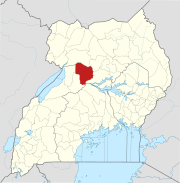
Kayunga is a town in the Central Region of Uganda. It is the main municipal, administrative, and commercial center of Kayunga District.
Mpigi is a town in Mawokota County, Mpigi District, in Central Uganda. Mpigi is the municipal, administrative and commercial headquarters of Mpigi District. The district is named after the town.
Nakasongola is a town in Nakasongola District in the Central Region of Uganda. The town is the site of the district headquarters.
Luweero is a town in the Central Region of Uganda. It is the main municipal, administrative, and commercial center of Luweero District.
Kasangati is a town in Nangabo sub-county, Wakiso District in the Central Region of Uganda. It also serves as the headquarters for Kyadondo County. The town is multi-lingual and is a "melting pot" of diverse cultures.
Kakiri is a town located in Wakiso District in the Central Region of Uganda.

Buliisa District is a district in Western Uganda. As with most Ugandan districts, Buliisa District is named after its "main town" Buliisa, where the district headquarters are located. Bugungu has 6 sub counties Kigwera, Ngwedo, Buliisa, Butiaba, Kihungya, and Biiso and 3 town councils.
Buliisa, also Bulisa, is a town in the Western Region of Uganda. It is the site of the headquarters of the Buliisa District. Neighborhoods within Buliisa Municipality include Wanseko and Kasenyi.
Kigumba is a town in Kiryandongo District, northwestern Uganda. It is one of the urban centers in the district. The other urban centres in Kiryandongo District include: (a) Karuma b) Kiryandongo (c) Bweyale and (d) Masindi Port.
Butiaba, is a town in the Western Region of Uganda. It is a fishing town and landing site on the shores of Lake Albert, in Uganda.
Kiryandongo is a town in the Western Region of Uganda. It is the main municipal, administrative, and commercial center of Kiryandongo District.
Masulita is a town in Wakiso District in the Central Region of Uganda. As of April 2021 Masulita is one of four town councils in the district.
Rwekunye is a settlement in Kiryandongo District in the Western Region of Uganda.
Kigumba–Masindi–Hoima–Kabwoya Road is a road in the Western Region of Uganda, connecting the towns of Kigumba in Kiryandongo District, Masindi in Masindi District, Hoima in Hoima District and Kabwoya, in Kikuube District.
Kikuube District is a district in the Western Region of Uganda. It is named after its main municipal centre, Kikuube.