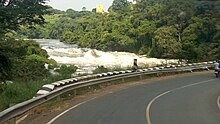
Karuma

Last updated
Karuma
Karuma falls junction.jpg
Uganda location map.svg
Red pog.svg
Karuma
Location in Uganda
Coordinates: 02°15′16″N32°14′37″E / 2.25444°N 32.24361°E / 2.25444; 32.24361
Country Flag of Uganda.svg Uganda
Region Western Uganda
Sub-region Bunyoro sub-region
District Kiryandongo District
Elevation
3,468 ft (1,057 m)

Karuma is a settlement in the Western Region of Uganda. [1]

Contents

Location

Karuma is in Kiryandongo District, Bunyoro sub-region. The town is approximately 2.7 kilometres (1.7 mi), by road, north of Karuma Falls. [2] The town is also approximately 11 kilometres (6.8 mi), by road, west of Kamdini, on the Lira–Kamdini–Karuma Road. [3] This location is approximately 261 kilometres (162 mi) north of Kampala, Uganda's capital and largest city., [4] The coordinates of the town are 2°15'16.0"N, 32°14'37.0"E (Latitude:2.254445; Longitude:32.243611). [5]

Overview

Karuma Bridge KARUMA BRIDGE.jpg
Karuma Bridge

Karuma is where the Lira–Kamdini–Karuma Road connects to the Kampala–Karuma Road and the Karuma–Olwiyo–Pakwach–Nebbi–Arua Road. [6]

See also

Related Research Articles

<span class="mw-page-title-main">Murchison Falls National Park</span> National park in Western Region, Uganda

Murchison Falls National Park (MFNP) is a national park in Uganda managed by the Ugandan Wildlife Authority. Located in north-western Uganda, it spreads inland from the shores of Lake Albert, around the Victoria Nile, up to the Karuma Falls.

<span class="mw-page-title-main">Kiruhura, Uganda</span> Place in Western Region, Uganda

Kiruhura is a town in the Western Region of Uganda. It is the largest town in Kiruhura District and the site of the district headquarters.

<span class="mw-page-title-main">Masindi Port</span> Ugandan town

Masindi Port is a town in the Western Region of Uganda. The name also applied to the sub-county, where the own sits and forms the sub-county headquarters.

The Karuma Hydroelectric Power Station is a 600 MW hydroelectric power project under construction in Uganda. When completed, it will be the largest power-generating installation in the country.

Karuma Falls is a town in Western Region of Uganda.

Kole is a town in Northern Uganda. It is the main municipal, administrative and commercial center of Kole District. The district is named after the town.

Kiryandongo is a town in the Western Region of Uganda. It is the main municipal, administrative, and commercial center of Kiryandongo District.

Kigumba Petroleum Institute, also referred to as Uganda Petroleum Institute or as Uganda Petroleum Institute, Kigumba (UPIK), is a government-owned, national center for training, research and consultancy in the field of petroleum exploration, recovery, refinement and responsible utilization in Uganda.

The Acholibur–Gulu–Olwiyo Road is a road in the Northern Region of Uganda, connecting the town of Acholibur to the city of Gulu and the town of Olwiyo.

Olwiyo is a town in Nwoya District in the Northern Region of Uganda.

Rwekunye is a settlement in Kiryandongo District in the Western Region of Uganda.

The Soroti–Dokolo–Lira Road is a road in Uganda, connecting the towns of Soroti in Soroti District, Dokolo in Dokolo District, and Lira in Lira District.

The Kamdini–Gulu Road, also known as the Gulu–Kamdini Road, is a road in the Northern Region of Uganda, connecting the town of Kamdini with Gulu, the largest city in the Northern Region.

Kamdini, also referred to as Kamdini Corder, is a town in the Northern Region of Uganda.

The Lira–Kamdini–Karuma Road, also known as the Karuma–Kamdini–Lira Road, is a road in the Northern Region of Uganda, connecting the town of Lira, in Lira District, with the towns of Kamdini and Karuma, both in Oyam District.

<span class="mw-page-title-main">Kampala–Entebbe Road</span> Road in Uganda

The Kampala–Entebbe Road, also known as the Entebbe–Kampala Road or the Entebbe Road, is a road in the Central Region of Uganda, connecting the capital city of Kampala and Entebbe International Airport.

Palenga is a town in the Omoro District in the Northern Region of Uganda. It is the site of the district headquarters.

Rubanda is a town in the extreme southwest of the Western Region of Uganda. It serves as the commercial, political and administrative center of Rubanda District.

The Karuma–Kawanda High Voltage Power Line is a high voltage electricity power line, under construction, connecting the high voltage substation at Karuma Hydroelectric Power Station, in the Western Region of Uganda, to another high voltage substation at Kawanda, in the Central Region of Uganda.

The Kampala–Gulu Highway, also Kampala–Gulu Road, is a road connecting Uganda's capital city of Kampala, in the Central Region, with the city of Gulu, the largest urban centre in the country's Northern Region.

References

  1. Karuma
  2. GFC (6 January 2016). "Distance between Karuma, Northern Region, Uganda and Karuma Falls, Kiryandongo, Western Region, Uganda". Globefeed.com (GFC). Retrieved 6 January 2016.
  3. GFC (6 January 2016). "Distance between Karuma, Northern Region, Uganda and Kamdini, Northern Region, Uganda". Globefeed.com (GFC). Retrieved 6 January 2016.
  4. GFC (6 January 2016). "Distance between Karuma, Northern Region, Uganda and Kampala, Central Region, Uganda". Globefeed.com (GFC). Retrieved 6 January 2016.
  5. Google (6 January 2016). "Location of Karuma At Google Maps" (Map). Google Maps . Google. Retrieved 6 January 2016.
  6. Julius Ocungi, and Patrick Okaba (12 July 2015). "Uganda: MP Otto Leads Anti-Mbabazi Demonstration". Daily Monitor via AllAfrica.com . Kampala. Retrieved 6 January 2016.

02°15′16″N32°14′37″E / 2.25444°N 32.24361°E / 2.25444; 32.24361