Nakasongola

Last updated
Nakasongola
Uganda location map.svg
Red pog.svg
Nakasongola
Location in Uganda
Coordinates: 01°18′54″N32°27′54″E / 1.31500°N 32.46500°E / 1.31500; 32.46500
Country Flag of Uganda.svg Uganda
Region Central Region of Uganda
District Nakasongola District
Elevation
3,810 ft (1,160 m)
Population
 (2020 Estimate)
  Total11,700 [1]

Nakasongola is a town in Nakasongola District in the Central Region of Uganda. The town is the site of the district headquarters. [2]

Contents

Location

Nakasongola is approximately 118 kilometres (73 mi) north of Kampala, the capital and largest city of Uganda, on an all-weather tarmac highway between Kampala and Masindi. [3] The coordinates of the town are 1°18'54.0"N, 32°27'54.0"E (Latitude:1.3150; Longitude:32.4650). [4]

Population

The population of Nakasongola Town was estimated at 6,500 during the 2002 national census. In 2006, the population was estimated at 6,920. [5] In the 2014 national population census and household survey, the population of Nakasongola was enumerated at 10,289. [6]

In 2015, Uganda Bureau of Statistics (UBOS) estimated the town's population at 10,100. In 2020, the population agency estimated the mid-year population of Nakasongola Town at 11,700 people, of whom 6,200 (53 percent) were male and 5,500 (47 percent) were female. UBOS calculated the population growth rate of the town to average 2.98 percent per year, between 2015 and 2020. [1]

Historical population
YearPop.±%
20026,500    
20066,920+6.5%
201410,289+48.7%
201510,100−1.8%
202011,700+15.8%
source: [1] [5] [6]

Points of interest

The following additional points of interest are located in the town of Nakasongola or near its borders: (a) the offices of Nakasongola Town Council (b) the offices of Nakasongola District local government (c) Nakasongola Air Force Base, part of the Uganda People's Defence Force (UPDF) (d) Nakasongola Airport, located on Nakasongola Air Force Base (e) Uganda Military Air Force Academy, a training school of the UPDF Air Force, also located on Nakasongola Air Force Base [7] (f) Uganda Air Defence and Artillery School, another training school of the UPDF, also located on Nakasongola Air Force Base (g) Nakasongola central market (h) A branch of PostBank Uganda and (i) Ziwa Rhino Sanctuary, approximately 50 kilometres (31 mi), by road, northwest of Nakasongola, on the Nakasongola-Masindi Highway. [8]

See also

Related Research Articles

<span class="mw-page-title-main">Luweero District</span> District in Central Region of Uganda, Uganda

Luweero District is a district in the Central Region of Uganda. Luweero is the site of the district headquarters.

<span class="mw-page-title-main">Fort Portal</span> Place in Western Region, Uganda

Fort Portal or Kabarole is a city located in the Western Region of Uganda. It is the seat of both Kabarole District and historically of the Toro Kingdom.

<span class="mw-page-title-main">Lira, Uganda</span> Place in Northern Region of Uganda, Uganda

Lira is a city in the Northern Region of Uganda. It is the main municipal, administrative, and commercial centre of Lira District.

<span class="mw-page-title-main">Masindi</span> Place in Western Region of Uganda, Uganda

Masindi is a town in the Western Region of Uganda. It is on the road between Kampala and the Murchison Falls National Park. It is the site of the headquarters of the Masindi District.

<span class="mw-page-title-main">Masaka</span> Place in Buganda Region, Uganda

Masaka is a city in the Buganda Region of Uganda, west of Lake Victoria. The city is the headquarters of Masaka District.

Yumbe is a town in the Northern Region of Uganda. It is the district headquarters of Yumbe District.

Mpigi is a town in Mawokota County, Mpigi District, in Central Uganda. Mpigi is the municipal, administrative and commercial headquarters of Mpigi District. The district is named after the town.

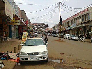
Luweero is a town in the Central Region of Uganda. It is the main municipal, administrative, and commercial center of Luweero District.

Kakiri is a town located in Wakiso District in the Central Region of Uganda.

<span class="mw-page-title-main">Mukono Town</span> Urban centre in Uganda

Mukono Town is a municipality in Mukono District in the Central Region of Uganda. The town is administered by the Mukono Town Council. The district headquarters are located in this town.

<span class="mw-page-title-main">Buliisa District</span> Ugandan administrative district

Buliisa District is a district in Western Uganda. As with most Ugandan districts, Buliisa District is named after its "main town" Buliisa, where the district headquarters are located. Bugungu has 6 sub counties Kigwera, Ngwedo, Buliisa, Butiaba, Kihungya, and Biiso and 3 town councils.

Lugazi is a town in the Buikwe District of the Central Region of Uganda. The town is also called "Kawolo", and the two names are interchangeably used by the local inhabitants.

Mpondwe is a town in the Western Region of Uganda.

Nkokonjeru is a town council in Buikwe District in the Central Region of Uganda with villages such as: Namaliiri, Kigulu, Mulajje, Naziwanga, Ndolwa, Buira, Bukasa, Wabiduuku, Nsuube and Nkokonjeru Central. The town's name means "White Chicken" in English.

Masindi Port is a town in the Western Region of Uganda. The name also applied to the sub-county, where the own sits and forms the sub-county headquarters.

The Uganda Military Engineering College (UMEC), also University of Military Science and Technology (UMST), is a tertiary institution of higher learning, that instructs qualified military officers and technicians in various fields of engineering and science. The university is administered by the Uganda People's Defense Force (UPDF), under the auspices of the Uganda Ministry of Defence.

Nakasongola Airport is an airport in Uganda. As of 2013, it was one of the 47 airports in the country. It is the intended headquarters of the Air Wing of the Uganda People's Defense Force and, along with Entebbe Airport, Gulu Airport, Jinja Airport and Soroti Airport, is one of the five national military airports.

Rwekunye is a settlement in Kiryandongo District in the Western Region of Uganda.

The Wabigalo–Nakasongola–Sasira Road is a road in the Central Region of Uganda, connecting the town of Nakasongola with the towns of Wabigalo and Sasira on the Kampala–Gulu Highway. An extension from Nakasongola links to Nakasongola Air Force Base.

References

  1. 1 2 3 Uganda Bureau of Statistics (14 June 2020). "Estimated Population of Nakasongola Town" (Citypopulation.de Quoting Uganda Bureau of Statistics). Citypopulation.de. Retrieved 13 January 2021.
  2. Kakembo, Titus (18 March 2011). "Nakasongola a town of dreams". New Vision . Kampala. Retrieved 3 March 2018.
  3. Google (13 January 2021). "Distance between Post Office Building, Kampala Road, Kampala, Uganda and Nakasongola, Central Region, Uganda" (Map). Google Maps . Google. Retrieved 13 January 2021.
  4. Google (13 January 2021). "Location of Nakasongola, Uganda" (Map). Google Maps . Google. Retrieved 13 January 2021.
  5. 1 2 "Estimated Population of Nakasongola Town In 2006". Mongabay.com. 2006. Retrieved 13 January 2021.
  6. 1 2 Uganda Bureau of Statistics (November 2014). "National Population and Housing Census 2014: Provisional Results: Appendix 3 - Households and Population by Subcounty/Town Council/Urban Division and Sex, 2014" (PDF). Uganda Bureau of Statistics. Archived from the original (Archived from the original on 10 January 2017) on 2017-01-10. Retrieved 13 January 2021.
  7. MSD (2 August 2017). "Military School Directory: Uganda Military Air Force Academy, Nakasongola, Uganda". Military School Directory (MSD). Retrieved 2 August 2017.
  8. PUGS (2 August 2017). "Where to Sleep in Ziwa Rhino Sanctuary - Uganda Safari News". Kampala: Prime Uganda Safaris (PUGS). Retrieved 2 August 2017.

Coordinates: 01°18′54″N32°27′54″E / 1.31500°N 32.46500°E / 1.31500; 32.46500