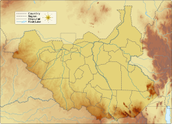
Kidepo River

Last updated
Kidepo River
Kidepo Riverbed.jpg
South Sudan topographic map.svg
Etymology"to pick" in Karamajong
Location
Country Uganda, South Sudan
Physical characteristics
SourcePirre
 - location Kaabong, Uganda
 - coordinates 3°54′04″N34°00′42″E / 3.901167°N 34.011667°E / 3.901167; 34.011667
 - elevation1,300 m (4,300 ft)
Mouth White Nile
 - location South Sudan
Discharge 
 - minimum0 m3/s (0 cu ft/s)
Basin features
Tributaries 
 - right Narus River

The Kidepo River is a seasonal river along the Kidepo Valley in the Karamoja region of Uganda, and in East Equatoria area of South Sudan.

Karamoja

Karamoja sub-region, commonly known as Karamoja, is a region in Uganda.

Uganda republic in East Africa

Uganda, officially the Republic of Uganda, is a landlocked country in East-Central Africa. It is bordered to the east by Kenya, to the north by South Sudan, to the west by the Democratic Republic of the Congo, to the south-west by Rwanda, and to the south by Tanzania. The southern part of the country includes a substantial portion of Lake Victoria, shared with Kenya and Tanzania. Uganda is in the African Great Lakes region. Uganda also lies within the Nile basin, and has a varied but generally a modified equatorial climate.

South Sudan country in Africa

South Sudan, officially known as the Republic of South Sudan, is a landlocked country in East-Central Africa. The country gained its independence from the Republic of the Sudan in 2011, making it the newest country with widespread recognition. Its capital and largest city is Juba.

See also

Seasonal rivers of Uganda include Agago river,Lumansi river, and Kidepo river

Related Research Articles

White Nile river in Africa and tributary of the Nile River

The White Nile is a river in Africa, one of the two main tributaries of the Nile; the other is the Blue Nile. The name comes from colouring due to clay carried in the water.

Nalubaale Hydroelectric Power Station dam and lake

Nalubaale Power Station, formerly known as Owen Falls Dam, is a hydroelectric power station across the White Nile near to its source at Lake Victoria in Uganda. Nalubaale is the Luganda name for Lake Victoria.

Kidepo Valley National Park national park in Uganda

Kidepo Valley National Park is a 1,442 square kilometres (557 sq mi) national park in the Karamoja region in northeast Uganda. Kidepo is rugged savannah, dominated by the 2,750 metres (9,020 ft) Mount Morungole and transected by the Kidepo and Narus rivers.

The Ketebo people is an ethnic group in South Sudan. The Ketebo live in Bira, which is one of the Payams of Kidepo County, Torit, Eastern Equatoria State of South Sudan. Their land is Bira which include Kalabe, Koriang, Toomodo, Irobi, Morunyang, Lorife, Ibakany, Tabak lo Lokure, Napeyase, Nakoringole, Naitahapel, Kamulach, Okosio, Naurkori, Namosingo, Ofi, Otome, Arata, Lojilingare, Lofus, Lorum, Ateda,Madiel and Lonyili Mountain in Kidepo county of Torit, Eastern Equatoria state in South Sudan. The Ketebo people are also found in Lotukei, Kikilai, Petalado, Lorema in Didinga Corridor and in Lokori, Napotpot and Karenga, Uganda. Ketebo is one of the smallest tribes in South Sudan and they speak Oketeboi. The Ketebo in Uganda side are called Mening, which is also one of the smallest tribes in Uganda. The population of this ethnic group is over 18,000.Template:Manna Sudan Assessment 2010. Economic Activity. The Ketebo people were previously pastorolist in nature but due to change in climate and external influence from the neighbouring communities they are now practicing cultivation system with sorghum, maize and sasemi as main crop grown most of the season.

Kaabong District District in Uganda

Kaabong District is a district in the Northern Region of Uganda. The district headquarters are in the town of Kaabong.

Mount Morungole mountain in Uganda

Mount Morungole lies within the Kidepo Valley National Park, north-east Uganda, Africa. It is in the rugged, semi-arid Karamoja province near the border with the Sudan. Neighbouring peaks are Mount Zulia, and the Labwor and Dodoth Hills reach heights in excess of 2,000 meters.

The Garamba forest tree frog, Leptopelis oryi, is a species of frog in the family Arthroleptidae found in the Democratic Republic of the Congo, Uganda, and possibly Sudan. Its natural habitats are moist savanna, subtropical or tropical moist shrubland, subtropical or tropical seasonally wet or flooded lowland grassland, rivers, and intermittent freshwater marshes.

Foxy cisticola species of bird

The foxy cisticola is a species of bird in the Cisticolidae family.

Montane white-toothed shrew species of mammal

The montane white-toothed shrew is a species of mammal in the family Soricidae. It is found in Kenya, South Sudan, Tanzania, and Uganda. Its natural habitats are subtropical or tropical moist montane forest and subtropical or tropical seasonally wet or flooded lowland grassland. It is threatened by habitat loss.

Kidepo Airport airport in Uganda

Kidepo Airport is an airfield in Northern Region, Uganda. The airport is at Lomej, approximately 3 kilometres (2 mi) south of the headquarters of Kidepo Valley National Park, and 456 kilometres (283 mi) northeast of Entebbe International Airport, the country’s largest civilian and military airport.

Ik is one of the Kuliak languages of northeastern Uganda. The Kuliak languages form their own branch of the Nilo-Saharan language family. With the other two Kuliak languages being moribund, Ik may soon be the sole remaining language of its family. Ik is noted by UNESCO as "severely endangered".

Budi County in Namorunyang State, South Sudan

Budi County is an administrative area of Namorunyang State. Before the reorganisation of states in 2015, it was a part of Eastern Equatoria state in South Sudan, with headquarters in Chukudum.

The Narus River may refer to:

Narus River, Uganda river in South Sudan

The Narus River flows in a northwesterly direction through the southern portion of Kidepo Valley National Park in northern Uganda, joining the larger Kidepo River near Komoloich, about 13 kilometres (8.1 mi) after entering Eastern Equatoria state of South Sudan. The name Narus is derived from the Karamajong word for mud.

Kidepo Game Reserve

The Kidepo Game Reserve is a protected area located in Bira, Kidepo Valley County, Eastern Equatoria State, South Sudan, Africa. Three quarters of the Kidepo Valley Reserve park is in Bira, which is inhabited by the Ketebo people and the word "Kidepo" come from the Ketebo word "Kidebo", which mean "Help us". However, Sudan deployed some game rangers in Bira during 1976 – 1983 immediately the war broke out in 1983. With an area of 1200 Km2 this reserve is located 4° 04'N and 33° 28'E on the South Sudan/Uganda border where it forms a contiguous ecosystem with Uganda's Kidepo Valley National Park. Main mammal species of the reserve include, among others, elephants, wild dogs, lions, cheetahs, leopards, hyenas, lesser kudu, buffalos, and Giraffe. The present conservation status of these and many other mammals, birds, reptiles and amphibians is not known. It is likely that due to the protracted war and many other conservation challenges listed below the numbers of wildlife have been reduced in a similar way as those in 80ma, Nimule and Southern National Parks. It is a game reserve and Important Bird Area. The 1,200 square kilometres (460 sq mi) savannah grassland and woodland habitat features key species of Heuglin's francolin and elephant.

Maneless zebra subspecies of mammal

The maneless zebra is a subspecies of the plains zebra, spread over the northern parts of eastern Africa. It ranges in north-west Kenya, from Uasin Gishu and Lake Baringo to the Karamoja district of Uganda. It is also found in eastern South Sudan, east of the Nile River, for example in Boma National Park. It is the northernmost subspecies of the plains zebra.

Karenga, Uganda Place in Uganda

Karenga is a town in the Northeast of the Karamoja region of Uganda. It is known as one of the primary gateways into Kidepo Valley National Park. Karenga town is composed of various tribes both from Acholi and karamoja with vast languages and even the south Sudanese 'Mening quarters' Karenga are one of the most proud lucky farmers in nomadic karamoja and the soil supports growth of various food crops for subsistence home stead use.