
Burkina Faso is a landlocked Sahel country that shares borders with six nations. It lies between the Sahara desert and the Gulf of Guinea, south of the loop of the Niger River, mostly between latitudes 9° and 15°N, and longitudes 6°W and 3°E. The land is green in the south, with forests and fruit trees, and semi-arid in the north. Most of central Burkina Faso lies on a savanna plateau, 198–305 metres (650–1,001 ft) above sea level, with fields, brush, and scattered trees. Burkina Faso's game preserves – the most important of which are Arly, Nazinga, and W National Park—contain lions, elephants, hippopotamus, monkeys, common warthogs, and antelopes. Previously the endangered painted hunting dog, Lycaon pictus occurred in Burkina Faso, but, although the last sightings were made in Arli National Park, the species is considered extirpated from Burkina Faso.

Chad is one of the 47 landlocked countries in the world and is located in North Central Africa, measuring 1,284,000 square kilometers (495,755 sq mi), nearly twice the size of France and slightly more than three times the size of California. Most of its ethnically and linguistically diverse population lives in the south, with densities ranging from 54 persons per square kilometer in the Logone River basin to 0.1 persons in the northern B.E.T. (Borkou-Ennedi-Tibesti) desert region, which itself is larger than France. The capital city of N'Djaména, situated at the confluence of the Chari and Logone Rivers, is cosmopolitan in nature, with a current population in excess of 700,000 people.

Khartoum or Khartum is the capital of Sudan. With a population of 6,344,348, Khartoum's metropolitan area is the largest in Sudan.

The Nile is a major north-flowing river in northeastern Africa. It flows into the Mediterranean Sea. The Nile is the longest river in Africa and has historically been considered the longest river in the world, though this has been contested by research suggesting that the Amazon River is slightly longer. Of the world's major rivers, the Nile is one of the smallest, as measured by annual flow in cubic metres of water. About 6,650 km (4,130 mi) long, its drainage basin covers eleven countries: the Democratic Republic of the Congo, Tanzania, Burundi, Rwanda, Uganda, Kenya, Ethiopia, Eritrea, South Sudan, Sudan, and Egypt. In particular, the Nile is the primary water source of Egypt, Sudan and South Sudan. Additionally, the Nile is an important economic river, supporting agriculture and fishing.

Sudan is located in Northeast Africa. It is bordered by Egypt to the north, the Red Sea to the northeast, Eritrea and Ethiopia to the east, South Sudan to the south, the Central African Republic to the southwest, Chad to the west and Libya to the northwest. Sudan is the third largest country in Africa, after Algeria and the Democratic Republic of the Congo. It was the largest country on the continent until South Sudan split off from it in 2011.

Ethiopia is located in the Horn of Africa. It is bordered by Eritrea to the north, Djibouti and Somalia to the east, Sudan and South Sudan to the west, and Kenya to the south. Ethiopia has a high central plateau, the Abyssinian Highlands that varies from 1,290 to 3,000 m above sea level, with some 25 mountains whose peaks rise over 4,000 meters (13,200ft), the highest being Ras Dashen at 4,543 meters (14,538ft).

The Sudd is a vast swamp in South Sudan, formed by the White Nile's Baḥr al-Jabal section. The Arabic word sudd is derived from sadd, meaning "barrier" or "obstruction". The term "the sudd" has come to refer to any large solid floating vegetation island or mat. The area which the swamp covers is one of the world's largest wetlands and the largest freshwater wetland in the Nile Basin.

Malakal is a city in South Sudan, serving as the capital of Upper Nile State, South Sudan, along the White Nile River. It also serves as the headquarter of Malakal county and it used to be the headquarter of Upper Nile Region from the 1970s to the late 1990s.

The Toposa are an ethnic group in South Sudan, living in the Greater Kapoeta region of the erstwhile Eastern Equatoria state. They have traditionally lived by herding cattle, sheep and goats, and in the past were involved in the ivory trade. They have a tradition of constant low-level warfare, usually cattle raids, against their neighbors.

The Northern Congolian forest–savanna mosaic is a forest and savanna ecoregion of central Africa. It extends east and west across central Africa, covering parts of Cameroon, Central African Republic, Democratic Republic of the Congo, South Sudan, and Uganda. It is part of the belt of transitional forest-savanna mosaic that lie between Africa's moist equatorial Guineo-Congolian forests and the tropical dry forests, savannas, and grasslands to the north and south.

The Eritrean Highlands are a mountainous region in central Eritrea. Bordered to the south by the Mareb River, it is a northern continuation of the Ethiopian Highlands. The region has seen tremendous deforestation since the colonial period, which began in the late 19th century. The Highlands are at particular risk of deforestation and associated soil erosion. Furthermore, the region, lying south of the Sahel are at particular risk of desertification and frequent drought. The Highlands experience, as most tropical regions, two seasons; the rainy season (kremti) is from June–September while the dry season (haggai) is from September to June. The average temperature for Asmara, which is 2,340 m (7,677 ft) above sea level, is approximately 16 °C (61 °F), but other places range from about 10 to 25 °C.

The Western High Plateau, Western Highlands or Bamenda Grassfields is a region of Cameroon characterised by high relief, cool temperatures, heavy rainfall and savanna vegetation. The region lies along the Cameroon line and consists of mountain ranges and volcanoes made of crystalline and igneous rock. The region borders the South Cameroon Plateau to the southeast, the Adamawa Plateau to the northeast and the Cameroon coastal plain to the south.
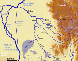
The Pibor River is a river in eastern South Sudan, which defines part of South Sudan's border with Ethiopia. From its source near Pibor Post it flows north for about 320 kilometres (200 mi), joining the Baro River to form the Sobat River, which is a tributary of the White Nile.
Boma National Park is a protected area in eastern South Sudan near the Ethiopian border. It was established in 1977 and covers 22,800 km2 (8,800 sq mi) of grasslands and floodplains.
The Kongkong River, also spelled Kong Kong, is a stream in the South Sudanese state of Jonglei, west of Boma National Park near the Ethiopian border. At the village of Bongak it joins the Abara River to form the Agwei or Agvey River, a tributary of the Pibor River. The Kongkong is within the drainage basin of the White Nile.
The Agwei River or the River Agwei, also spelled Agvey, is a tributary of the Pibor River that flows through eastern South Sudan. Its own tributaries include the Abara and Kongkong rivers. The river is a wadi, or ravine, that may run dry during the dry season but quickly becomes a watercourse due to heavy rainfall during the wet season.

Water supply in Southern Sudan is faced with numerous challenges. Although the White Nile runs through the country, water is scarce during the dry season in areas that are not located on the river.
Sudan is a country that is half desert and much of the population suffers from a shortage of clean drinking water as well as a reliable source of water for agriculture. With the Nile river in the east of the country, parts of Sudan have substantial water resources, but those in the west have to rely on wadis, seasonal wells which often dry up. These imbalances in water availability are a source of hardship, as well as a source of conflict. While storage facilities are limited, many local communities have constructed makeshift dams and reservoirs, weirs, which help in stabilizing farming communities. Farmers also utilize hafirs to store rain water which falls in the rainy season, but groundwater remains a vital source of water for over 80% of Sudanese people. For decades, political instability has led to terrible conditions and thwarted many projects and relief efforts, but aid is making its way through. Several water infrastructure projects have been enacted in recent years, with both domestic and international sources of funding. Funding from the UN has provided 9,550 local farmers with better access to water and fertile soils. A project which also plans to replant forest cover in the wadi to reverse desertification.

Yei River County is an administrative area in Central Equatoria with a large population of people who settled in that particular county.
