
The Nile is a major north-flowing river in northeastern Africa, and is the longest river in Africa and the disputed longest river in the world, as the Brazilian government says that the Amazon River is longer than the Nile. The Nile is about 6,650 km (4,130 mi) long and its drainage basin covers eleven countries: Tanzania, Uganda, Rwanda, Burundi, the Democratic Republic of the Congo, Kenya, Ethiopia, Eritrea, South Sudan, Republic of the Sudan, and Egypt. In particular, the Nile is the primary water source of Egypt and Sudan.

The White Nile is a river in Africa, one of the two main tributaries of the Nile; the other is the Blue Nile. The name comes from colouring due to clay carried in the water.

The Sudd is a vast swamp in South Sudan, formed by the White Nile's Baḥr al-Jabal section. The Arabic word sudd is derived from sadd (سد), meaning "barrier" or "obstruction". The term "the sudd" has come to refer to any large solid floating vegetation island or mat. The area which the swamp covers is one of the world's largest wetlands and the largest freshwater wetland in the Nile basin.

Below is a list of the 18 states of Sudan, organized by their original provinces during the period of Anglo-Egyptian Sudan. Arabic language versions are, as appropriate, in parentheses. Prior to 9 July 2011, the Republic of Sudan was composed of 25 states. The ten southern states now form part of the independent country of South Sudan. Two additional states were created in 2012 within the Darfur region, and one in 2013 in Kordofan, bringing the total to 18.

Western Bahr el Ghazal is a state in South Sudan. It has an area of 93,900 km2 (36,255 sq mi) and is the least populous state in South Sudan, according to the controversial Sudanese census conducted in 2008. It is part of the Bahr el Ghazal region. Its capital is Wau. The state shared international borders with Sudan to the north and the Central African Republic to the west. The portion now occupied by Raga County is the southern part of the historical region known as "Dar Fertit".

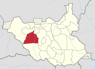
Northern Bahr el Ghazal is a state in South Sudan. It has an area of 30,543 km² and is part of the Bahr el Ghazal region. It borders East Darfur in Sudan to the north, Western Bahr el Ghazal to the west and south, and Warrap and the disputed region of Abyei to the east. Aweil is the capital of the state.

The Bahr el Ghazal is a historical region of northwestern South Sudan. Its name came from the river Bahr el Ghazal. The name translates as "sea of gazelles" from Arabic.

Wau is a city in northwestern South Sudan, on the western bank of the Jur River, that serves as capital for Western Bahr el Ghazal. It lies approximately 650 kilometres (400 mi) northwest of the capital Juba. A culturally, ethnically and linguistically diverse urban center and trading hub, Wau is also the former headquarters of Western Bahr el Ghazal.

Bahr al-Arab (also called the Kiir River) is a river which flows approximately 800 kilometres (500 mi) through the southwest of Sudan and marks part of its international border with South Sudan. It is part of the Nile river system, being a tributary of Bahr el Ghazal, which is a tributary of the White Nile.

The Luo River or Jur River is a river in western South Sudan, flowing through the Bahr el Ghazal and Equatoria regions. About 485 kilometres (301 mi) long, it flows north and northeast, joining the Bahr el Ghazal River on the western side of the Sudd wetlands. The Jur River is part of the Nile basin, as the Bahr al-Ghazal flows into the White Nile.

The Bahr el Ghazal is a river in South Sudan. The name translates as "sea of gazelles" from Arabic. The South Sudanese region of Bahr el Ghazal takes its name from the river.

South Sudan, officially known as the Republic of South Sudan, is a landlocked country in East-Central-Africa. It is bordered to the east by Ethiopia, to the north by Sudan, to the west by the Central African Republic, to the south-west by Democratic Republic of the Congo, to the south by Uganda and to the south east by Kenya.
The Lol River, also spelled Loll, is a stream in northern South Sudan that feeds the Bahr al-Arab, known locally as the Kiir River. It meets the larger river in Warrap state, south of the disputed Abyei Area and roughly 100 kilometers west of Bentiu.
Adda is a tributary of the Po in North Italy.
Wau State was a state in South Sudan that existed between 2 October 2015 and 22 February 2020. It was located in the Bahr el Ghazal region, and was part of the former state of Western Bahr el Ghazal. Wau State bordered Aweil State, Gbudwe State, Gogrial State, Lol State, and Tonj State.

Tonj State was a state in South Sudan that existed between 2 October 2015 and 22 February 2020.. It was located in the Bahr el Ghazal region and it bordered Wau to the west, Gbudwe to the southwest, Gogrial to the northwest, Northern Liech to the northeast, Gok and Southern Liech to the east, and Western Lakes to the south and east.
Bahr el-Ghazal may refer to two distinct places, both named after ephemeral or dry rivers.
