The Omo River in southern Ethiopia is the largest Ethiopian river outside the Nile Basin. Its course is entirely contained within the boundaries of Ethiopia, and it empties into Lake Turkana on the border with Kenya. The river is the principal stream of an endorheic drainage basin, the Turkana Basin.
The Usno River is a tributary of the Omo River in Ethiopia. Formed by the confluence of the Magi and the Neri rivers, it flows south past the Nyalibong Hills before entering the Omo. Almost all of the Usno's course is inside the boundaries of the Mago National Park.
The Germama River, is a tributary of the Awash River in Ethiopia. The name Germama comes from the Amharic word which means "frolicking", "boisterous", or "frisky".

The Pibor River is a river in eastern South Sudan, which defines part of South Sudan's border with Ethiopia. From its source near Pibor Post it flows north for about 320 kilometres (200 mi), joining the Baro River to form the Sobat River, which is a tributary of the White Nile.
The Akobo River is a river on the border between South Sudan and Ethiopia. From its source in the Ethiopian Highlands near Mizan Teferi it flows west for 434 kilometres (270 mi) to join the Pibor River. The Pibor flows into the Sobat River, which in turn empties into the White Nile.
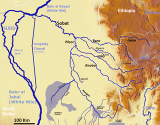
The Gilo River is a river in the Gambela Region of southwestern Ethiopia. A variety of names also knows it: the Gimira of Dizu call it the "Mene", while the Gemira of Chako call it "Owis", and Amhara and Oromo settlers in the early 20th century knew it by a third name, "Bako". From its source in the Ethiopian Highlands near Mizan Teferi it flows to the west, through Lake Tata to join the Pibor River on Ethiopia's border with Sudan. The combined waters then join the Sobat River and the White Nile.
Katar River is a river of central Ethiopia. It arises from the glaciated slopes of Mount Kaka and Mount Badda in the Arsi Zone. The Katar's tributaries include the Gonde. The gradient of the river is generally steep, and areas suitable for irrigation are few in number and very limited in extent. With a watershed of 3,398 km2, the Katar drains into Lake Ziway. It is the largest river draining into Lake Ziway.
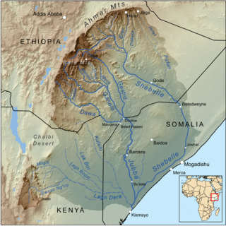
The Ganale Doria River is a perennial river in southeastern Ethiopia. Rising in the mountains east of Aleta Wendo, the Ganale flows south and east to join with the Dawa at the border with Somalia to become the Jubba. The river's tributaries include the Welmel, Weyib, and Mena. The Del Verme Falls is a notable feature of its middle course.

The Mille River is a river of Ethiopia and a tributary of the Awash. It drains parts of the Semien (North) Wollo and Debub (South) Wollo Zones of the Amhara Region, as well as Administrative Zone 4 of the Afar Region. The explorer L.M. Nesbitt, who travelled through the area in 1928, was impressed by its size, and described the Mille as "probably the only real river which joins the Awash". The Ala River (A'ura) and Golima River (Golina) are small tributaries of the Mille.
Borkana River is a river of central Ethiopia. A left tributary of the Awash. Johann Ludwig Krapf records that it was called "Tshaffa" by the local Oromo people.
The Erer is a perennial river of eastern Ethiopia. It rises near the city of Harar, in Harari Region, and flows in a primarily southern direction to its confluence with the Shabelle.
Fafen River is a river of eastern Ethiopia. Rising to the east of Harar, in Harari Region, it cuts through a series of wide, flat shelves of sedimentary rocks made of sandstone, limestone, and gypsum as it descends in a south-eastern direction towards the Shebelle River. The Fafen only joins the Shebelle river during times of heavy rainfall.
Galetti River is a river in eastern Ethiopia. It is a tributary of the Ramis River, which is in turn a tributary of the 2,714 km long Shebelle River.
Gololcha River is a river of eastern Ethiopia. It flows into the Awash River.
The Kabenna is a river of central Ethiopia. It is a tributary of the Awash River to its west, having its source to the southwest of Ankobar. G.W.B. Huntingford speculates that it may be the same river as the Kuba, which is mentioned in the Futuh al-habaša, the narrative of Imam Ahmad Gragn's conquest of the Ethiopian Empire.
The Keleta is a river in Ethiopia. It arises near the Chilalo mountains and flows into the Awash River.
The Meki is a river in central Oromia, Ethiopia. It empties into Hora-Dambal.

Weyib River is a river of eastern Ethiopia. It rises in the Bale Mountains east of Goba in the Oromia Region, flowing east to pass through the Sof Omar Caves, then to the southeast until it joins the Ganale Dorya River in the Somali Region.
The Welmel is a river of eastern Ethiopia. It is a tributary of the Ganale Dorya River, which in turn is a tributary of the Jubba River. The headwaters of the Welmel are in the Bale Mountains of the Ethiopian Highlands, and it flow southeast for 311 km (193 mi) to its mouth.
The Belessa River is a tributary of the Mereb River in Ethiopia. Part of its course forms a section of border between Ethiopia and Eritrea.