
The Central African Republic is a landlocked nation within the interior of the African continent. It is bordered by Cameroon, Chad, Sudan, South Sudan, the Democratic Republic of the Congo and the Republic of the Congo. Much of the country consists of flat, or rolling plateau savanna, about 1,640 feet (500 m) above sea level. In the northeast are the Fertit Hills, and there are scattered hills in the southwestern part of the country. To the northwest is the Karre Mountains, a granite plateau with an altitude of 3,750 feet (1,143 m).

The Nile is a major north-flowing river in northeastern Africa. It flows into the Mediterranean Sea. The longest river in Africa, it has historically been considered the longest river in the world, though this has been contested by research suggesting that the Amazon River is slightly longer. The Nile is amongst the smallest of the major world rivers by measure of cubic metres flowing annually. About 6,650 km (4,130 mi) long, its drainage basin covers eleven countries: Tanzania, Uganda, Rwanda, Burundi, the Democratic Republic of the Congo, Kenya, Ethiopia, Eritrea, South Sudan, Republic of the Sudan, and Egypt. In particular, the Nile is the primary water source of Egypt, Sudan and South Sudan. Additionally, the Nile is an important economic river, supporting agriculture and fishing.

Sudan, officially the Republic of the Sudan and simply known as North Sudan, is a country in Northeast Africa. It borders the countries of Central African Republic, Chad, Egypt, Eritrea, Ethiopia, Libya, South Sudan, and the Red Sea. It has a population of 44.91 million people as of 2021 and occupies 1,886,068 square kilometres, making it Africa's third-largest country by area, and the third-largest by area in the Arab League. It was the largest country by area in Africa and the Arab League until the secession of South Sudan in 2011, since which both titles have been held by Algeria. Its capital is Khartoum and its most populated city is Omdurman.

Sudan is located in Northeast Africa. It is bordered by Egypt to the north, the Red Sea to the northeast, Eritrea and Ethiopia to the east, South Sudan to the south, the Central African Republic to the southwest, Chad to the west and Libya to the northwest. Sudan is the third largest country in Africa, after Algeria and the Democratic Republic of the Congo. It had been the largest country on the continent until the 2011 independence of South Sudan.

Transport in Sudan during the early 1990s included an extensive railroad system that served the more important populated areas except in the far south, a meager road network, a natural inland waterway—the Nile River and its tributaries—and a national airline that provided both international and domestic service. Complementing this infrastructure was Port Sudan, a major deep-water port on the Red Sea, and a small but modern national merchant marine. Additionally, a pipeline transporting petroleum products extended from the port to Khartoum.

The White Nile is a river in Africa, one of the two main tributaries of the Nile, the other being the Blue Nile. The name comes from colouring due to clay carried in the water.

Sudan is the geographic region to the south of the Sahara, stretching from Western to eastern Central Africa. The name derives from the Arabic bilād as-sūdān, or "the lands of the Blacks", referring to West Africa and northern Central Africa.

Below is a list of the 18 states of Sudan, organized by their original provinces during the period of Anglo-Egyptian Sudan. Arabic language versions are, as appropriate, in parentheses. Prior to 9 July 2011, the Republic of Sudan was composed of 25 states. The ten southern states now form part of the independent country of South Sudan. Two additional states were created in 2012 within the Darfur region, and one in 2013 in Kordofan, bringing the total to 18.
The Dinka people are a Nilotic ethnic group native to South Sudan with a sizable diaspora population abroad. The Dinka mostly live along the Nile, from Bor to Renk, in the region of Bahr el Ghazal, Upper Nile and the Abyei Area of the Ngok Dinka in South Sudan.

Juba is the capital and largest city of South Sudan. The city is situated on the White Nile and also serves as the capital of the Central Equatoria State. It is the world's newest capital city to be elevated as such, and had a population of 525,953 in 2017. It has an area of 52 km2 (20 sq mi), with the metropolitan area covering 336 km2 (130 sq mi).

Bor is a historic city in South Sudan’s central region, being the epicenter of national liberation revolution with multiple landmarks that tells the story. In Malual-Chaat barrack, statues of liberators and destroyed weapons are conserved and exhibited as historical heritage site. It has also served as the headquarters of Jonglei state. The city is situated on the east side of the White Nile at the southern extent of the sudd, South Sudan's vast central wetlands.

Malakal is a city in South Sudan. It is the capital of Upper Nile State, South Sudan, along the White Nile River. It also serves as the headquarters of Malakal county.
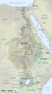
The Nile Basin is the part of Africa drained by the Nile River and its tributaries.

South Sudan, officially known as the Republic of South Sudan, is a landlocked country in east/central Africa. It is bordered by Ethiopia, Sudan, Central African Republic, Democratic Republic of the Congo, Uganda and Kenya. Its population was estimated as 12,778,250 in 2019. Juba is the capital and largest city. The nation is sometimes informally referred to as the Nilotic Republic.
The Kinyeti River flows northward from the Imatong Mountains in the Imatong State of South Sudan, eventually dispersing into the Badigeru swamp.
Water supply in Southern Sudan is faced with numerous challenges. Although the White Nile runs through the country, water is scarce during the dry season in areas that are not located on the river.

The Sudans is a region in Northeast Africa comprising the sovereign countries of Sudan and South Sudan. Until 2011, the region was united under a state known as the Republic of the Sudan.

