Torit County

Last updated
Torit county
South Sudan adm location map.svg
Red pog.svg
Torit county
Location in South Sudan
Coordinates: 4°25′N32°34′E / 4.417°N 32.567°E / 4.417; 32.567
Country Flag of South Sudan.svg South Sudan
State Eastern Equatoria
Headquarters Torit
Government
  County CommissionerFermo Peter Isara [1]
Area
  Total2,253 sq mi (5,835 km2)
Population
 (2017 estimate [2] )
  Total153,314
  Density68/sq mi (26/km2)
Time zone UTC+2 (CAT)
Eastern Equatoria State - Torit County in the Southwest Eastern Equatoria map.svg
Eastern Equatoria State – Torit County in the Southwest

Torit County is an administrative region in Eastern Equatoria of South Sudan, [3] with headquarters in the town of Torit, which is also the state capital.

Contents

Location

Torit County is located in Torit State, in southern South Sudan, close to the border with Kenya and Uganda . Torit is one of the tens states of South Sudan known as Eastern Equatoria state. Torit county is bordered by his neighbors county ,Lopa County to the north, Kapoeta county to the east, Ikowot county to the east south, Magwi County to the west and Juba County in the extreme northwest. (See map to the right).

The town of Torit, where the county headquarters are located, lies approximately 150 kilometres (93 mi), by road, east of Juba, the capital and largest city in South Sudan. [4] The coordinates of Torit County are: 4° 30' 0.00"N, 32° 30' 0.00"E (Latitude: 4.5000; Longitude: 32.5000).

Overview

Torit County was earlier split into 8 payams. The payams that constitute Torit County include the following: [5]

  1. Bur Payam
  2. Ifwotu Payam
  3. Kudo Payam
  4. Hiyala Payam
  5. Himodonge Payam
  6. Imurok Payam
  7. Nyong Payam
  8. Iyire Payam

The town of Torit is the headquarters of Torit County, one of the eleven counties which make up Torit State. Torit is also the capital of Torit State, one of the twenty-eight states which constitute the Republic of South Sudan. The Imatong Mountains lie partly in the southern part of Torit County. In April 2016, the county was divided into 3 counties, with 2 new counties of Torit East and Torit West being carved out of the county. [6]

History

Torit County was formed in 1934 by the merging of the districts of Teretenya and Opari. Opari was the district administrative headquarters for the regions inhabited by the Lotuko (Otuho), Madi and Acholi ethnic groups. Torit county was adversely affected by both the Second Sudanese Civil War and by the activities of the Lord's Resistance Army. As late as 2006, a significant portion of its population was still internally displaced within South Sudan.

Population

The 2008 Sudanese census estimated the population of Torit County at approximately 99,740 [7] Although these results were disputed by the South Sudanese authorities, they are the only recent figures available and form a basis on which newer studies can be based.

In April 2016, the state was divided into 3 counties with 2 new counties called Torit East and Torit West being carved out of it. [6]

See also

Related Research Articles

<span class="mw-page-title-main">Eastern Equatoria</span> State of South Sudan

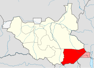
Eastern Equatoria is a state in South Sudan. It has an area of 73,472 km². The capital City is Torit. On October 1, 1972, the state was divided into Imatong and Namorunyang states and was re-established by a peace agreement signed on 22 February 2020.

<span class="mw-page-title-main">Torit</span> City in South Sudan

Torit is a city of Eastern Equatoria State in South Sudan.

Kaya is a city in Central Equatoria, South Sudan.

<span class="mw-page-title-main">Magwi County</span> County in Eastern Equatoria, South Sudan

Magwi County, also Magwe County, is a county in Eastern Equatoria, South Sudan.

<span class="mw-page-title-main">Kapoeta</span> Town in Eastern Equatoria State, South Sudan

Kapoeta is a town in South Sudan. It is located in Kapoeta South County, in Eastern Equatoria State, in southeastern South Sudan.

The Koss River is a river that flows in a north of northwest direction through the erstwhile Eastern Equatoria state of South Sudan, fed by streams from the Imatong Mountains to the west.

Ikwoto County was an administrative area in the Eastern Equatoria state of South Sudan with headquarters in the town of Ikwoto. The people, who live in the former county's area by subsistence agriculture and cattle herding, are poverty-stricken. Years of civil war have made violence commonplace: most people have experienced the murder of a close family member. In 2009, AK-47 rifles were used in 42 per cent of killings.

<span class="mw-page-title-main">Magwi</span> Town in Eastern Equatoria State, South Sudan

Magwi is a town in South Sudan. It is the capital, business center and home to Acoli tribe of South Sudan.

Lafon is a county in Eastern Equatoria State of South Sudan. The largest town is Lafon.

<span class="mw-page-title-main">Greater Kapoeta</span>

Greater Kapoeta is the name given to the eastern half of the erstwhile Eastern Equatoria State in South Sudan, at one time an administrative region with headquarters in the town of Kapoeta. Greater Kapoeta was divided between Kapoeta County and Budi County, named after the Buya and Didinga (BU-DI) people. Kapoeta County was later split into Kapoeta North, South and East counties.

Louis Lobong Lojore is a South Sudanese Politician and a military governor in the rank of brigadier general in the South Sudan People's Defence Forces (SSPDF) and the current governor of Eastern Equatoria State in South Sudan. He was the governor of Eastern Equatoria state from 2010 to 2015, governor of Kapoeta State from 2015 to 2020, and has been the governor of the recreated Eastern Equatoria state since 29 June 2020. Lobong is the longest serving governor in South Sudan.

<span class="mw-page-title-main">Kapoeta South County</span> County in Eastern Equatoria State, South Sudan

Kapoeta South County is an administrative region in Eastern Equatoria State. The county logo is a ram with horns and slightly bent tail. The county includes the Kapoeta Town, Machi and Namorunyang Payams.

<span class="mw-page-title-main">Kapoeta East County</span> County in Eastern Equatoria, South Sudan

Kapoeta East County is an administrative region of Eastern Equatoria state in South Sudan, bordered by Kenya to the south, Ethiopia to the east and Jonglei state to the west. It is part of the Greater Kapoeta region of the state. The largest ethnic group is the Toposa people. The principal town is Narus. The county includes the disputed Ilemi triangle, controlled by Kenya. The emblem of the county is a horned bull, with big humps and a large tail.

George Echom Ekeno is a politician who was deputy governor of Eastern Equatoria state in South Sudan, and was later appointed state minister for Environment, Wildlife Conservation & Tourism.

<span class="mw-page-title-main">Juba County</span> County in Central Equatoria, South Sudan

Juba County is an administrative area in Central Equatoria state, South Sudan. It was the largest county in Central Equatoria and one of the largest in the entire region of Equatoria. Its county seat was Juba, the state capital of Central Equatoria and the national capital of the Republic of South Sudan.

Lolim is a community located in Eastern Equatoria state of South Sudan. It is on the road from Kapoeta to Narus. Lolim lies just north of the Loyuro River, which has a pool called Lolimi. The community is mainly made up of Toposa people.

<span class="mw-page-title-main">Kapoeta North County</span> County in Eastern Equatoria, South Sudan

Kapoeta North County is an administrative division of Eastern Equatoria. The principal settlement is Riwoto and the largest ethnic group are the Toposa people. The county emblem is an elephant.

<span class="mw-page-title-main">Imatong State</span> State of South Sudan from 2015 to 2020

Imatong State was a state in South Sudan that existed between 2 October 2015 and 22 February 2020. It was located in the Equatoria region and it bordered Yei River to the southwest, Jubek to the west, Terekeka and Jonglei to the northwest, Boma to the northeast, Namorunyang to the east, and Uganda to the south.

<span class="mw-page-title-main">Kapoeta State</span> State of South Sudan from 2015 to 2020

Kapoeta State was a state in South Sudan that existed between 2 October 2015 and 22 February 2020. It was located in the Equatoria region and it bordered Imatong to the west, Boma to the north, Ethiopia to the east, and Kenya and Uganda to the south.

Kuron is a boma in Kauto Payam, Kapoeta East County, Namorunyang State, South Sudan.

References

  1. Peter Lokale Nakimangole (14 August 2016). "New Public Leaders' Appointments In Imatong Counties". Gurtong. Retrieved 20 August 2016.
  2. "South Sudan: States and counties". www.citypopulation.de. Retrieved 2024-02-14.
  3. "Torit: Speaker And Deputy Elected, Commissioners, Administrators Sworn In". Gurtong. 4 March 2016. Retrieved 14 August 2016.
  4. Estimated Road Distance Between Juba And Torit With Maap
  5. Partial Listing of the Payams of Torit County Archived 2012-03-26 at the Wayback Machine
  6. 1 2 Nakimangole, Peter Lokale (22 April 2016). "Additional Counties In Torit And Kapoeta States Established". Gurtong. Retrieved 14 August 2016.
  7. 2008 South Sudanese Population By County

4°30′N32°30′E / 4.500°N 32.500°E / 4.500; 32.500