
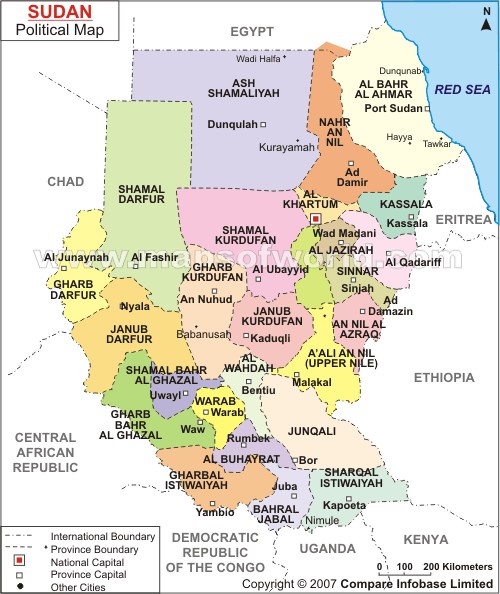
Central Equatoria is a state in South Sudan. With an area of 43,033 square kilometres (16,615 sq mi), it is the smallest of the original South Sudanese states. Its previous name was Bahr al-Jabal, named after a tributary of the White Nile that flows through the state. It was renamed Central Equatoria in the first Interim Legislative Assembly on 1 April 2005 under the government of Southern Sudan. Central Equatoria seceded from Sudan as part of the Republic of South Sudan on 9 July 2011. The state's capital, Juba, is also the national capital of South Sudan. On October 2, 2015, the state was split into three states: Jubek, Terekeka, and Yei River. The state of Central Equatoria was re-established by a peace agreement signed on 22 February 2020.
Eastern Equatoria is a state in South Sudan. It has an area of 73,472 km2. The capital City is Torit. On October 1, 1972, the state was divided into Imatong and Namorunyang states and was re-established by a peace agreement signed on 22 February 2020.

Juba is the capital and largest city of South Sudan. The city is situated on the White Nile and also serves as the capital of the Central Equatoria State. It is the most recently declared national capital and had a population of 525,953 in 2017. It has an area of 52 km2 (20 sq mi), with the metropolitan area covering 336 km2 (130 sq mi).
Kaya is a city in Central Equatoria, South Sudan.

The Mà'dí are a Central Sudanic speaking people that live in Magwi County in Eastern Equatoria, South Sudan and the districts of Adjumani and Moyo in Uganda. From south to north, the area runs from Nimule, at the South Sudan-Uganda border, to Nyolo River where the Ma’di mingle with the Acholi, the Bari, and the Lolubo. From the east to west, it runs from Parajok/Magwi to Uganda across the River Nile.
Yambio is a city in South Sudan.

The Roman Catholic Diocese of Torit is a diocese located in Torit in the ecclesiastical province of Juba in South Sudan.
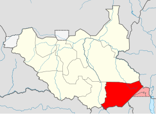
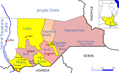
Nimule is a city in the southern part of South Sudan in Magwi County, Eastern Equatoria. It lies approximately 197 kilometres (122 mi), by road, southeast of Juba, the capital of South Sudan and largest city in the country. The town also lies approximately 120 kilometres (75 mi), by road, north of Gulu, Uganda, the nearest large city.
Atiak is a town in the Northern Region of Uganda on the Gulu-Nimule Road, the primary trade route between Uganda and South Sudan.

Lainya is a county in Central Equatoria State, South Sudan. Emmanuel Khamis Richard is the current commissioner of Lainya County.
Nimule Airport is a small civilian and military airport serving the town of Nimule and surrounding communities, in South Sudan.
Tumbura, sometimes spelled Tambora or Tambura, is a town in South Sudan.
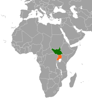
South Sudan and Uganda are neighboring states with strong cultural economic and political ties. The South Sudan and the neighbouring state of Uganda enjoy relatively strong cultural, political, and economic ties. As South Sudan neared independence, both states begun to take advantage of increased opportunities for trade, development and educational exchanges. The rebel group Lord's Resistance Army (LRA), however, continues to operate in the border areas between South Sudan, the Democratic Republic of Congo and Uganda.

Torit County is an administrative region in Eastern Equatoria of South Sudan, with headquarters in the town of Torit, which is also the state capital.
Ikotos County is an administrative area in the Eastern Equatoria state of South Sudan with headquarters in the town of Ikotos. The people, who live in the county's area by subsistence agriculture and cattle herding, are poverty-stricken. Years of civil war have made violence commonplace: most people have experienced the murder of a close family member. In 2009, AK-47 rifles were used in 42 per cent of killings.
Tirangore is a village in the Hiyala Payam of Torit county in the Eastern Equatoria State of South Sudan. It lies to the northeast of Torit.

Magwi is a town in South Sudan. It is the capital, business center and home to the Acholi tribe of South Sudan.
Pajok is a community in Eastern Equatoria, a state of South Sudan. It is in the southern part of Magwi County, 39 kilometres (24 mi) south of Magwi, near the border with Uganda.
The Juba–Nimule Road is a road in South Sudan connecting the capital city of Juba in the Eastern Equatoria and the town of Nimule in Magwi County.
Kajo Keji County is an administrative area in Central Equatoria, South Sudan.
