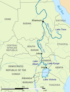
The Nile is a major north-flowing river in northeastern Africa, and is the longest river in Africa and in the world, though some sources cite the Amazon River as the longest. The Nile, which is about 6,650 km (4,130 mi) long, is an "international" river as its drainage basin covers eleven countries, namely, Tanzania, Uganda, Rwanda, Burundi, the Democratic Republic of the Congo, Kenya, Ethiopia, Eritrea, South Sudan, Republic of the Sudan and Egypt. In particular, the Nile is the primary water source of Egypt and Sudan.

Agusan River is a river in the Philippines, located in the north-eastern part of Mindanao island, draining majority of the Caraga region and some parts of Compostela Valley province. It is the country's third largest river basin with a total drainage area of 11,937 square kilometres (4,609 sq mi) and an estimated length of 390 kilometres (240 mi) from its origin. The headwaters of the river are found in the mountains of Compostela Valley, near its border with Davao Oriental and east of Tagum City. It flows through the wide Agusan River valley which measures 177 kilometers (110 mi) from south to north and varies from 32–48 kilometers in width. It finally drains into the Butuan Bay at its mouth in Butuan City.

The Gezira Scheme is one of the largest irrigation projects in the world. It is centered on the Sudanese state of Al Jazirah, just southeast of the confluence of the Blue and White Nile rivers at the city of Khartoum. The Gezira Scheme was begun by the British while the area was governed as part of Anglo-Egyptian Sudan. Water from the Blue Nile is distributed through canals and ditches to tenant farms lying between the Blue and White Nile rivers.

Mount Kinyeti is the highest peak in South Sudan. It is located in the Imatong Mountains in Ikwoto County of Imatong State state, near the Ugandan border. It was earlier located in Eastern Equatoria before the reorganisation of states. Kinyeti has an elevation of 3,187 metres (10,456 ft) above sea level. The group of high mountains that contain Kinyeti, extending to the border with Uganda, are sometimes called the Lomariti or Lolobai mountains.

Magwi County, also Magwe County, is a county in South Sudan.

The Bahr el Zeraf, or Zeraf River in the English language, is an arm of the White Nile in the Sudd region of South Sudan. It is completely contained within the South Sudanese state of Jonglei. Its name is Arabic for "Giraffe River".

The Nyabarongo is a major river in Rwanda, part of the upper headwaters of the Nile. At 297 km, it is the longest river entirely in Rwanda. The river begins its course at the confluence of the rivers Mbirurume and Mwogo in the South West of the country. These two rivers themselves begin in Nyungwe Forest, and are considered by some to be the most distant source of the Nile. From its start, Nyabarongo flows northward for 85 km, and forms the border between the Western and Southern Provinces. At the confluence with the river Mukungwa, the river changes course and flows eastward for 12 km, then to a more South Eastern course for the last 200 km. For the longest stretch of this course, the river serves as the boundary between the Northern and Southern Provinces, then between the City of Kigali and the Southern Province, and lastly between the City of Kigali and the Eastern Province. The river then before enters the Eastern Province and ends its course close to the border with Burundi. The Nyabarongo River empties both in Lake Rweru and Akagera river in a small but complicated Delta. The Akagera river outflows from Lake Rweru, a mere 1 km from the Nyabarongo delta. Almost all the branches of the Nyabarongo delta empty in the lake, however, one branch of the delta empties directly in the just formed Akagera river. The Akagera River eventually flows into Lake Victoria and forms the Nile.

Torit County is an administrative region in Imatong State of South Sudan, with headquarters in the town of Torit, which is also the state capital.
The Koss River is a river that flows in a north of northwest direction through the erstwhile Eastern Equatoria state of South Sudan, fed by streams from the Imatong Mountains to the west.

Ikotos County was an administrative area in the Eastern Equatoria state of South Sudan with headquarters in the town of Ikotos. The people, who live in the former county's area by subsistence agriculture and cattle herding, are poverty-stricken. Years of civil war have made violence commonplace: most people have experienced the murder of a close family member. In 2009, AK-47 rifles were used in 42 per cent of killings.

Tirangore is a village in the Hiyala Payam of Torit county in the Eastern Equatoria State of South Sudan. It lies to the northeast of Torit.

The geography of South Sudan describes the physical features of South Sudan, a country in East Africa. South Sudan is a landlocked country and borders - clockwise - Sudan from the north, Ethiopia from the east, Kenya, Uganda and the Democratic Republic of the Congo from the south and the Central African Republic from the west.
The Machar Marshes are a large area of wetlands in the state of Upper Nile, South Sudan. Estimates of their size vary. A 1950 study put the area of swamp at 6,500 km2. A 1980 study put the area of permanent swamp at 8,700 km2., 60% of which was grass and forest.
The Badigeru swamp swamp lies in South Sudan, in the Central Equatoria and Eastern Equatoria states between Terekeka and Lafon.

The Congo-Nile Divide is the continental divide that separates the drainage basins of the Nile and Congo rivers. It is about 2,000 kilometres (1,200 mi) long.

The Ironstone Plateau is a region in the south and west of South Sudan.
The Sudans is a region in Africa comprising the countries of Sudan and South Sudan.


