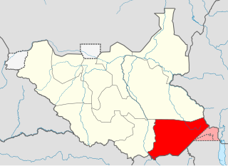
Eastern Equatoria is a state in South Sudan. It has an area of 73,472 km². The capital is Torit. On October 1, 1972, the state was divided into Imatong and Namorunyang states and was re-established by a peace agreement signed on 22 February 2020.
The Didinga (diDinga) are a Surmic ethnic group that occupy the Didinga Mountains region in Budi County, Eastern Equatoria State in South Sudan. They live in the valleys, on the plateaus and slopes, and on the adjacent plains of the region. Their neighbors include the Toposa, the Boya, Ketebo, Logir, Teuth and Dongotona peoples - groups with whom the Didinga have had frequent conflicts due to economic pressures.
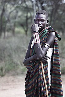
The Toposa are an ethnic group in South Sudan, living in the Greater Kapoeta region of the erstwhile Eastern Equatoria state. They have traditionally lived by herding cattle, sheep and goats, and in the past were involved in the ivory trade. They have a tradition of constant low-level warfare, usually cattle raids, against their neighbors.

Kapoeta is a town in South Sudan. It is located in Kapoeta South County, in Eastern Equatoria State, in southeastern South Sudan.
The Boya are a Surmic ethnic group numbering 20,000 to 25,000 people living in Budi County, part of the Greater Kapoeta region of the South Sudanese state of the erstwhile Eastern Equatoria.

Chukudum is a village in Budi County of the Eastern Equatoria state of South Sudan.
Budi County is an administrative area of Eastern Equatoria state in South Sudan, with headquarters in Chukudum.
Peter Lorot is a former officer who served with the Sudan People's Liberation Army (SPLA) during the Second Sudanese Civil War (1983-2005). He broke away from the SPLA in 1999 with a Didinga force based on Chukudum, in Budi County of Eastern Equatoria State in South Sudan. In the resulting conflict many people were displaced. As of April 2011 Lorot's forces were still not reconciled with the de facto SPLM government.

Greater Kapoeta is the name given to the eastern half of the erstwhile Eastern Equatoria State in South Sudan, at one time an administrative region with headquarters in the town of Kapoeta. Greater Kapoeta was divided between Kapoeta County and Budi County, named after the Buya and Didinga (BU-DI) people. Kapoeta County was later split into Kapoeta North, South and East counties.
Louis Lobong Lojore is a former brigadier general in the Sudan People's Liberation Army (SPLA) and the current governor of Eastern Equatoria State in South Sudan. He was the governor of Eastern Equatoria state from 2010-2015, governor of Kapoeta State from 2015-2020, and has been the governor of the recreated Eastern Equatoria state since 29 June 2020. Lobong is the longest serving governor in South Sudan.

Namorunyang is a village and Payam of Kapoeta South County in Namorunyang State, South Sudan.
Narus is a community in the Eastern Equatoria of South Sudan. It is the headquarters of Kapoeta East County.
The Narus River originates in the east of the Didinga Hills in the erstwhile Eastern Equatoria State, South Sudan. It flows eastward and discharges into the swampy area northeast of Narus. The river floods during the rainy season, but ceases to flow at other times. Gold has reportedly been panned in the river bed, probably washed down from the Didinga Hills. During the rainy season, the river virtually cuts the town of Narus in two as the riverbed fills and sometimes floods. The small market area is also cut into two halves, one on each side of the riverbed.
Nadapal is a community in the south west of Kapoeta East County, South Sudan near the border with the Rift Valley province of Kenya. The Nadapal belt is an area stretching 25 kilometres (16 mi) southward from the border with South Sudan to Lokichogio in Kenya.
The Singaita River is a river in Eastern Equatoria state of South Sudan that flows through the town of Kapoeta.
The Loyuro River is a stream in Eastern Equatoria State of South Sudan. The river originates in the east of Didinga Hills, flowing eastward into Greater Kapoeta and discharging into the swampy area northeast of Narus. The river floods during the rainy season, but ceases to flow at other times. The Toposa people have a ritual center at Loyuro River. Lolimi is a permanent water hole on the river, on the road between Narus and Kapoeta.
Kapoeta East County is an administrative region of Eastern Equatoria state in South Sudan, bordered by Kenya to the south, Ethiopia to the east and Jonglei state to the west. It is part of the Greater Kapoeta region of the state. The largest ethnic group is the Toposa people. The principal town is Narus. The county includes the disputed Ilemi triangle, controlled by Kenya. The emblem of the county is a horned bull, with big humps and a large tail.
Loyoro is a community in Eastern Equatoria state of South Sudan, about 50 kilometres (31 mi) as the crow flies to the north east of Narus. It lies on the Loyoro River. Loyoro is part of the Narus parish of the Catholic Diocese of Torit.
Kauto Payam
Kapoeta State was a state in South Sudan that existed between 2 October 2015 and 22 February 2020. It was located in the Equatoria region and it bordered Imatong to the west, Boma to the north, Ethiopia to the east, and Kenya and Uganda to the south.

