Kapoeta South County

Last updated
Kapoeta South County
South Sudan adm location map.svg
Red pog.svg
Kapoeta South County
Location in South Sudan
Coordinates: 04°46′30″N33°35′24″E / 4.77500°N 33.59000°E / 4.77500; 33.59000
Country Flag of South Sudan.svg South Sudan
State Eastern Equatoria State
Headquarters Kapoeta
Government
  County CommissionerMarko Lokitoe Lokuuta
Area
  Total463 sq mi (1,199 km2)
Population
 (2017 estimate [1] )
  Total122,651
  Density260/sq mi (100/km2)
Time zone UTC+2 (CAT)

Kapoeta South County is an administrative region in Eastern Equatoria State. [2] The county logo is a ram with horns and slightly bent tail. [3] The county includes the Kapoeta Town, Machi and Namorunyang Payams. [4]

During the Second Sudanese Civil War (1983-2005) the Sudanese Armed Forces laid a Barrier Minefield around the town of Kapoeta. In a ceremony in July 2007 the Mines Advisory Group (MAG) declared a section of this land 86,888 square metres (935,250 sq ft) in area free of mines and available for farming. MAG planned to continue mine clearance to provide access to grazing land and room for settlements. [5]

Eastern Equatoria. Kapoeta County in Center Eastern Equatoria map.svg
Eastern Equatoria. Kapoeta County in Center

The town and county are served by Kapoeta Airport, a small single-runway facility. [6] The Kapoeta Mission Hospital in Longeleya Payam was established immediately after the Sudan People's Liberation Army (SPLA) took control in June 2002. The hospital has an estimated catchment population of 490,000, growing fast with the influx of returnees and IDPs (Internally Displaced People) and other attracted to the town for work or trade. [7]

In June 2008 the Ambassador of the Kingdom of the Netherlands officially opened the office of the SNV (Netherlands Development Organization) in a ceremony attended by State Governor Brigadier General Aloisio Ojetuk Emor. SNV is dedicated to improving the capabilities of local government. [8] On 4 February 2011 the U.S. Consul General in Juba and Eastern Equatoria state Governor Louis Lobong Lojore formally opened an 894-kilowatt power plant in Kapoeta, built using funding from USAID. [9]

Related Research Articles

<span class="mw-page-title-main">Eastern Equatoria</span> State of South Sudan

Eastern Equatoria is a state in South Sudan. It has an area of 73,472 km². The capital City is Torit. On October 1, 1972, the state was divided into Imatong and Namorunyang states and was re-established by a peace agreement signed on 22 February 2020.

<span class="mw-page-title-main">Torit</span> City in South Sudan

Torit is a city of Eastern Equatoria State in South Sudan.

<span class="mw-page-title-main">Toposa people</span>

The Toposa are an ethnic group in South Sudan, living in the Greater Kapoeta region of the erstwhile Eastern Equatoria state. They have traditionally lived by herding cattle, sheep and goats, and in the past were involved in the ivory trade. They have a tradition of constant low-level warfare, usually cattle raids, against their neighbors.

<span class="mw-page-title-main">Kapoeta</span> Town in Eastern Equatoria State, South Sudan

Kapoeta is a town in South Sudan. It is located in Kapoeta South County, in Eastern Equatoria State, in southeastern South Sudan.

<span class="mw-page-title-main">Torit County</span> County in Eastern Equatoria, South Sudan

Torit County is an administrative region in Eastern Equatoria of South Sudan, with headquarters in the town of Torit, which is also the state capital.

Lafon is a county in Eastern Equatoria State of South Sudan. The largest town is Lafon.

Chukudum is a Town in Budi County of the Eastern Equatoria state of South Sudan.

Budi County is an administrative area of Eastern Equatoria state in South Sudan, with headquarters in Chukudum.

<span class="mw-page-title-main">Greater Kapoeta</span>

Greater Kapoeta is the name given to the eastern half of the erstwhile Eastern Equatoria State in South Sudan, at one time an administrative region with headquarters in the town of Kapoeta. Greater Kapoeta was divided between Kapoeta County and Budi County, named after the Buya and Didinga (BU-DI) people. Kapoeta County was later split into Kapoeta North, South and East counties.

Louis Lobong Lojore is a South Sudanese Politician and a military governor in the rank of brigadier general in the South Sudan People's Defence Forces (SSPDF) and the current governor of Eastern Equatoria State in South Sudan. He was the governor of Eastern Equatoria state from 2010 to 2015, governor of Kapoeta State from 2015 to 2020, and has been the governor of the recreated Eastern Equatoria state since 29 June 2020. Lobong is the longest serving governor in South Sudan.

<span class="mw-page-title-main">Namorunyang</span> Village in Namorunyang State, South Sudan

Namorunyang is a village and Payam of Kapoeta South County in Namorunyang State, South Sudan.

Narus is a community in the Eastern Equatoria of South Sudan. It is the headquarters of Kapoeta East County.

Riwoto is a community in Eastern Equatoria state of South Sudan. It is a payam and village in Kapoeta North County.

<span class="mw-page-title-main">Kapoeta East County</span> County in Eastern Equatoria, South Sudan

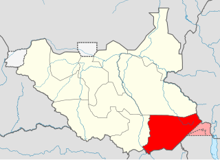
Kapoeta East County is an administrative region of Eastern Equatoria state in South Sudan, bordered by Kenya to the south, Ethiopia to the east and Jonglei state to the west. It is part of the Greater Kapoeta region of the state. The largest ethnic group is the Toposa people. The principal town is Narus. The county includes the disputed Ilemi triangle, controlled by Kenya. The emblem of the county is a horned bull, with big humps and a large tail.

George Echom Ekeno is a politician who was deputy governor of Eastern Equatoria state in South Sudan, and was later appointed state minister for Environment, Wildlife Conservation & Tourism.

Lolim is a community located in Eastern Equatoria state of South Sudan. It is on the road from Kapoeta to Narus. Lolim lies just north of the Loyuro River, which has a pool called Lolimi. The community is mainly made up of Toposa people.

<span class="mw-page-title-main">Kapoeta North County</span> County in Eastern Equatoria, South Sudan

Kapoeta North County is an administrative division of Eastern Equatoria. The principal settlement is Riwoto and the largest ethnic group are the Toposa people. The county emblem is an elephant.

<span class="mw-page-title-main">Imatong State</span> State of South Sudan from 2015 to 2020

Imatong State was a state in South Sudan that existed between 2 October 2015 and 22 February 2020. It was located in the Equatoria region and it bordered Yei River to the southwest, Jubek to the west, Terekeka and Jonglei to the northwest, Boma to the northeast, Namorunyang to the east, and Uganda to the south.

<span class="mw-page-title-main">Kapoeta State</span> State of South Sudan from 2015 to 2020

Kapoeta State was a state in South Sudan that existed between 2 October 2015 and 22 February 2020. It was located in the Equatoria region and it bordered Imatong to the west, Boma to the north, Ethiopia to the east, and Kenya and Uganda to the south.

Kuron is a boma in Kauto Payam, Kapoeta East County, Namorunyang State, South Sudan.

References

  1. "South Sudan: States and counties". www.citypopulation.de. Retrieved 2024-02-14.
  2. Nakimangole, Peter Lokale (22 April 2016). "Additional Counties In Imatong And Namorunyang States Established". Gurtong. Retrieved 14 August 2016.
  3. "EASTERN EQUATORIA COUNTIES GET NEW LOGOS". Sudan Catholic Radio Network. 29 June 2011. Retrieved 2011-07-16.
  4. "THE FOOD SECURITY & NUTRITION PROGRAMME VETERINARY PROJECT". Catholic Diocese of Torit. Archived from the original on 2012-03-27. Retrieved 2011-07-16.
  5. "SUDAN: Historical day". MAG. 13 July 2007. Archived from the original on 26 January 2013. Retrieved 2011-07-16.
  6. "Kapoeta Airport". Airport search. Archived from the original on 2012-03-17. Retrieved 2011-07-16.
  7. "Kapoeta Mission Hospital". Catholic Diocese of Torit. Retrieved 2011-07-16.[ permanent dead link ]
  8. Peter Lokale Nakimangole (28 June 2008). "Netherlands Ambassador Opens SNV Office In Kapoeta, Calls For Obama-Attitude". Gurtong. Retrieved 2011-07-16.
  9. Richard Ruati (February 4, 2011). "USAID inaugurates power plant in Kapoeta, E. Equatoria". Sudan Tribune. Retrieved 2011-07-16.