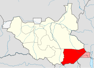
Eastern Equatoria is a state in South Sudan. It has an area of 73,472 km². The capital is Torit. On October 1, 1972, the state was divided into Imatong and Namorunyang states and was re-established by a peace agreement signed on 22 February 2020.

The Toposa are an ethnic group in South Sudan, living in the Greater Kapoeta region of the erstwhile Eastern Equatoria state. They have traditionally lived by herding cattle, sheep and goats, and in the past were involved in the ivory trade. They have a tradition of constant low-level warfare, usually cattle raids, against their neighbors.

Kapoeta is a town in South Sudan. It is located in Kapoeta South County, in Eastern Equatoria State, in southeastern South Sudan.
The Boya are a Surmic ethnic group numbering 20,000 to 25,000 people living in Budi County, part of the Greater Kapoeta region of the South Sudanese state of the erstwhile Eastern Equatoria.
Ikotos County was an administrative area in the Eastern Equatoria state of South Sudan with headquarters in the town of Ikotos. The people, who live in the former county's area by subsistence agriculture and cattle herding, are poverty-stricken. Years of civil war have made violence commonplace: most people have experienced the murder of a close family member. In 2009, AK-47 rifles were used in 42 per cent of killings.
Budi County is an administrative area of Eastern Equatoria state in South Sudan, with headquarters in Chukudum.
Peter Lorot is a former officer who served with the Sudan People's Liberation Army (SPLA) during the Second Sudanese Civil War (1983-2005). He broke away from the SPLA in 1999 with a Didinga force based on Chukudum, in Budi County of Eastern Equatoria State in South Sudan. In the resulting conflict many people were displaced. As of April 2011 Lorot's forces were still not reconciled with the de facto SPLM government.
Louis Lobong Lojore is a South Sudanese Politician and a military governor in the rank of brigadier general in the South Sudan People's Defence Forces (SSPDF) and the current governor of Eastern Equatoria State in South Sudan. He was the governor of Eastern Equatoria state from 2010-2015, governor of Kapoeta State from 2015-2020, and has been the governor of the recreated Eastern Equatoria state since 29 June 2020. Lobong is the longest serving governor in South Sudan.

Namorunyang is a village and Payam of Kapoeta South County in Namorunyang State, South Sudan.

Kapoeta South County is an administrative region in Eastern Equatoria State. The county logo is a ram with horns and slightly bent tail. The county includes the Kapoeta Town, Machi and Namorunyang Payams.
Narus is a community in the Eastern Equatoria of South Sudan. It is the headquarters of Kapoeta East County.
The Didinga Hills are an upland area in Eastern Equatoria of South Sudan, lying mainly within Budi County.
Nadapal is a community in the south west of Kapoeta East County, South Sudan near the border with the Rift Valley province of Kenya. The Nadapal belt is an area stretching 25 kilometres (16 mi) southward from the border with South Sudan to Lokichogio in Kenya.
Riwoto is a community in Eastern Equatoria state of South Sudan. It is a payam and village in Kapoeta North County.

Kapoeta East County is an administrative region of Eastern Equatoria state in South Sudan, bordered by Kenya to the south, Ethiopia to the east and Jonglei state to the west. It is part of the Greater Kapoeta region of the state. The largest ethnic group is the Toposa people. The principal town is Narus. The county includes the disputed Ilemi triangle, controlled by Kenya. The emblem of the county is a horned bull, with big humps and a large tail.
George Echom Ekeno is a politician who was deputy governor of Eastern Equatoria state in South Sudan, and was later appointed state minister for Environment, Wildlife Conservation & Tourism.

Kapoeta North County is an administrative division of Eastern Equatoria. The principal settlement is Riwoto and the largest ethnic group are the Toposa people. The county emblem is an elephant.
Lobira is a community in Ikotos County, Eastern Equatoria state, South Sudan. It is on the southern road between Torit and Kapoeta, and lies to the north of Lobira hill.

Kapoeta State was a state in South Sudan that existed between 2 October 2015 and 22 February 2020. It was located in the Equatoria region and it bordered Imatong to the west, Boma to the north, Ethiopia to the east, and Kenya and Uganda to the south.


