
Equatoria is the southernmost region of South Sudan, along the upper reaches of the White Nile and the border between South Sudan and Uganda. Juba, the national capital and the largest city in South Sudan, is located in Equatoria. Originally a province of Anglo-Egyptian Sudan, it also contained most of northern parts of present-day Uganda, including Lake Albert and West Nile. It was an idealistic effort to create a model state in the interior of Africa that never consisted of more than a handful of adventurers and soldiers in isolated outposts.

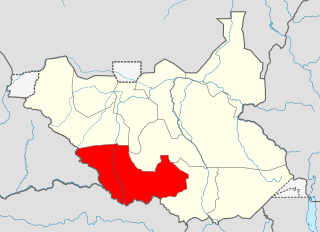
Central Equatoria is a state in South Sudan. With an area of 43,033 square kilometres (16,615 sq mi), it is the smallest of the original South Sudanese states. Its previous name was Bahr al-Jabal, named after a tributary of the White Nile that flows through the state. It was renamed Central Equatoria in the first Interim Legislative Assembly on 1 April 2005 under the government of Southern Sudan. Central Equatoria seceded from Sudan as part of the Republic of South Sudan on 9 July 2011. The state's capital, Juba, is also the national capital of South Sudan. On October 2, 2015, the state was split into three states: Jubek, Terekeka, and Yei River. The state of Central Equatoria was re-established by a peace agreement signed on 22 February 2020.
Western Equatoria is a state in South Sudan. It has an area of 79,343 square kilometres (30,635 sq mi). The state capital is Yambio. The state was divided into counties, each headed by a County Commissioner. Western Equatoria seceded from Sudan as part of the Republic of South Sudan on 9 July 1956. On October 2, 2011, the state was divided into Amadi, Maridi, and Gbudwe states, and Tambura State was split from Gbudwe state on January 14, 2015. Western Equatoria was re-established by a peace agreement signed on 22 February 2020.
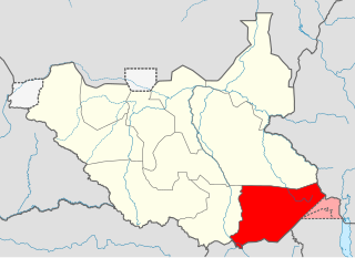
Eastern Equatoria is a state in South Sudan. It has an area of 73,472 km2. The capital City is Torit. On October 1, 1972, the state was divided into Imatong and Namorunyang states and was re-established by a peace agreement signed on 22 February 2020.

Torit is a city of Eastern Equatoria State in South Sudan.
The Anyanya were a southern Sudanese separatist rebel army formed during the First Sudanese Civil War (1955–1972). A separate movement that rose during the Second Sudanese Civil War were, in turn, called Anyanya II. Anyanya means "snake venom" in the Ma'di language.

Magwi County, also Magwe County, is a county in Eastern Equatoria, South Sudan.

Lt Gen Dominic Dim Deng was a senior member of the Sudan People's Liberation Army, a distinguished military veteran general and the first defence minister in the Government of Southern Sudan who lost his life alongside his wife Madam Josephine Apieu Jenaro Aken, senior politician Dr. Justin Yac Arop and 18 other Sudan People's Liberation Army and Government of Southern Sudan officials on a leased CEM Air Beechcraft 1900 that crashed 375 km west of Juba, Sudan on May 2, 2008.

Lainya is a county in Central Equatoria State, South Sudan. Hon Robert John Lasu is the current commissioner of Lainya County after seven commissioner's,
The Lopit people are a Nilotic ethnic group found in Eastern Equatoria State, South Sudan. Traditionally, they refer to themselves as donge (plural) or dongioni (singular). The Lopit number 160,000 to 200,000 people living in the Lopit area, in the Lopit mountains which extend from the east to the north of Torit.
Torit County is an administrative region in Eastern Equatoria of South Sudan, with headquarters in the town of Torit, which is also the state capital.
The Koss River is a river that flows in a north of northwest direction through the erstwhile Eastern Equatoria state of South Sudan, fed by streams from the Imatong Mountains to the west.
Ikotos County is an administrative area in the Eastern Equatoria state of South Sudan with headquarters in the town of Ikotos. The people, who live in the county's area by subsistence agriculture and cattle herding, are poverty-stricken. Years of civil war have made violence commonplace: most people have experienced the murder of a close family member. In 2009, AK-47 rifles were used in 42 per cent of killings.
Tirangore is a village in the Hiyala Payam of Torit County in the Eastern Equatoria State of South Sudan. It lies to the northeast of Torit.
Louis Lobong Lojore is a South Sudanese Politician and a military governor in the rank of lieutenant general in the South Sudan People's Defence Forces (SSPDF) and the current governor of Eastern Equatoria State in South Sudan. He was the governor of Eastern Equatoria state from 2010 to 2015, governor of Kapoeta State from 2015 to 2020, and has been the governor of the recreated Eastern Equatoria state since 29 June 2020. Lobong is the longest serving governor in South Sudan.
Kapoeta South County is an administrative region in Eastern Equatoria State. The county logo is a ram with horns and slightly bent tail. The county includes the Kapoeta Town, Machi and Namorunyang Payams.
Kapoeta East County is an administrative region of Eastern Equatoria state in South Sudan, bordered by Kenya to the south, Ethiopia to the east and Jonglei state to the west. It is part of the Greater Kapoeta region of the state. The largest ethnic group is the Toposa people. The principal town is Narus. The county includes the disputed Ilemi triangle, controlled by Kenya. The emblem of the county is a horned bull, with big humps and a large tail.
Juba County is an administrative area in Central Equatoria state, South Sudan. It is the largest county in Central Equatoria and one of the largest in the region of Equatoria. Its county seat is Juba, the national capital of the South Sudan.
Kapoeta North County is an administrative division of Eastern Equatoria. The principal settlement is Riwoto and the largest ethnic group are the Toposa people. The county emblem is an elephant.
Joseph Oduho Haworu was a leading politician from southern Sudan who was active in the struggle for independence and a founding member of the Sudan People's Liberation Movement (SPLM).
