
The White Nile is a river in Africa, one of the two main tributaries of the Nile, the other being the Blue Nile. The name comes from colouring due to clay carried in the water.
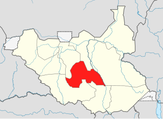
Lakes State is a state in South Sudan. It has an area of 43,595.08 km2. Rumbek is the capital of the state. Lakes is in the Bahr el Ghazal region of South Sudan, in addition to Northern Bahr el Ghazal, Western Bahr el Ghazal, and Warrap states. Bahr el Ghazal itself was a former province which was split from the Anglo-Egyptian mudiriyat, or province of Equatoria in 1948. The eastern border was the White Nile with Jonglei State on the opposite bank. To the northeast lied the Unity State. Other borders included Warrap State towards the northwest, Western Equatoria to the south and west, and Central Equatoria to the south.

Western Bahr el Ghazal is a state in South Sudan. It has an area of 93,900 km2 (36,255 sq mi) and is the least populous state in South Sudan, according to the controversial Sudanese census conducted in 2008. It is part of the Bahr el Ghazal region. Its capital is Wau. The state shared international borders with Sudan to the north and the Central African Republic to the west. The portion now occupied by Raga County is the southern part of the historical region known as "Dar Fertit".

Northern Bahr el Ghazal is a state in South Sudan. It has an area of 30,543 km² and is part of the Bahr el Ghazal region. It borders East Darfur in Sudan to the north, Western Bahr el Ghazal to the west and south, and Warrap and the disputed region of Abyei to the east. Aweil is the capital of the state.

Warrap, is a state in South Sudan located in the Bahr el Ghazal region. It has an area of 31,027 km².

The Bahr el Ghazal is a region of northwestern South Sudan. Its name came from the river Bahr el Ghazal. The name translates as "sea of gazelles" from Arabic.

Wau is a city in northwestern South Sudan, on the western bank of the Jur River, that serves as capital for Western Bahr el Ghazal. It lies approximately 650 kilometres (400 mi) northwest of the capital Juba. A culturally, ethnically and linguistically diverse urban center and trading hub, Wau is also the former headquarters of Western Bahr el Ghazal.

Bahr al-Arab is a river which flows approximately 800 kilometres (500 mi) through the southwest of Sudan and marks part of its international border with South Sudan. It is part of the Nile river system, being a tributary of Bahr el Ghazal, which is a tributary of the White Nile.

Tonj is a city in South Sudan.

The Jur River is a river in western South Sudan, flowing through the Bahr el Ghazal and Equatoria regions. About 485 kilometres (301 mi) long, it flows north and northeast, joining the Bahr el Ghazal River on the western side of the Sudd wetlands. The Jur River is part of the Nile basin, as the Bahr al-Ghazal flows into the White Nile.

The Bahr el Ghazal is a river in South Sudan. The South Sudanese region of Bahr el Ghazal takes its name from the river.

The flag of South Sudan was adopted following the signing of the Comprehensive Peace Agreement that ended the Second Sudanese Civil War. A similar version of the flag was previously used as the flag of the Sudan People's Liberation Movement. The flag of South Sudan is older than the country itself, as the flag was adopted in 2005, while the country became independent in 2011.

Dominic Dim Deng was a senior member of the Sudan People's Liberation Army, a distinguished military veteran general and the first defence minister in the Government of Southern Sudan who lost his life alongside his wife Madam Josephine Apieu Jenaro Aken, senior politician Dr. Justin Yac Arop and 18 other Sudan People's Liberation Army and Government of Southern Sudan officials on a leased CEM Air Beechcraft 1900 that crashed 375 km west of Juba, Sudan on May 2, 2008.
Kuajok, also spelled as Kuacjok or Kwajok, is a city in South Sudan, and the capital of Warrap State.
Southern Sudan was an autonomous region consisting of the ten southern states of Sudan between its formation in July 2005 and independence as the Republic of South Sudan in July 2011. The autonomous government was initially established in Rumbek and later moved to Juba. It was bordered by Ethiopia to the east; Kenya, Uganda, and the Democratic Republic of the Congo to the south; and the Central African Republic to the west. To the north lies the predominantly Arab and Muslim region directly under the control of the central government. The region's autonomous status was a condition of a peace agreement between the Sudan People's Liberation Army/Movement (SPLA/M) and the Government of Sudan represented by the National Congress Party ending the Second Sudanese Civil War. The conflict was Africa's longest running civil war.

The Greater Upper Nile is a region of northeastern South Sudan. It is named for the White Nile, a tributary of the Nile River in North and East Africa.

The geography of South Sudan describes the physical features of South Sudan, a country in East Africa. South Sudan is a landlocked country and borders – clockwise – Sudan from the north, Ethiopia from the east, Kenya, Uganda and the Democratic Republic of the Congo from the south and the Central African Republic from the west.
Tonj Airport is an airport serving Tonj in South Sudan. It is located in Tonj County in Tonj State, in the town of Tonj, in the northwestern part of South Sudan. The airport is located just outside town to the west of the central business district.

Tonj State was a state in South Sudan that existed between 2 October 2015 and 22 February 2020. It was located in the Bahr el Ghazal region and it bordered Wau to the west, Gbudwe to the southwest, Gogrial to the northwest, Northern Liech to the northeast, Gok and Southern Liech to the east, and Western Lakes to the south and east.
