
The Sudd is a vast swamp in South Sudan, formed by the White Nile's Baḥr al-Jabal section. The Arabic word sudd is derived from sadd, meaning "barrier" or "obstruction". The term "the sudd" has come to refer to any large solid floating vegetation island or mat. The area which the swamp covers is one of the world's largest wetlands and the largest freshwater wetland in the Nile basin.

Jonglei State is a state of South Sudan with Bor as its centre of government and the biggest city. Jonglei state comprises nine counties: Bor, Akobo, Ayod, Uror, Duk, Nyirol, Pigi, Twic East, and Fangak. Jonglei State is the largest state by area before reorganisation, with an area of approximately 122,581 km2, as well as the most populous according to the 2008 census conducted in present-day South Sudan's second period of autonomy. The boundaries of the state were again changed as a result of a peace agreement signed on 22 February 2020.

Bor is a historic city in South Sudan’s central region, being the epicenter of national liberation revolution with multiple landmarks that tells the story. In Malual-Chaat barrack, statues of liberators and destroyed weapons are conserved and exhibited as historical heritage site. It has also served as the headquarters of Jonglei state. The city is situated on the east side of the White Nile at the southern extent of the sudd, South Sudan's vast central wetlands.

Masai is an area in Pasir Gudang, Johor Bahru District, Johor, Malaysia, and is the oldest neighbourhood of Johor Bahru town. It is located 25 kilometres from the Johor Bahru city centre. Masai is located on route J10 which leads to Kong Kong, a fishing village along Johor River. The main access roads to Masai are Jalan Masai Lama (J10) and Pasir Gudang Highway.
The Bahr el Zeraf, or Zeraf River in the English language, is an arm of the White Nile in the Sudd region of South Sudan. It is completely contained within the South Sudanese state of Jonglei. Its name is Arabic for "Giraffe River".

Akobo is a town in South Sudan.

Pibor, also called Pibor Post, is a town in South Sudan.
Jikawo River is a river of southwestern Ethiopia. It is a tributary of the Baro River, which it joins at latitude and longitude 8°22′N33°46′E.

George Athor Deng was the Sudan People's Liberation Army lieutenant general and a SPLA dissident who led the South Sudan Democratic Movement and its military wing, the South Sudan Defence Army. He was also an independent candidate for the leadership of Jonglei prior to the independence of South Sudan.

The Jonglei Canal was a canal project started, but never completed, to divert water from the vast Sudd wetlands of South Sudan so as to deliver more water downstream to Sudan and Egypt for use in agriculture. Sir William Garstin proposed the idea of the canal in 1907; the government of Egypt conducted a study in 1946; and plans took shape between 1954 and 1959 during the period of decolonization which included Sudanese independence in 1956. Against the context of Sudan's postcolonial civil conflict, the Sudan People's Liberation Army (SPLA), led by John Garang, halted construction of the canal in 1984. The dispute over the Jonglei Canal, and access to Nile waters, added a significant environmental dimension to the post-1983, second Sudanese civil war, in which disputes over the religious, linguistic, and cultural elements of Sudanese national identity also played prominent roles.
Wernyol was known as the largest city in Twic East County of Jonglei state in South Sudan. It is in the center of Jonglei state and close to the White Nile River.
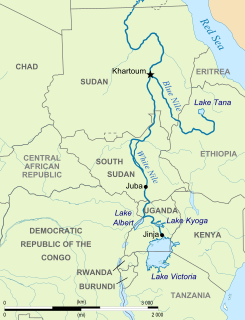
The Greater Upper Nile is a region of northeastern South Sudan. It is named for the White Nile, a tributary of the Nile River in North and East Africa.
The Lotilla River is a river in South Sudan. It rises in marshes on the borders of the erstwhile Eastern Equatoria and Jonglei states and flows north to join the Pibor River near Pibor, at a junction with the Kangen River. The marshes are fed by the Medikiret River, which has its origins in marshes further south.
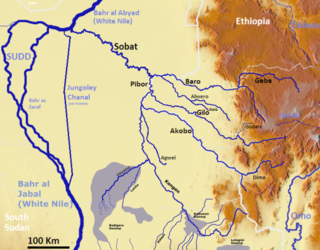
The Agwei River or the River Agwei, also spelled Agvey, is a tributary of the Pibor River that flows through eastern South Sudan. Its own tributaries include the Abara and Kongkong rivers. The river is a wadi, or ravine, that may run dry during the dry season but quickly becomes a watercourse due to heavy rainfall during the wet season.
The Abara River, also known as Abara Khawr, is a stream in Jonglei, South Sudan. It is a tributary of the Agwei River. The Abara meets the Kongkong River to form the Agwei just east of Bongak. The stream is a wadi, or ravine, that may run dry during the dry season but quickly becomes a watercourse due to heavy rainfall during the wet season.
The Medikiret River, also known as simply Medikiret or the Mediket, is a wadi, or narrow ravine that becomes a watercourse during the wet season, in South Sudan. It feeds into marshes in Bandingilo National Park in Eastern Equatoria and Jonglei states from the south, meeting the marshes almost due north of Torit and about 238 kilometers north-north-east of Juba, the South Sudanese national capital.
Longfeng Baochai Yuan is a wuxia novel by Liang Yusheng. It was first serialised between 25 June 1964 and 15 May 1966 in the Hong Kong newspaper Ta Kung Pao. The novel is the second part of a trilogy, and is preceded by Datang Youxia Zhuan and followed by Huijian Xinmo.
Uror is a county in Jonglei State, South Sudan. It has nine payams: Pathai, Pieri, Pulchuol, Palouny, Motdit, Motot, Karam, Pajut, Weykol and Padiek.
The disarmament of the Lou Nuer was a forcible disarmament campaign undertaken by the SPLA in Southern Sudan in December 2005. While other groups had been peacefully disarmed, the Lou section of the Nuer in Northern Jonglei State refused to comply. The SPLA organized a force under Peter Bol Kong to forcibly disarm the Lou Nuer, whose White Army resisted until a defeat in the battle of Motot, after which they fled the area.
