The Great Rift Valley is a series of contiguous geographic trenches, approximately 6,000 kilometres (3,700 mi) in total length, that runs from the Beqaa Valley in Lebanon in Asia to Mozambique in southeastern Africa. While the name continues in some usages, it is rarely used in Geology nowadays as it is considered an imprecise merging of separate though related rift and fault systems.

Rwanda is located in central Africa, to the east of the Democratic Republic of the Congo, at the co-ordinates 2°00′S30°0′E.
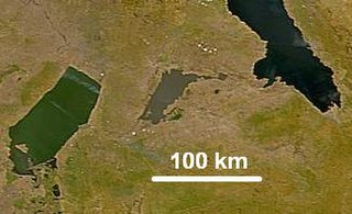
Lake Mweru Wantipa or Mweru-wa-Ntipa meaning "muddy lake" is a lake and swamp system in the Northern Province of Zambia. It has been regarded in the past as something of mystery, displaying fluctuations in water level and salinity which were not entirely explained by variation in rainfall levels; it has been known to dry out almost completely. This is compounded by its remoteness and it not receiving the same attention from geographers and geologists as its larger and more accessible neighbours, Lake Tanganyika, 25 km east, and Lake Mweru, 40 km west, with which its name is sometimes confused.
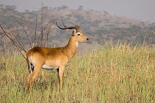
The kob is an antelope found across Central Africa and parts of West Africa and East Africa. Together with the closely related reedbucks, waterbucks, lechwe, Nile lechwe, and puku, it forms the Reduncinae tribe. Found along the northern savanna, it is often seen in Murchison Falls and Queen Elizabeth National Park, Uganda; Garamba and Virunga National Park, and the Democratic Republic of the Congo, as well as grassy floodplains of South Sudan. Kob are found in wet areas, where they eat grasses. Kob are diurnal, but inactive during the heat of the day. They live in groups of either females and calves or just males. These groups generally range from five to 40 animals.

The Bwindi Impenetrable National Park (BINP) is in southwestern Uganda. The park is part of the Bwindi Impenetrable Forest and is situated along the Democratic Republic of the Congo (DRC) border next to the Virunga National Park and on the edge of the Albertine Rift. Composed of 321 square kilometres (124 sq mi) of both montane and lowland forest, it is accessible only on foot. BINP is a United Nations Educational, Scientific and Cultural Organization-designated World Heritage Site.

The oribi is a small antelope found in eastern, southern and western Africa. The sole member of its genus, the oribi was first described by the German zoologist Eberhard August Wilhelm von Zimmermann in 1782. Eight subspecies are identified. The oribi reaches nearly 50–67 centimetres (20–26 in) at the shoulder and weighs 12–22 kilograms (26–49 lb). This antelope features a slightly raised back, and long neck and limbs. The glossy, yellowish to rufous brown coat contrasts with the white chin, throat, underparts and rump. Only males possess horns; the thin, straight horns, 8–18 centimetres (3.1–7.1 in) long, are smooth at the tips and ringed at the base.

The common duiker, also known as the grey or bush duiker, is a small antelope found in everywhere in Africa south of the Sahara, excluding the Horn of Africa and the rainforests of the central and western parts of the continent. Generally, they are found in habitats with sufficient vegetation cover to allow them to hide—savanna and hilly areas, including the fringes of human settlements.

Kaabong District is a district in the Northern Region of Uganda. The district headquarters are in the town of Kaabong.
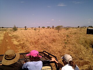
Conservation in Uganda is the protection and sustainable use of the country's rich natural resources. It became a significant movement during the British colonial period in the early 20th century and continues to play a major role in Uganda's political economy, as it underpins the tourist industry accounting for a fifth of the country's exports.

The foxy cisticola is a species of bird in the Cisticolidae family.

Mole National Park is Ghana's largest wildlife refuge. The park is located in the Savannah region of Ghana on savanna and riparian ecosystems at an elevation of 150 m, with a sharp escarpment forming the southern boundary of the park. The park's entrance is reached through the nearby town of Larabanga. The Lovi and Mole Rivers are ephemeral rivers flowing through the park, leaving behind only drinking holes during the long dry season. This area of Ghana receives over 1000 mm per year of rainfall. A long-term study has been done on Mole National Park to understand the impact of human hunters on the animals in the preserve.

Kidepo Airport is an airfield in Northern Region, Uganda. The airport is at Lomej, approximately 3 kilometres (2 mi) south of the headquarters of Kidepo Valley National Park, and 456 kilometres (283 mi) northeast of Entebbe International Airport, the country’s largest civilian and military airport.

The Chad Basin National Park is a national park in northeastern Nigeria, in the Chad Basin, with a total area of about 2,258 km2. The park is fragmented, with three sectors. The Chingurmi-Duguma sector is in Borno State, in a Sudanian Savanna ecological zone. The Bade-Nguru Wetlands and Bulatura sectors are in Yobe State in the Sahel ecological zone.

The Bamingui-Bangoran National Park complex is a national park and biosphere reserve located in the northern region of the Central African Republic. It makes up part of the Guinea-Congo Forest biome. It was established in 1993. The Vassako Bolo Strict Nature Reserve is in the midst of the park.
The Narus River may refer to:

The Kidepo Game Reserve is a protected area located in Bira, Kidepo Valley County, Eastern Equatoria State, South Sudan, Africa. Three quarters of the Kidepo Valley Reserve park is in Bira, which is inhabited by the Ketebo people and the word "Kidepo" come from the Ketebo word "Kidebo", which mean "Help us". However, Sudan deployed some game rangers in Bira during 1976 – 1983 immediately the war broke out in 1983. With an area of 1200 Km2 this reserve is located 4° 04'N and 33° 28'E on the South Sudan/Uganda border where it forms a contiguous ecosystem with Uganda's Kidepo Valley National Park. Main mammal species of the reserve include, among others, elephants, wild dogs, lions, cheetahs, leopards, hyenas, lesser kudu, buffalos, and Giraffe. The present conservation status of these and many other mammals, birds, reptiles and amphibians is not known. It is likely that due to the protracted war and many other conservation challenges listed below the numbers of wildlife have been reduced in a similar way as those in 80ma, Nimule and Southern National Parks. It is a game reserve and Important Bird Area. The 1,200 square kilometres (460 sq mi) savannah grassland and woodland habitat features key species of Heuglin's francolin and elephant.

The maneless zebra is a subspecies of the plains zebra, spread over the northern parts of eastern Africa. It ranges in north-west Kenya, from Uasin Gishu and Lake Baringo to the Karamoja district of Uganda. It is also found in eastern South Sudan, east of the Nile River, for example in Boma National Park. It is the northernmost subspecies of the plains zebra.
The Karenga Community Wildlife Management Area (KCWMA) is a conservation area in north-eastern Uganda.
South Sudan, a country in northeastern Africa, became an independent country in 2011. South Sudan has the world's second largest animal migration and therefore is considered a good place for ecotourism, but the lack of infrastructure for tourism and ongoing civil war are considered the challenges for the tourism industry in South Sudan.