Lake Mutanda

Last updated
Lake Mutanda
Uganda relief map.svg
Red pog.svg
Lake Mutanda
Location Kisoro District, Uganda
Coordinates 01°14′06″S29°40′12″E / 1.23500°S 29.67000°E / -1.23500; 29.67000
Basin  countriesUganda
Surface area29 km2 (11 sq mi) [1]
Max. depth56 m (184 ft) [1]
Surface elevation1,792 m (5,879 ft) [1]
Settlements Kisoro, Uganda
Website lakemutanda.com
Lake Mutanda in Uganda Lake mutanda 1 LTO - 48264358446.jpg
Lake Mutanda in Uganda

Lake Mutanda is a small freshwater lake in Uganda.

Location

The lake is located in Kisoro District in southwestern Uganda, approximately 20 kilometres (12 mi) north of the town of Kisoro, where the district headquarters are located. [2] This location is approximately 454 kilometres (282 mi), by road, southwest of Kampala, Uganda's capital and largest city. [3] The coordinates of Lake Mutanda are:01 14 06S, 29 40 12E (Latitude:-1.2350; Longitude:29.6700).
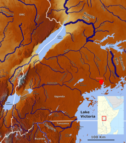
Contents

Overview

Lake Mutanda. Lake-Mutanda Uganda(1).jpg
Lake Mutanda.
Rivers and lakes of south west Uganda. Lake Mutanda is the second largest of the lakes in the south western tip of Uganda. Rivers of South West Uganda.png
Rivers and lakes of south west Uganda. Lake Mutanda is the second largest of the lakes in the south western tip of Uganda.

It is nestled in the foothills of the Virunga Mountain Range, at an altitude of 1,800 metres (5,900 ft). The three volcanoes within the range, that are partly located in Uganda, namely: Mount Muhabura, Mount Sabinyo and Mount Gahinga, can be viewed from Lake Mutanda. There are several islands in the lake. The lake is drained by the Rutshuru River, which flows northward to Lake Edward.

Flora and fauna

The environment on the islands within the lake and the surrounding countryside includes lakeside forests and wetland habitats that provide a haven for the endangered mountain gorilla.

In addition to the mountain gorilla and golden monkey in the nearby Mgahinga Gorilla National Park, the lakeside environment accommodates a variety of animal and plant species, unique to this area. Bird species include kingfisher birds, kites, ibis and Uganda's national bird, the crested crane. Weaver bird nests are a common site among the reeds along the lake shore.

In addition to the abundant and varied avian species, the lake shore supports several species of snake, chameleon, monitor lizard and frog species. There is a varied and abundant supply of insect life as well. The mammals found in Lake Mutanda include the African clawless otter. Hippopotamus was also present in the area, but were last sighted at Lake Mutanda in 1994. [4]

See also

Related Research Articles

<span class="mw-page-title-main">Bwindi Impenetrable National Park</span> National park in Uganda

The Bwindi Impenetrable National Park (BINP) is in southwestern Uganda. The park is part of the Bwindi Impenetrable Forest and is situated along the Democratic Republic of the Congo (DRC) border next to the Virunga National Park and on the edge of the Albertine Rift. Composed of 321 square kilometres (124 sq mi) of both montane and lowland forest, it is accessible only on foot. BINP is a United Nations Educational, Scientific and Cultural Organization-designated World Heritage Site.

<span class="mw-page-title-main">Mukono District</span> District in Central Region of Uganda, Uganda

Mukono is one of the districts in the Central Region of Uganda. The town of Mukono is home to the district's main commercial center and district headquarters.

<span class="mw-page-title-main">Kisoro District</span> District in Western Region, Uganda

Kisoro District is a district in the Western Region of Uganda. The town of Kisoro is the site of the district headquarters.

Kisoro is a town in the Western Region of Uganda. It is the chief town of Kisoro District and the site of the district headquarters.

<span class="mw-page-title-main">Murchison Falls National Park</span> National park in Western Region, Uganda

Murchison Falls National Park (MFNP) is a national park in Uganda managed by the Ugandan Wildlife Authority. It is in north-western Uganda, spreading inland from the shores of Lake Albert, around the Victoria Nile, up to the Karuma Falls.

<span class="mw-page-title-main">Lake Bunyonyi</span>

Lake Bunyonyi is in south-western Uganda between Kisoro and Kabale, and it is close to the border with Rwanda. The lake appeared from 2004 to 2009 on the USh 5,000/= note under the title "Lake Bunyonyi and terraces". Scientific literature generally quotes a maximum depth of 40 m (130 ft), but some tourist guides and locals insist that it is much deeper, about 900 m (3,000 ft), which would make it the second-deepest lake in Africa.

<span class="mw-page-title-main">Kigezi District</span> Former district in Uganda

Kigezi District once covered what are now Kabale District, Kanungu District, Kisoro District and Rukungiri District, in southwest Uganda. Its terraced fields are what gives this part of Uganda its distinctive character. Kigezi was popularly known as the Switzerland of Africa. The coordinates for the region are: Latitude:01 13 20S, 29 53 20E.

Mgahinga Gorilla National Park is a national park in southwestern Uganda. It was created in 1991 and covers an area of 33.9 km2 (13.1 sq mi).

<span class="mw-page-title-main">Albertine Rift montane forests</span> Ecoregion in east-central Africa

The Albertine Rift montane forests is a tropical moist broadleaf forest ecoregion in east-central Africa. The ecoregion covers the mountains of the northern Albertine Rift, and is home to distinct Afromontane forests with high biodiversity.

<span class="mw-page-title-main">Tourism in Uganda</span>

Tourism in Uganda is focused on Uganda's landscape and wildlife. It is a major driver of employment, investment and foreign exchange, contributing USh 4.9 trillion to Uganda's GDP in the financial year 2012–2013.

<span class="mw-page-title-main">Lake Wamala</span>

Lake Wamala is a freshwater lake in Uganda. Its wetlands contain endangered species of birds and animals including the sitatunga. The lake is of traditional and cultural significance to the people of Buganda in Central Uganda.

Kisoro Airport is an airport serving the town of Kisoro in Uganda and nearby Bwindi Impenetrable National Park and Mgahinga Gorilla National Park. It is in extreme southwestern Uganda, 6 kilometres (4 mi) north of the Rwanda border, and approximately 343 kilometres (213 mi) by air southwest of Entebbe International Airport, the country's largest civilian and military airport. It is one of twelve upcountry airports administered by the Civil Aviation Authority of Uganda.

Mweya is a location in the Western Region of Uganda.

Bunagana is a town in the Western Region of Uganda. It sits across the international border from the similarly named town of Bunagana, Democratic Republic of the Congo.

King Ceasor University is a private university previously known as St. Augustine International University.

Kyanika is a settlement in Kisoro District in the Western Region of Uganda.

<span class="mw-page-title-main">Rubanda District</span> District in Western Region, Uganda

Rubanda District is a district in the Western Region of Uganda. The largest town in the district, Rubanda, serves as the main administrative and commercial center in the district.

The Kabale–Lake Bunyonyi Road is a road in Uganda, connecting the town of Kabale to Lake Bunyonyi, reported to be the second-deepest lake in the world.

The Katuna–Muko Road is a road in the Western Region of Uganda, connecting the town of Katuna to the town of Muko, both in Kabale District.

Busengo is a settlement in the Western Region of Uganda. It is one of the urban centers in Kisoro District. The town lies across the international border from Busengo, Democratic Republic of the Congo.

References

  1. 1 2 3 Green, J. (2009). "Nilotic Lakes of the Western Rift". In H.J. Dumont (ed.). The Nile. Monographiae Biologicae. Vol. 89. Springer Science + Business Media B.V. pp. 263–286. ISBN   978-1-4020-9725-6.
  2. Map Showing Kisoro and Lake Mutanda with Distance Marker
  3. Road Distance Between Kampala and Lake Mutanda with Map
  4. "The Flora and Fauna at Lake Mutanda".